| Home | City Bus | Maps | Villages | Cities | Rail | Tourist Places | School | College | Pin Codes | Corona Cases Count |
| Distance Calculator Bus Services IFSC Codes Trace Mobile Number Weather Search Place Trace IP Available Cash ATM/Banks Locate Polling Booth Report an Error contact People |
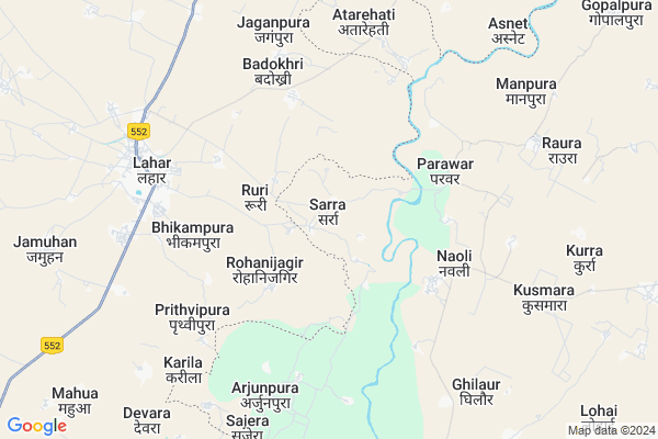
Sarra
Sarra Map
EDIT Map
Add Your House
 ..
..
Current Corona Virus Infected Patients Count in Jalaun District
| City Name | District Name | Total Covid cases |
|---|---|---|
| Jalaun District | Jalaun | 1 |
Locality Name :
Sarra
( सर्रा )
Block Name : Madhogarh
District : Jalaun
State : Uttar Pradesh
Division : Jhansi
Language : Hindi and Urdu
Current Time 05:56 PM
Date: Monday , Apr 28,2025 (IST)
Time zone: IST (UTC+5:30)
Elevation / Altitude: 158 meters. Above Seal level
Telephone Code / Std Code: 05168
Assembly constituency : Madhogarh assembly constituency
Assembly MLA : Mool Chandra Singh
Lok Sabha constituency : Jalaun parliamentary constituency
Parliament MP : BHANU PRATAP SINGH VERMA
Serpanch Name :
Pin Code : 285121
Post Office Name : Bangra
Alternate Village Name : Sarr
Commodities Prices : Lahar Market / Mandi
Sarra Live Weather
Temperature: 41.7 °C
clear sky
Humidity: 7%
Wind : 3.13 mt/sec towards N
StationName : "LahÄ\u0081r"
observed on 2 Hours Back
Temperature: 41.7 °C
clear sky
Humidity: 7%
Wind : 3.13 mt/sec towards N
StationName : "LahÄ\u0081r"
observed on 2 Hours Back
Sarra Weather Forecast for Next 5 days
29-04-2025
30.9°C to 41.3°C
clear sky
30.9°C to 41.3°C
clear sky
30-04-2025
27.7°C to 42.2°C
clear sky
27.7°C to 42.2°C
clear sky
01-05-2025
28.9°C to 42.6°C
clear sky
28.9°C to 42.6°C
clear sky
02-05-2025
30.9°C to 43.5°C
scattered clouds, few clouds, clear sky, broken clouds
30.9°C to 43.5°C
scattered clouds, few clouds, clear sky, broken clouds
03-05-2025
29.5°C to 42.1°C
scattered clouds, clear sky, broken clouds, overcast clouds, light rain
29.5°C to 42.1°C
scattered clouds, clear sky, broken clouds, overcast clouds, light rain
National Highways Reachable To Sarra
Nationa High Way :NH519
Nationa High Way :NH519
Rivers Near Sarra
Yamuna :যমুনা :યમુના :यमुना :ಯಮುನಾ :यमुना :யமுனை :Ямуна :https://1drv.ms/b/s!Ar-WXIFaX7UdgQuO6WpVrTr6YYsQ
Sindh
Yamuna :যমুনা :યમુના :यमुना :ಯಮುನಾ :यमुना :யமுனை :Ямуна :https://1drv.ms/b/s!Ar-WXIFaX7UdgQuO6WpVrTr6YYsQ
Sindh
About Sarra
Correct below Info and add more info about SarraSarra is a Village in Madhogarh Block in Jalaun District of Uttar Pradesh State, India. It belongs to Jhansi Division . It is located 39 KM towards west from District head quarters Orai. 26 KM from Madhogarh. 242 KM from State capital Lucknow
Sarra Pin code is 285121 and postal head office is Bangra .
Anghaura ( 1 KM ) , Parawar ( 4 KM ) , Naoli ( 4 KM ) , Bargawan Madhaugarh ( 5 KM ) , Atrauli ( 6 KM ) are the nearby Villages to Sarra. Sarra is surrounded by Nadigaon Block towards East , Raon Block towards North , Madhogarh Block towards East , Konch Block towards South .
Lahar , Bhajanpura , Samthar , Orai are the near by Cities to Sarra.
Sarra 2011 Census Details
Sarra Local Language is Hindi. Sarra Village Total population is 1895 and number of houses are 309. Female Population is 45.6%. Village literacy rate is 50.4% and the Female Literacy rate is 17.2%.
Population
| Census Parameter | Census Data |
| Total Population | 1895 |
| Total No of Houses | 309 |
| Female Population % | 45.6 % ( 865) |
| Total Literacy rate % | 50.4 % ( 956) |
| Female Literacy rate | 17.2 % ( 325) |
| Scheduled Tribes Population % | 0.0 % ( 0) |
| Scheduled Caste Population % | 29.4 % ( 558) |
| Working Population % | 26.9 % |
| Child(0 -6) Population by 2011 | 278 |
| Girl Child(0 -6) Population % by 2011 | 46.0 % ( 128) |
Sarra Census More Deatils.
Politics in Sarra
BJP , SP , BSP , INC are the major political parties in this area.Polling Stations /Booths near Sarra
1)Anda2)Saravan
3)Paravar
4)Kanharpura
5)Malviya Nagar Madhaugarh
HOW TO REACH Sarra
By Rail
There is no railway station near to Sarra in less than 10 km.Colleges near Sarra
Bundelkhand Inter College
Address :
Dr.bhimrav Ambedkar Inter College Ooncha
Address :
Schools in Sarra
Ups Sarr
Address : sarr , madhaugadh , jalaun , Uttar Pradesh . PIN- 285121 , Post - Bangra
Govt Health Centers near Sarra
1) CHC Udi , CHC UDI , UDI GAON , NEAR GGIC SCHOOL2) Lohai Diwara , , ,
3) Madhogarh , SUB CENTER , madhogarh , CHC MADHOGARH
Sub Villages in Sarra
Hospitals in Sarra,Madhogarh
Primary Health Centre Nadigoan
Bus Stand Nadigoan U P.; Konch; Uttar Pradesh; India
10.0 KM distance Detail
more ..
Petrol Bunks in Sarra,Madhogarh
Hindustan Petroleum
SH-70; Jalaun District; Bangra; Uttar Pradesh 285121; India
19.1 KM distance Detail
more ..
About Sarra &
History
How to reach Sarra
Tourist Places Near By Sarra
Schools in Sarra
Colleges in Sarra
Temperature & weather of Sarra
places in Sarra
Sarra photos
More Information
How to reach Sarra
Tourist Places Near By Sarra
Schools in Sarra
Colleges in Sarra
Temperature & weather of Sarra
places in Sarra
Sarra photos
More Information
Village Talk
Post News or Events about this Village
Near Cities
Lahar 6 KM near
Bhajanpura 38 KM near
Samthar 42 KM near
Orai 55 KM near
Lahar 6 KM near
Bhajanpura 38 KM near
Samthar 42 KM near
Orai 55 KM near
Near By Taluks
Lahar 12 KM near
Nadigaon 14 KM near
Raon 19 KM near
Madhogarh 25 KM near
Lahar 12 KM near
Nadigaon 14 KM near
Raon 19 KM near
Madhogarh 25 KM near
Near By Air Ports
Gwalior Airport 87 KM near
Kanpur Airport 160 KM near
Kheria Airport 167 KM near
Khajuraho Airport 198 KM near
Gwalior Airport 87 KM near
Kanpur Airport 160 KM near
Kheria Airport 167 KM near
Khajuraho Airport 198 KM near
Near By Tourist Places
Datia 86 KM near
Sonagir 90 KM near
Gwalior 91 KM near
Jhansi 103 KM near
Orchha 111 KM near
Datia 86 KM near
Sonagir 90 KM near
Gwalior 91 KM near
Jhansi 103 KM near
Orchha 111 KM near
Near By Districts
Jalaun 37 KM near
Bhind 54 KM near
Auraiya 67 KM near
Etawah 73 KM near
Jalaun 37 KM near
Bhind 54 KM near
Auraiya 67 KM near
Etawah 73 KM near
Near By RailWay Station
Ait Junction Rail Way Station 43 KM near
Moth Rail Way Station 54 KM near
Ait Junction Rail Way Station 43 KM near
Moth Rail Way Station 54 KM near