| Home | City Bus | Maps | Villages | Cities | Rail | Tourist Places | School | College | Pin Codes | Corona Cases Count |
| Distance Calculator Bus Services IFSC Codes Trace Mobile Number Weather Search Place Trace IP Available Cash ATM/Banks Locate Polling Booth Report an Error contact People |
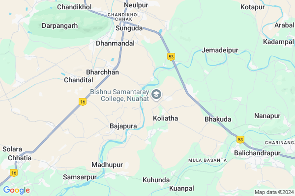
Nilamberpur Map
EDIT Map
Add Your House
 ..
..
Current Corona Virus Infected Patients Count in Jajapur District
| City Name | District Name | Total Covid cases |
|---|
Locality Name :
Nilamberpur
( ନୀଳାମ୍ବରପୂର୍ଵ )
Tehsil Name : Badchana
District : Jajapur
State : Odisha
Language : Oriya and Hindi,
Current Time 01:18 PM
Date: Sunday , Apr 27,2025 (IST)
Time zone: IST (UTC+5:30)
Elevation / Altitude: 38 meters. Above Seal level
Telephone Code / Std Code: 06728
Assembly constituency : Barchana assembly constituency
Assembly MLA : amar prasad satpathy
Lok Sabha constituency : Jajpur parliamentary constituency
Parliament MP : SARMISTHA SETHI
Serpanch Name :
Pin Code : 754024
Post Office Name : Dhanmandal
Alternate Village Name : Nilambarpur
Commodities Prices : Kendupatna Market / Mandi
National Highways Reachable To Nilamberpur
Nationa High Way :NH55
Nationa High Way :NH53
Nationa High Way :NH55
Nationa High Way :NH53
Rivers Near Nilamberpur
Devi River
Sapua
Devi River
Sapua
About Nilamberpur
Correct below Info and add more info about NilamberpurNilamberpur is a small Village/hamlet in Badchana Tehsil in Jajapur District of Odisha State, India. It is located 35 KM towards South from District head quarters Jajpur. 4 KM from Badachana. 61 KM from State capital Bhubaneswar
Nilamberpur Pin code is 754024 and postal head office is Dhanmandal .
Badachana ( 5 KM ) , Haripur ( 5 KM ) , Chandital ( 6 KM ) , Anaka ( 7 KM ) , Balichandrapur ( 9 KM ) are the nearby Villages to Nilamberpur. Nilamberpur is surrounded by Mahanga Tehsil towards South , Dahrmasala Tehsil towards North , Salepur Tehsil towards South , Rasulpur Tehsil towards North .
Jajapur , Kendrapara , Byasanagar , Cuttack are the near by Cities to Nilamberpur.
This Place is in the border of the Jajapur District and Cuttack District. Cuttack District Mahanga is South towards this place .
Nilambarpur 2011 Census Details
Nilamberpur Local Language is Oriya. Nilambarpur Village Total population is 599 and number of houses are 133. Female Population is 45.4%. Village literacy rate is 90.5% and the Female Literacy rate is 41.6%.
Population
| Census Parameter | Census Data |
| Total Population | 599 |
| Total No of Houses | 133 |
| Female Population % | 45.4 % ( 272) |
| Total Literacy rate % | 90.5 % ( 542) |
| Female Literacy rate | 41.6 % ( 249) |
| Scheduled Tribes Population % | 0.0 % ( 0) |
| Scheduled Caste Population % | 6.3 % ( 38) |
| Working Population % | 29.0 % |
| Child(0 -6) Population by 2011 | 50 |
| Girl Child(0 -6) Population % by 2011 | 42.0 % ( 21) |
Nilambarpur Census More Deatils.
Politics in Nilamberpur
NCP , BJD , INC are the major political parties in this area.Polling Stations /Booths near Nilamberpur
1)Nigamananda Bidyapitha Barada (es)2)Baunshaput Pry. School
3)Bayalismouja High School Arakhapur (es)
4)Ichhanagarapatana Pry. School
5)Bandhapali Pry. School Bandhapali
HOW TO REACH Nilamberpur
By Rail
Dhanmandal Rail Way Station , Haridaspur Rail Way Station are the very nearby railway stations to Nilamberpur.Colleges near Nilamberpur
Mahapurusha Hadidas Mahavidyalaya
Address :
Baba Banaamali Das Mahavidyalaya
Address : Sailipada,p.o-salapada,p.s- Barachana,dist-jajpur-754082
Schools in Nilamberpur
Sarangpur U.p.s
Address : nilambarpur , barchana , jajpur , Sikkim . PIN- 754296
Govt Health Centers near Nilamberpur
1) Haripur SC , 38 , Balia , Nahan Nodal UP School2) Kabatabandha SC , Upaswasthya kendra Kabatbandha , 44 , PHC N Campous
3) ORTI , , , Orti PHC (New)
Petrol Bunks in Nilamberpur,Badchana
Bharat Petroleum
Buduchana; Jajapur; NH-5; Baharagora Chennai Highway; Badchana; Badchana; Odisha 754296; India
3.7 KM distance Detail
more ..
Electronic Shops in Nilamberpur,Badchana
SR Enterprises
754296; Nua Sunguda; Sunguda-Chandikhole Rd; Odisha; 754296; Nua Sunguda; Odisha 754296; India
6.2 KM distance Detail
Police Stations near Nilamberpur,Badchana
Chandikhol Traffic Police
; Chandikhol Chhak; Khosalpur; Odisha 755044; India
6.9 KM distance Detail
About Nilamberpur &
History
How to reach Nilamberpur
Tourist Places Near By Nilamberpur
Schools in Nilamberpur
Colleges in Nilamberpur
Temperature & weather of Nilamberpur
places in Nilamberpur
Nilamberpur photos
More Information
How to reach Nilamberpur
Tourist Places Near By Nilamberpur
Schools in Nilamberpur
Colleges in Nilamberpur
Temperature & weather of Nilamberpur
places in Nilamberpur
Nilamberpur photos
More Information
Village Talk
Post News or Events about this Village
Near Cities
Jajapur 32 KM near
Kendrapara 36 KM near
Byasanagar 36 KM near
Cuttack 39 KM near
Jajapur 32 KM near
Kendrapara 36 KM near
Byasanagar 36 KM near
Cuttack 39 KM near
Near By Taluks
Badchana 4 KM near
Mahanga 12 KM near
Dahrmasala 14 KM near
Salepur 20 KM near
Badchana 4 KM near
Mahanga 12 KM near
Dahrmasala 14 KM near
Salepur 20 KM near
Near By Air Ports
Bhubaneswar Airport 62 KM near
Ranchi Airport 345 KM near
Netaji Subhas Chandra Bose Airport 363 KM near
Vishakhapatnam Airport 500 KM near
Bhubaneswar Airport 62 KM near
Ranchi Airport 345 KM near
Netaji Subhas Chandra Bose Airport 363 KM near
Vishakhapatnam Airport 500 KM near
Near By Tourist Places
Cuttack 39 KM near
Nandan Kanan National Park 50 KM near
Bhubaneswar 58 KM near
Paradeep Beach 68 KM near
Konark 94 KM near
Cuttack 39 KM near
Nandan Kanan National Park 50 KM near
Bhubaneswar 58 KM near
Paradeep Beach 68 KM near
Konark 94 KM near
Near By Districts
Jajapur 33 KM near
Kendrapara 35 KM near
Cuttack 37 KM near
Jagatsinghapur 48 KM near
Jajapur 33 KM near
Kendrapara 35 KM near
Cuttack 37 KM near
Jagatsinghapur 48 KM near
Near By RailWay Station
Dhanmandal Rail Way Station 6.7 KM near
Jajpur Keonjhar Road Rail Way Station 36 KM near
Cuttack Junction Rail Way Station 37 KM near
Dhanmandal Rail Way Station 6.7 KM near
Jajpur Keonjhar Road Rail Way Station 36 KM near
Cuttack Junction Rail Way Station 37 KM near