| Home | City Bus | Maps | Villages | Cities | Rail | Tourist Places | School | College | Pin Codes | Corona Cases Count |
| Distance Calculator Bus Services IFSC Codes Trace Mobile Number Weather Search Place Trace IP Available Cash ATM/Banks Locate Polling Booth Report an Error contact People |
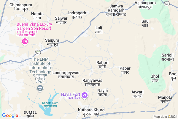
Roopwas
Roopwas Map
EDIT Map
Add Your House
 ..
..
Current Corona Virus Infected Patients Count in Jaipur District
| City Name | District Name | Total Covid cases |
|---|---|---|
| Jaipur District | Jaipur | 783 |
| Ramganj | Jaipur | 15 |
| Jaipur | Jaipur | 7 |
| Shastrinagar | Jaipur | 2 |
| Ghat Gate | Jaipur | 1 |
Locality Name :
Roopwas
( रूपवास )
Tehsil Name : Jamwa Ramgarh
District : Jaipur
State : Rajasthan
Division : Jaipur
Language : English and Hindi, Rajasthani
Current Time 11:27 AM
Date: Tuesday , Apr 29,2025 (IST)
Time zone: IST (UTC+5:30)
Elevation / Altitude: 351 meters. Above Seal level
Telephone Code / Std Code: 01426
Assembly constituency : Jamwa Ramgarh assembly constituency
Assembly MLA : Mahendra Pal Meena
Lok Sabha constituency : Jaipur Rural parliamentary constituency
Parliament MP : COL. RAJYAVARDHAN RATHORE
Serpanch Name :
Pin Code : 302027
Post Office Name : Crpf Campus Lalwas
Commodities Prices : Jaipur(Bassi) Market / Mandi
Edit below overview about Roopwas
Edit below overview about Roopwas
OverView of Roopwas
We heard from Jagas and folklore that roopwas was a grassland before independence. In Rahori village a man bring to meenas to protect his animals from gurjars. And meenas settled here.Edit below overview about Roopwas
National Highways Reachable To Roopwas
Nationa High Way :NH48
Nationa High Way :NH21
Nationa High Way :NH48
Nationa High Way :NH21
About Roopwas
Roopwas is a Village in Jamwa Ramgarh Tehsil in Jaipur District of Rajasthan State, India. It belongs to Jaipur Division . It is located 23 KM towards East from District head quarters Jaipur. 13 KM from Jamwa Ramgarh. 20 KM from State capital Jaipur
Roopwas Pin code is 302027 and postal head office is Crpf Campus Lalwas .
Indragarh ( 4 KM ) , Papar ( 4 KM ) , Jamwa Ramgarh ( 6 KM ) , Saiwar ( 6 KM ) , Ramratanpura ( 7 KM ) are the nearby Villages to Roopwas. Roopwas is surrounded by Jaipur Tehsil towards west , Bassi Tehsil towards South , Amber Tehsil towards west , Sanganer Tehsil towards west .
Jaipur , Lalsot , Reengus , Bandikui are the near by Cities to Roopwas.
Roopwas 2011 Census Details
Roopwas Local Language is English. Roopwas Village Total population is 1436 and number of houses are 214. Female Population is 48.0%. Village literacy rate is 69.9% and the Female Literacy rate is 31.1%.
Population
| Census Parameter | Census Data |
| Total Population | 1436 |
| Total No of Houses | 214 |
| Female Population % | 48.0 % ( 689) |
| Total Literacy rate % | 69.9 % ( 1004) |
| Female Literacy rate | 31.1 % ( 446) |
| Scheduled Tribes Population % | 61.5 % ( 883) |
| Scheduled Caste Population % | 8.6 % ( 123) |
| Working Population % | 46.6 % |
| Child(0 -6) Population by 2011 | 238 |
| Girl Child(0 -6) Population % by 2011 | 46.6 % ( 111) |
Roopwas Census More Deatils.
Politics in Roopwas
BJP , BSP , INC are the major political parties in this area.Polling Stations /Booths near Roopwas
1)Government Secondary School Right Part Thali2)Government Secondary School Roopwas Room No. 07
3)Govt. Primay School Booj
4)Government Adrash Primary School Tala Room No 03
5)Government Higher Secondary School Nayla Room No. 17
HOW TO REACH Roopwas
By Rail
There is no railway station near to Roopwas in less than 10 km.Colleges near Roopwas
Shree Minesh P G College Jamwa Ramgarh
Address :
Shri Minesh P. G .college
Address :
Aadarsh Mahayidyalaya, Andhi
Address :
Arya College Of Eng. & Technology
Address :
Jaipur Institute For Integrated Learning In Management
Address : A-3, “aashirwad”, Bhawani Singh Marg,jaipur , Raja
Schools near Roopwas
Love-kus Acadmy
Address : BUS STAND DHULARAWJI
Nehru Jyoti Senior Secondary School Natata
Address : Main bus stand natata
Santosh Public Sec. School
Address : NEAR PATHAN BABA MANDIR NATATA JAIPUR
Govt Primery School Rasawala
Address : Rasawala
Govt Health Centers near Roopwas
1) Kuthara kala , Kuthara kala , , school2) Kuthara Khurd , Kuthara Khurd , , SCHOOL
3) Sumel , Subcenter , ,
Hospitals in Roopwas,Jamwa Ramgarh
Bajrang Clinic
Heerawala; Jaipur; SH-55; Jaipur Road; Jaipur; Jaipur; Rajasthan 303301; India
3.3 KM distance Detail
Pavitra Clinic Life Care Center
Chainpura; Jaipur; SH-55; Jaipur Road; Jaipur; Jaipur; Rajasthan 303301; India
4.9 KM distance Detail
more ..
Petrol Bunks in Roopwas,Jamwa Ramgarh
Indian Oil Petrol Pump
RJ SH 55; Kunda; Amer; Saipura; Rajasthan 302027; India
7.2 KM distance Detail
Saini Service Station Bharat Petrol Pump Jamwa Ramgarh
Jamwa Ramgarh; Rajasthan 303104; India
8.0 KM distance Detail
Anand Filling-Bharat Petroleum
Jamuva Ragnar; Jaipur; SH-55; Jaipur Road; Jamwa Ramgarh; Jamwa Ramgarh; Rajasthan 303109; India
8.0 KM distance Detail
more ..
Colleges in Roopwas,Jamwa Ramgarh
Gendi Devi Shikshan Santhan Jaipur
Jamwa Ramgarh Rd; Rampurawas Ramgarh; Rajasthan 302027; India
2.9 KM distance Detail
SSS TT College Jamwa Ramgarh
Jamwa Ramgarh Rd; Rampurawas Ramgarh; Rajasthan 302027; India
2.9 KM distance Detail
more ..
Electronic Shops in Roopwas,Jamwa Ramgarh
shidhi vinayak DJ sound
RJ SH 55; Chak Mala Ki Nangal; Rajasthan 302027; India
3.2 KM distance Detail
Local Parks in Roopwas,Jamwa Ramgarh
LNMIIT HillTop
The LNM Institute of Information Technology; Rupa ki Nangal; Post-Sumel via -302031; Jamdoli; Jaipur; Rajasthan 302027; India
7.9 KM distance Detail
Police Stations near Roopwas,Jamwa Ramgarh
Police Station Saaipura
Saaipura; Jaipur; SH-55; Jaipur Road; Jaipur; Jaipur; Rajasthan 303301; India
7.6 KM distance Detail
LNMIIT Police Chowki
Sumel; Beermalpura at Mukandpura; Rajasthan 302027; India
7.9 KM distance Detail
Governement Offices near Roopwas,Jamwa Ramgarh
Dr. B.R.Ambedkar foundation ( Ambedkar peeth )
Moondla; Rajasthan 302027; India
1.9 KM distance Detail
About Roopwas &
History
How to reach Roopwas
Tourist Places Near By Roopwas
Schools in Roopwas
Colleges in Roopwas
Temperature & weather of Roopwas
places in Roopwas
Roopwas photos
More Information
How to reach Roopwas
Tourist Places Near By Roopwas
Schools in Roopwas
Colleges in Roopwas
Temperature & weather of Roopwas
places in Roopwas
Roopwas photos
More Information
Village Talk
Post News or Events about this Village
Near Cities
Jaipur 18 KM near
Lalsot 64 KM near
Reengus 65 KM near
Bandikui 65 KM near
Jaipur 18 KM near
Lalsot 64 KM near
Reengus 65 KM near
Bandikui 65 KM near
Near By Taluks
Jamwa Ramgarh 13 KM near
Jaipur 22 KM near
Bassi 23 KM near
Amber 26 KM near
Jamwa Ramgarh 13 KM near
Jaipur 22 KM near
Bassi 23 KM near
Amber 26 KM near
Near By Air Ports
Sanganeer Airport 27 KM near
Kheria Airport 221 KM near
Indira Gandhi International Airport 232 KM near
Gwalior Airport 264 KM near
Sanganeer Airport 27 KM near
Kheria Airport 221 KM near
Indira Gandhi International Airport 232 KM near
Gwalior Airport 264 KM near
Near By Tourist Places
Jamwa Ramgarh 7 KM near
Galta 15 KM near
Jantar Mantar 18 KM near
Jaipur 21 KM near
Samode 34 KM near
Jamwa Ramgarh 7 KM near
Galta 15 KM near
Jantar Mantar 18 KM near
Jaipur 21 KM near
Samode 34 KM near
Near By Districts
Jaipur 22 KM near
Dausa 40 KM near
Tonk 101 KM near
Alwar 101 KM near
Jaipur 22 KM near
Dausa 40 KM near
Tonk 101 KM near
Alwar 101 KM near
Near By RailWay Station
Jaipur Junction Rail Way Station 22 KM near
Getor Jagatpura Rail Way Station 23 KM near
Jaipur Junction Rail Way Station 22 KM near
Getor Jagatpura Rail Way Station 23 KM near