| Home | City Bus | Maps | Villages | Cities | Rail | Tourist Places | School | College | Pin Codes | Corona Cases Count |
| Distance Calculator Bus Services IFSC Codes Trace Mobile Number Weather Search Place Trace IP Available Cash ATM/Banks Locate Polling Booth Report an Error contact People |
Seula
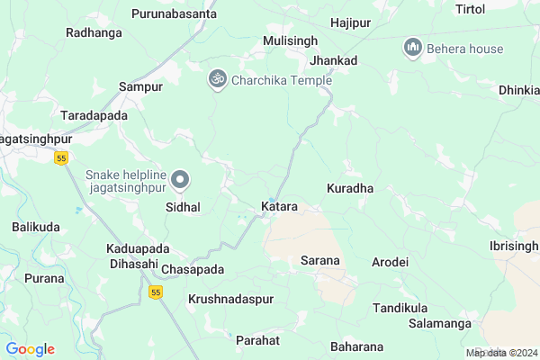
Seula Map
EDIT Map
Add Your House
 ..
..
Current Corona Virus Infected Patients Count in Jagatsinghapur District
| City Name | District Name | Total Covid cases |
|---|
Locality Name :
Seula
( ଶେଉଳ )
Tehsil Name : Tirtol
District : Jagatsinghapur
State : Odisha
Language : Oriya and Hindi,
Current Time 07:12 PM
Date: Thursday , Apr 24,2025 (IST)
Time zone: IST (UTC+5:30)
Elevation / Altitude: 8 meters. Above Seal level
Telephone Code / Std Code: 06725
Assembly constituency : Tirtol assembly constituency
Assembly MLA : rajashree mallick
Lok Sabha constituency : Jagatsinghpur parliamentary constituency
Parliament MP : RAJASHREE MALLICK
Serpanch Name :
Pin Code : 754106
Post Office Name : Kaduapada
Commodities Prices : Jagatsinghpur Market / Mandi
Seula Live Weather
Temperature: 33.6 °C
clear sky
Humidity: 53%
Wind : 8.55 mt/sec towards S
StationName : "Jagatsinghapur"
observed on 2 Hours Back
Temperature: 33.6 °C
clear sky
Humidity: 53%
Wind : 8.55 mt/sec towards S
StationName : "Jagatsinghapur"
observed on 2 Hours Back
Seula Weather Forecast for Next 5 days
25-04-2025
28.0°C to 31.2°C
clear sky, few clouds
28.0°C to 31.2°C
clear sky, few clouds
26-04-2025
27.4°C to 37.4°C
clear sky, few clouds
27.4°C to 37.4°C
clear sky, few clouds
27-04-2025
27.4°C to 36.0°C
few clouds, clear sky, scattered clouds, broken clouds
27.4°C to 36.0°C
few clouds, clear sky, scattered clouds, broken clouds
28-04-2025
27.7°C to 37.1°C
broken clouds, few clouds, clear sky, scattered clouds
27.7°C to 37.1°C
broken clouds, few clouds, clear sky, scattered clouds
29-04-2025
26.6°C to 36.7°C
broken clouds, overcast clouds, light rain, scattered clouds
26.6°C to 36.7°C
broken clouds, overcast clouds, light rain, scattered clouds
National Highways Reachable To Seula
Nationa High Way :NH316
Nationa High Way :NH53
Nationa High Way :NH316
Nationa High Way :NH53
Rivers Near Seula
Brahmani :Брагмані
Ramlala
Brahmani :Брагмані
Ramlala
About Seula
Correct below Info and add more info about SeulaSeula is a small Village/hamlet in Tirtol Tehsil in Jagatsinghapur District of Odisha State, India. It is located 12 KM towards East from District head quarters Jagatsinghpur. 7 KM from Tirtol. 52 KM from State capital Bhubaneswar
Seula Pin code is 754106 and postal head office is Kaduapada .
Susanga ( 1 KM ) , Katara ( 1 KM ) , Begunia ( 1 KM ) , Katara ( 1 KM ) , Nasika ( 1 KM ) are the nearby Villages to Seula. Seula is surrounded by Jagatsinghpur Tehsil towards west , Raghunathpur Tehsil towards North , Balikuda Tehsil towards South , Erasama Tehsil towards East .
Jagatsinghapur , Kendrapara , Paradip , Cuttack are the near by Cities to Seula.
This Place is in the border of the Jagatsinghapur District and Kendrapara District. Kendrapara District Garadapur is North towards this place .
Seula 2011 Census Details
Seula Local Language is Oriya. Seula Village Total population is 233 and number of houses are 69. Female Population is 51.5%. Village literacy rate is 71.2% and the Female Literacy rate is 33.0%.
Population
| Census Parameter | Census Data |
| Total Population | 233 |
| Total No of Houses | 69 |
| Female Population % | 51.5 % ( 120) |
| Total Literacy rate % | 71.2 % ( 166) |
| Female Literacy rate | 33.0 % ( 77) |
| Scheduled Tribes Population % | 0.0 % ( 0) |
| Scheduled Caste Population % | 12.4 % ( 29) |
| Working Population % | 37.8 % |
| Child(0 -6) Population by 2011 | 22 |
| Girl Child(0 -6) Population % by 2011 | 59.1 % ( 13) |
Seula Census More Deatils.
Politics in Seula
BJD , INC are the major political parties in this area.Polling Stations /Booths near Seula
1)Jagdish Panchagram. U.p. School Khandasahi(e)2)Patenigan Pry. School
3)Sulochana U.p. School Kantapada
4)Maheswar U.p. School
5)Barahapur Pry School (w)
HOW TO REACH Seula
By Rail
Jhankad Sarala Road Rail Way Station , Gorakhnath Rail Way Station are the very nearby railway stations to Seula.Colleges near Seula
Shree Jagannath Mohavidyalaya,naugaon Hat
Address :
Ssj Mahavidyalaya,erasama
Address :
B.b.mohavidyalaya,goda
Address : At.goda Ps,erasama Pan.754110
Sara Maha Vidyalaya,rahama
Address :
Sarala Maha Vidyalaya, Rahama
Address :
Schools in Seula
Seula Pry. School
Address : seula , tirtol , jagatsinghpur , Sikkim . PIN- 754106 , Post - Kaduapada
Govt Health Centers near Seula
1) Gardapur PHC(N) , , Patkura , Near Patkura Block Office2) NAGASPUR , , , Nagaspur Chhak
3) ORTI , , , Orti PHC (New)
Petrol Bunks in Seula,Tirtol
OMM FILLING STATION
SAMPUR-JAGATSINGHPUR; Jagatsinghpur; Odisha 754104; India
7.5 KM distance Detail
HP PETROL PUMP - KRISHNA FILLING STATION
AT: Diasahi P.O.: Kaduapada; Bhubaneshwar; Odisha 754106; India
7.5 KM distance Detail
more ..
Super Markets in Seula,Tirtol
TATA Motors Authorised Service Centre
SH 43; Jagatsinghpur; Odisha 754103; India
10.0 KM distance Detail
Governement Offices near Seula,Tirtol
Regional Transport Office (RTO) Jagatsinghpur
; Radhangabada; Odisha 754104; India
7.6 KM distance Detail
About Seula &
History
How to reach Seula
Tourist Places Near By Seula
Schools in Seula
Colleges in Seula
Temperature & weather of Seula
places in Seula
Seula photos
More Information
How to reach Seula
Tourist Places Near By Seula
Schools in Seula
Colleges in Seula
Temperature & weather of Seula
places in Seula
Seula photos
More Information
Village Talk
Post News or Events about this Village
Near Cities
Jagatsinghapur 12 KM near
Kendrapara 36 KM near
Paradip 42 KM near
Cuttack 52 KM near
Jagatsinghapur 12 KM near
Kendrapara 36 KM near
Paradip 42 KM near
Cuttack 52 KM near
Near By Taluks
Tirtol 7 KM near
Jagatsinghpur 8 KM near
Raghunathpur 13 KM near
Balikuda 14 KM near
Tirtol 7 KM near
Jagatsinghpur 8 KM near
Raghunathpur 13 KM near
Balikuda 14 KM near
Near By Air Ports
Bhubaneswar Airport 52 KM near
Netaji Subhas Chandra Bose Airport 391 KM near
Ranchi Airport 398 KM near
Vishakhapatnam Airport 475 KM near
Bhubaneswar Airport 52 KM near
Netaji Subhas Chandra Bose Airport 391 KM near
Ranchi Airport 398 KM near
Vishakhapatnam Airport 475 KM near
Near By Tourist Places
Paradeep Beach 42 KM near
Konark 48 KM near
Bhubaneswar 52 KM near
Cuttack 53 KM near
Nandan Kanan National Park 56 KM near
Paradeep Beach 42 KM near
Konark 48 KM near
Bhubaneswar 52 KM near
Cuttack 53 KM near
Nandan Kanan National Park 56 KM near
Near By Districts
Jagatsinghapur 11 KM near
Kendrapara 37 KM near
Cuttack 53 KM near
Khordha 53 KM near
Jagatsinghapur 11 KM near
Kendrapara 37 KM near
Cuttack 53 KM near
Khordha 53 KM near
Near By RailWay Station
Jhankad Sarala Road Rail Way Station 7.9 KM near
Gorakhnath Rail Way Station 8.9 KM near
Bhubaneswar Rail Way Station 49 KM near
Mancheswar Rail Way Station 50 KM near
Jhankad Sarala Road Rail Way Station 7.9 KM near
Gorakhnath Rail Way Station 8.9 KM near
Bhubaneswar Rail Way Station 49 KM near
Mancheswar Rail Way Station 50 KM near