| Home | City Bus | Maps | Villages | Cities | Rail | Tourist Places | School | College | Pin Codes | Corona Cases Count |
| Distance Calculator Bus Services IFSC Codes Trace Mobile Number Weather Search Place Trace IP Available Cash ATM/Banks Locate Polling Booth Report an Error contact People |
Sasan
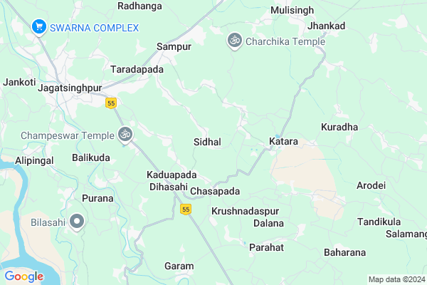
Sasan Map
EDIT Map
Add Your House
 ..
..
Current Corona Virus Infected Patients Count in Jagatsinghapur District
| City Name | District Name | Total Covid cases |
|---|
Locality Name :
Sasan
( ଶାସନ )
Tehsil Name : Jagatsinghpur
District : Jagatsinghapur
State : Odisha
Language : Oriya and Hindi,
Current Time 04:19 PM
Date: Wednesday , Feb 05,2025 (IST)
Time zone: IST (UTC+5:30)
Elevation / Altitude: 14 meters. Above Seal level
Telephone Code / Std Code: 06724
Assembly constituency : Jagatsinghpur assembly constituency
Assembly MLA : chiranjib biswal
Lok Sabha constituency : Jagatsinghpur parliamentary constituency
Parliament MP : RAJASHREE MALLICK
Serpanch Name :
Commodities Prices : Jagatsinghpur Market / Mandi
National Highways Reachable To Sasan
Nationa High Way :NH316
Nationa High Way :NH53
Nationa High Way :NH316
Nationa High Way :NH53
Rivers Near Sasan
Brahmani :Брагмані
Rana
Brahmani :Брагмані
Rana
About Sasan
Correct below Info and add more info about SasanSasan is a small Village/hamlet in Jagatsinghpur Tehsil in Jagatsinghapur District of Odisha State, India. It is located 9 KM towards East from District head quarters Jagatsinghpur. 6 KM from Jagatsinghpur. 48 KM from State capital Bhubaneswar
Chasapada ( 2 KM ) , Kaduapada ( 2 KM ) , Dihasahi ( 2 KM ) , Kotian ( 3 KM ) , Barang ( 3 KM ) are the nearby Villages to Sasan. Sasan is surrounded by Tirtol Tehsil towards East , Raghunathpur Tehsil towards North , Balikuda Tehsil towards South , Naugaon Tehsil towards South .
Jagatsinghapur , Kendrapara , Paradip , Bhubaneswar are the near by Cities to Sasan.
This Place is in the border of the Jagatsinghapur District and Cuttack District. Cuttack District Niali is west towards this place .
Sasan 2011 Census Details
Sasan Local Language is Oriya. Sasan Village Total population is 431 and number of houses are 80. Female Population is 46.6%. Village literacy rate is 76.8% and the Female Literacy rate is 33.9%.
Population
| Census Parameter | Census Data |
| Total Population | 431 |
| Total No of Houses | 80 |
| Female Population % | 46.6 % ( 201) |
| Total Literacy rate % | 76.8 % ( 331) |
| Female Literacy rate | 33.9 % ( 146) |
| Scheduled Tribes Population % | 0.9 % ( 4) |
| Scheduled Caste Population % | 15.1 % ( 65) |
| Working Population % | 33.9 % |
| Child(0 -6) Population by 2011 | 42 |
| Girl Child(0 -6) Population % by 2011 | 40.5 % ( 17) |
Sasan Census More Deatils.
Politics in Sasan
BJD , INC are the major political parties in this area.Polling Stations /Booths near Sasan
1)Daskud Pry School2)Kalioda U.p. School Koliada
3)Jualia Pry. School (n)
4)Gothada U.p. School
5)Kankadurga U.p School Piteipur (w)
HOW TO REACH Sasan
By Rail
Gorakhnath Rail Way Station is the very nearby railway stations to Sasan.Pincodes near Sasan
754106 ( Kaduapada ) , 754103 ( Jagatsinghpur ) , 754107 ( Alanahat )Colleges near Sasan
Swami Vivekananda Memorial College
Address : Jagatsinghpur - 754103 (orissa)
Schools near Sasan
Sudhananda Vidyalaya
Address : ward no. 05 , jagatsinghpur mplt , jagatsinghpur , Sikkim . PIN- 754103 , Post - Jagatsinghpur
St. Xavier School
Address : ward no. 21 , jagatsinghpur mplt , jagatsinghpur , Sikkim . PIN- 754103 , Post - Jagatsinghpur
Biju Pattnaik Smruti V.p.
Address : patenigaon , jagatsinghpur , jagatsinghpur , Sikkim . PIN- 754114 , Post - Mandasahi
Maa Ambika Adibasi Harijan Sevashra
Address : sidhal , jagatsinghpur , jagatsinghpur , Sikkim . PIN- 754106 , Post - Kaduapada
Govt Health Centers near Sasan
1) Tarasahi , Ichhapur , Ichhapur , Ichhapur PANCHAYAT OFFICE2) NAGASPUR , , , Nagaspur Chhak
3) Amana Kuda , AMANAKUDA , AMANAKUDA , AMANAKUDA
Petrol Bunks in Sasan,Jagatsinghpur
HP PETROL PUMP - KRISHNA FILLING STATION
AT: Diasahi P.O.: Kaduapada; Bhubaneshwar; Odisha 754106; India
3.7 KM distance Detail
OMM FILLING STATION
SAMPUR-JAGATSINGHPUR; Jagatsinghpur; Odisha 754104; India
6.6 KM distance Detail
more ..
Super Markets in Sasan,Jagatsinghpur
TATA Motors Authorised Service Centre
SH 43; Jagatsinghpur; Odisha 754103; India
6.8 KM distance Detail
Governement Offices near Sasan,Jagatsinghpur
R. I. Office
Baniasahidhiha; Dihasahi Rd; Jagatsinghpur; Odisha 754103; India
6.6 KM distance Detail
Regional Transport Office (RTO) Jagatsinghpur
; Radhangabada; Odisha 754104; India
7.0 KM distance Detail
Nehru Yuva Kendra Sangaghana; Jagatsinghpur
Jagatsinghpur; Odisha 754103; India
7.4 KM distance Detail
About Sasan &
History
How to reach Sasan
Tourist Places Near By Sasan
Schools in Sasan
Colleges in Sasan
Temperature & weather of Sasan
places in Sasan
Sasan photos
More Information
How to reach Sasan
Tourist Places Near By Sasan
Schools in Sasan
Colleges in Sasan
Temperature & weather of Sasan
places in Sasan
Sasan photos
More Information
Village Talk
Post News or Events about this Village
Near Cities
Jagatsinghapur 9 KM near
Kendrapara 39 KM near
Paradip 45 KM near
Bhubaneswar 50 KM near
Jagatsinghapur 9 KM near
Kendrapara 39 KM near
Paradip 45 KM near
Bhubaneswar 50 KM near
Near By Taluks
Jagatsinghpur 5 KM near
Tirtol 10 KM near
Raghunathpur 13 KM near
Balikuda 14 KM near
Jagatsinghpur 5 KM near
Tirtol 10 KM near
Raghunathpur 13 KM near
Balikuda 14 KM near
Near By Air Ports
Bhubaneswar Airport 49 KM near
Netaji Subhas Chandra Bose Airport 394 KM near
Ranchi Airport 398 KM near
Vishakhapatnam Airport 472 KM near
Bhubaneswar Airport 49 KM near
Netaji Subhas Chandra Bose Airport 394 KM near
Ranchi Airport 398 KM near
Vishakhapatnam Airport 472 KM near
Near By Tourist Places
Konark 45 KM near
Paradeep Beach 45 KM near
Bhubaneswar 49 KM near
Cuttack 51 KM near
Nandan Kanan National Park 53 KM near
Konark 45 KM near
Paradeep Beach 45 KM near
Bhubaneswar 49 KM near
Cuttack 51 KM near
Nandan Kanan National Park 53 KM near
Near By Districts
Jagatsinghapur 8 KM near
Kendrapara 40 KM near
Khordha 50 KM near
Cuttack 51 KM near
Jagatsinghapur 8 KM near
Kendrapara 40 KM near
Khordha 50 KM near
Cuttack 51 KM near
Near By RailWay Station
Bhubaneswar Rail Way Station 46 KM near
Mancheswar Rail Way Station 47 KM near
Bhubaneswar Rail Way Station 46 KM near
Mancheswar Rail Way Station 47 KM near