| Home | City Bus | Maps | Villages | Cities | Rail | Tourist Places | School | College | Pin Codes | Corona Cases Count |
| Distance Calculator Bus Services IFSC Codes Trace Mobile Number Weather Search Place Trace IP Available Cash ATM/Banks Locate Polling Booth Report an Error contact People |
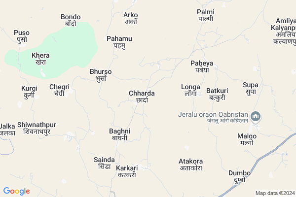
Chharda Map
EDIT Map
Add Your House
 ..
..
Current Corona Virus Infected Patients Count in Gumla District
| City Name | District Name | Total Covid cases |
|---|
Locality Name :
Chharda
( छरदा )
Block Name : Sisai
District : Gumla
State : Jharkhand
Language : Nagpuri and Hindi, Oriya, Bihari, Kurukh.
Current Time 01:53 AM
Date: Friday , Mar 14,2025 (IST)
Time zone: IST (UTC+5:30)
Elevation / Altitude: 663 meters. Above Seal level
Telephone Code / Std Code: 06523
Assembly constituency : Sisai assembly constituency
Assembly MLA : JIGA SUSARAN HORO
Lok Sabha constituency : Lohardaga parliamentary constituency
Parliament MP : SUDARSHAN BHAGAT
Serpanch Name :
Pin Code : 835324
Post Office Name : Sisai (Gumla)
Commodities Prices : Lohardaga Market / Mandi
Chharda Live Weather
Temperature: 22.3 °C
clear sky
Humidity: 24%
Wind : 2.09 mt/sec towards NW
StationName : "LohÄ\u0081rdagÄ\u0081"
observed on Now
Temperature: 22.3 °C
clear sky
Humidity: 24%
Wind : 2.09 mt/sec towards NW
StationName : "LohÄ\u0081rdagÄ\u0081"
observed on Now
Chharda Weather Forecast for Next 5 days
14-03-2025
21.8°C to 21.8°C
few clouds
21.8°C to 21.8°C
few clouds
15-03-2025
20.8°C to 37.2°C
few clouds, clear sky
20.8°C to 37.2°C
few clouds, clear sky
16-03-2025
22.8°C to 37.5°C
clear sky
22.8°C to 37.5°C
clear sky
17-03-2025
23.6°C to 37.6°C
few clouds, clear sky, broken clouds, overcast clouds
23.6°C to 37.6°C
few clouds, clear sky, broken clouds, overcast clouds
18-03-2025
23.8°C to 35.3°C
clear sky, broken clouds, scattered clouds
23.8°C to 35.3°C
clear sky, broken clouds, scattered clouds
National Highways Reachable To Chharda
Nationa High Way :NH43
Nationa High Way :NH20;NH43
Nationa High Way :NH43
Nationa High Way :NH20;NH43
Rivers Near Chharda
Bandi Koel Nadi
Sankh River :Sankh River
Bandi Koel Nadi
Sankh River :Sankh River
About Chharda
Correct below Info and add more info about ChhardaChharda is a Village in Sisai Block in Gumla District of Jharkhand State, India. It is located 38 KM towards East from District head quarters Gumla. 5 KM from Sisai. 64 KM from State capital Ranchi
Chharda Pin code is 835324 and postal head office is Sisai (Gumla).
Atakora ( 6 KM ) , Bondo ( 8 KM ) , Kudra ( 10 KM ) , Dumbo ( 10 KM ) , Bhadauli ( 10 KM ) are the nearby Villages to Chharda. Chharda is surrounded by Bharno Block towards South , Bhandra Block towards North , Lohardaga Block towards North , Senha Block towards west .
Lohardaga , Gumla , Khunti , Churi are the near by Cities to Chharda.
Chharda 2011 Census Details
Chharda Local Language is Nagpuri. Chharda Village Total population is 2947 and number of houses are 560. Female Population is 48.6%. Village literacy rate is 47.5% and the Female Literacy rate is 18.1%.
Population
| Census Parameter | Census Data |
| Total Population | 2947 |
| Total No of Houses | 560 |
| Female Population % | 48.6 % ( 1432) |
| Total Literacy rate % | 47.5 % ( 1401) |
| Female Literacy rate | 18.1 % ( 534) |
| Scheduled Tribes Population % | 67.1 % ( 1977) |
| Scheduled Caste Population % | 1.3 % ( 39) |
| Working Population % | 56.2 % |
| Child(0 -6) Population by 2011 | 416 |
| Girl Child(0 -6) Population % by 2011 | 45.7 % ( 190) |
Chharda Census More Deatils.
Politics in Chharda
Bharatiya Janata Party , BJP , JMM , INC are the major political parties in this area.Polling Stations /Booths near Chharda
1)High School Nagar Siskari2)Middle School Burhipat
3)Primary School Mahugoan
4)Primary School Malgo
5)Upgrade Middle School Lakeya
HOW TO REACH Chharda
By Rail
There is no railway station near to Chharda in less than 10 km.Colleges near Chharda
Baij Nath Jalan College
Address :
Schools in Chharda
Saraswati Shishu Vidya Mandir Chharda
Address : Village chharda dist gumla, ps sisai 835324
Govt Health Centers near Chharda
1) HSC CHHARDA , , ,2) HSC SEMRA , Govt. Building , Semra , Aganwari Center Semra
3) HSC ATAKORA , , ATAKORA ,
Sub Villages in Chharda
Petrol Bunks in Chharda,Sisai
RAJEEV AUTO SERVICE
ASRO;NH23;DISTRICT RANCHI; RANCHI; Jharkhand 835202; India
13.8 KM distance Detail
Yashraj Automobiles
Bhandra - Lohardaga Rd; Bhainsmundoalias Bhaiyagaon; Jharkhand 835324; India
14.6 KM distance Detail
more ..
About Chharda &
History
How to reach Chharda
Tourist Places Near By Chharda
Schools in Chharda
Colleges in Chharda
Temperature & weather of Chharda
places in Chharda
Chharda photos
More Information
How to reach Chharda
Tourist Places Near By Chharda
Schools in Chharda
Colleges in Chharda
Temperature & weather of Chharda
places in Chharda
Chharda photos
More Information
Village Talk
Post News or Events about this Village
Near Cities
Lohardaga 25 KM near
Gumla 37 KM near
Khunti 61 KM near
Churi 61 KM near
Lohardaga 25 KM near
Gumla 37 KM near
Khunti 61 KM near
Churi 61 KM near
Near By Taluks
Sisai 5 KM near
Bharno 10 KM near
Bhandra 15 KM near
Lohardaga 25 KM near
Sisai 5 KM near
Bharno 10 KM near
Bhandra 15 KM near
Lohardaga 25 KM near
Near By Air Ports
Ranchi Airport 62 KM near
Gaya Airport 187 KM near
Patna Airport 294 KM near
Varanasi Airport 350 KM near
Ranchi Airport 62 KM near
Gaya Airport 187 KM near
Patna Airport 294 KM near
Varanasi Airport 350 KM near
Near By Tourist Places
Lohardaga 25 KM near
Gumla 37 KM near
Chotanagpur 40 KM near
Ranchi 61 KM near
Netarhat 63 KM near
Lohardaga 25 KM near
Gumla 37 KM near
Chotanagpur 40 KM near
Ranchi 61 KM near
Netarhat 63 KM near
Near By Districts
Lohardaga 25 KM near
Gumla 37 KM near
Khunti 61 KM near
Ranchi 62 KM near
Lohardaga 25 KM near
Gumla 37 KM near
Khunti 61 KM near
Ranchi 62 KM near
Near By RailWay Station
Tori Junction Rail Way Station 53 KM near
Khalari Rail Way Station 55 KM near
Tori Junction Rail Way Station 53 KM near
Khalari Rail Way Station 55 KM near