| Home | City Bus | Maps | Villages | Cities | Rail | Tourist Places | School | College | Pin Codes | Corona Cases Count |
| Distance Calculator Bus Services IFSC Codes Trace Mobile Number Weather Search Place Trace IP Available Cash ATM/Banks Locate Polling Booth Report an Error contact People |
 ..
..
Current Corona Virus Infected Patients Count in Ghazipur District
| City Name | District Name | Total Covid cases |
|---|---|---|
| Ghazipur District | Ghazipur | 8 |
Block Name : Varachakwar
District : Ghazipur
State : Uttar Pradesh
Division : Varanasi
Language : Hindi and Urdu, Bhojpuri
Current Time 03:48 PM
Date: Wednesday , Apr 30,2025 (IST)
Time zone: IST (UTC+5:30)
Elevation / Altitude: 69 meters. Above Seal level
Telephone Code / Std Code: 05496
Assembly constituency : Zahoorabad assembly constituency
Assembly MLA : Om Prakash Rajbhar
Lok Sabha constituency : Ballia parliamentary constituency
Parliament MP : Virendra Singh
Serpanch Name :
Pin Code : 233229
Post Office Name : Barachawar
Commodities Prices : Rasda Market / Mandi
Temperature: 37.5 °C
clear sky
Humidity: 20%
Wind : 2.83 mt/sec towards E
StationName : "RasrÄ\u0081"
observed on 35 Mins Back
30.0°C to 37.2°C
clear sky, scattered clouds
28.5°C to 38.6°C
scattered clouds, few clouds, clear sky, light rain, broken clouds
26.5°C to 39.2°C
few clouds, clear sky, broken clouds
28.9°C to 41.3°C
scattered clouds, clear sky, few clouds
30.5°C to 43.1°C
few clouds, light rain, clear sky, scattered clouds
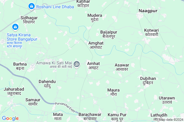
OverView of Amhat
Amhat
is the only one village in the barachawar mandal. This village is situated on
the road this village coming under the ghazipur district.
This village market is very big and beautiful market. You get every thing in this market. This village have many engineers, police, faujiand many doctors, This village 1.2 km is amwa singh village this village is in the very famous very beautiful sati maa mandir
This village have many schools but the d s convent school is the best school in the amhat village D s convent principal name is shri surya paratap singh. Amhat village 1 km is law and engenearing collage
Edit below overview about Amhat
Ganga :Ganges :ጋንጅስ :Río Gangas :نهر الغانج :গঙ্গা নদী :Qanq :Рака Ганг :Ганг :গঙ্গা নদী :གླང་ཆེན་ཁ་བབས། :Ganga :Ganges :Ganges :Ganga :Afon Ganga :Ganges :Ganges :ގަންގާ ކޯރު :Γάγγης :Ganges :Gango :Ganges :Ganges :Ganges :گنگ (رود) :Ganges :Gange :An Ghainséis :Río Ganxes :ગંગા :גנגס :गंगा :Ganges :Gangesz :Գանգես :Fluvio Ganges :Sungai Gangga :Ganges :Gange :ガンジス川 :Kali Gangga :განგი :Ганг :ಗಂಗಾ :갠지스 강 :Ganj :Ganges :Ganges :Ganges :Ganga :Ganga :Ганг :ഗംഗാനദി :गंगा :Sungai Ganges :ဂင်္ဂါမြစ် :गंगा नदी :Ganges :Ganges :Ganges :Ganges :ଗଙ୍ଗା ନଦୀ :ਗੰਗਾ ਦਰਿਆ :Ganges :Rio Ganges :Gange :Ганг :गङ्गा :Ganga :Ganges :Ганг :Ganges :Ganga :கங்கை :గంగా నది :Дарёи Гангес :แม่น้ำคงคา :Gang :Ilog Ganges :Ganj Nehri :Ганг :دریائے گنگا :Sông Hằng :גאנגעס :恒河
Tamasa
About Amhat
Amhat is a Village in Varachakwar Block in Ghazipur District of Uttar Pradesh State, India. It belongs to Varanasi Division . It is located 36 KM towards East from District head quarters Ghazipur. 5 KM from Varachakwar. 361 KM from State capital Lucknow
Amhat Pin code is 233229 and postal head office is Barachawar .
Shiwari Khas ( 1 KM ) , Amwa Singh ( 2 KM ) , Baki Khurd ( 2 KM ) , Birsingh Pur ( 3 KM ) , Hatwar Dayal Singh ( 3 KM ) are the nearby Villages to Amhat. Amhat is surrounded by Rasra Block towards North , Kasimabad Block towards west , Mohammadabad Block towards South , Chilkahar Block towards East .
Rasra , Buxar , Adari , Ghazipur are the near by Cities to Amhat.
This Place is in the border of the Ghazipur District and Ballia District. Ballia District Chilkahar is East towards this place .
Amhat 2011 Census Details
Amhat Local Language is Hindi. Amhat Village Total population is 3081 and number of houses are 440. Female Population is 48.3%. Village literacy rate is 56.4% and the Female Literacy rate is 23.4%.
Population
| Census Parameter | Census Data |
| Total Population | 3081 |
| Total No of Houses | 440 |
| Female Population % | 48.3 % ( 1489) |
| Total Literacy rate % | 56.4 % ( 1737) |
| Female Literacy rate | 23.4 % ( 720) |
| Scheduled Tribes Population % | 3.3 % ( 101) |
| Scheduled Caste Population % | 9.9 % ( 304) |
| Working Population % | 30.2 % |
| Child(0 -6) Population by 2011 | 468 |
| Girl Child(0 -6) Population % by 2011 | 49.1 % ( 230) |
Amhat Census More Deatils.
Politics in Amhat
BJP , SP , BSP are the major political parties in this area.Polling Stations /Booths near Amhat
1)J.h.school Amahat (e.wing)2)P.p.amawa Singh
3)P.p.mahadeva
4)J.h.school Shakkapur
5)J.h.school Alawalpur Afaga (s.wing)
HOW TO REACH Amhat
By Rail
Karimuddin Pur Rail Way Station is the very nearby railway stations to Amhat.Colleges near Amhat
Dr. M.a.ansari Inter College YusufpurSchools near Amhat
U.p.s. BarachawarGovt Health Centers near Amhat
1) Asawar , , ,2) Todarpur , , ,
3) Amahara , Amhara , amhara , Rural
Colleges in Amhat,Varachakwar
Kashi Nath Institute of Technology Ghazipur
Sanand Nagar; Banki Khurd; Barachawar; Ghazipur; Jogipur; Uttar Pradesh 233229; India
2.7 KM distance Detail
Dr Ram Manohar Lohia Digree Colage Dhotari
Ebrahimpur Dayal Simgh; Uttar Pradesh 233222; India
4.5 KM distance Detail
more ..
Schools in Amhat,Varachakwar
P.S CONVENT SCHOOL AMHAT GHAZIPUR
; Amwa Askaran; Uttar Pradesh 233229; India
0.8 KM distance Detail
Raghunath Singh Private ITI College ; Amwa
Amwa Singh; Uttar Pradesh 233229; India
1.7 KM distance Detail
Raghunath Singh Private I.T.i College Jagdishpur
Amwa Singh; Uttar Pradesh 233229; India
1.8 KM distance Detail
Super Markets in Amhat,Varachakwar
Gopal Maurya DjAllGana.In ; Diwanagi.Com. BhojpuriGyan Gk
village-gandhpa post office Bagend Jila Uttar Prdesh; Uttar Pradesh; India
9.9 KM distance Detail
Pradhan Nagar R. Y.
233225; RD Complex; U-3; Unnamed Rd; Sector 3; Avas Vikas Colony; Sikandra; Agra; Uttar Pradesh 282004; India
10.2 KM distance Detail
Governement Offices near Amhat,Varachakwar
Vishwakarma digital service center Dhendu
Dahendu; Uttar Pradesh 233222; India
6.3 KM distance Detail
सहकारी समिति परसा ग़ाज़ीपुर
Bishun Pura Urf Raghubarg; Uttar Pradesh 233301; India
15.5 KM distance Detail
Chetriye Panchayat
Rasra Kasimabad Marg; Kasimabad; Uttar Pradesh 233230; India
15.8 KM distance Detail
How to reach Amhat
Tourist Places Near By Amhat
Schools in Amhat
Colleges in Amhat
Temperature & weather of Amhat
places in Amhat
Amhat photos
More Information
Village Talk
Post News or Events about this Village
Rasra 10 KM near
Buxar 34 KM near
Adari 34 KM near
Ghazipur 36 KM near
Varachakwar 5 KM near
Rasra 10 KM near
Kasimabad 13 KM near
Mohammadabad 17 KM near
Varanasi Airport 114 KM near
Gorakhpur Airport 127 KM near
Patna Airport 145 KM near
Gaya Airport 181 KM near
Sarnath 101 KM near
Sasaram 105 KM near
Varanasi 110 KM near
Kushinagar 119 KM near
Jaunpur 126 KM near
Buxar 31 KM near
Mau 32 KM near
Ghazipur 35 KM near
Ballia 39 KM near
Rasra Rail Way Station 11 KM near
Yusufpur Rail Way Station 18 KM near