| Home | City Bus | Maps | Villages | Cities | Rail | Tourist Places | School | College | Pin Codes | Corona Cases Count |
| Distance Calculator Bus Services IFSC Codes Trace Mobile Number Weather Search Place Trace IP Available Cash ATM/Banks Locate Polling Booth Report an Error contact People |
 ..
..
Current Corona Virus Infected Patients Count in Ghaziabad District
| City Name | District Name | Total Covid cases |
|---|---|---|
| Ghaziabad District | Ghaziabad | 55 |
| Ghaziabad | Ghaziabad | 2 |
| Kaushambi | Ghaziabad | 1 |
Block Name : Hapur
District : Ghaziabad
State : Uttar Pradesh
Division : Meerut
Language : Hindi and Urdu
Current Time 01:13 PM
Date: Tuesday , Apr 29,2025 (IST)
Time zone: IST (UTC+5:30)
Elevation / Altitude: 214 meters. Above Seal level
Telephone Code / Std Code: 0122
Assembly constituency : Garhmukteshwar assembly constituency
Assembly MLA : Harendra Singh
Lok Sabha constituency : Amroha parliamentary constituency
Parliament MP : KUNWAR DANISH ALI
Serpanch Name :
Pin Code : 245201
Post Office Name : Babugarh
Alternate Village Name : Dayanapur
Commodities Prices : Siyana Market / Mandi
Temperature: 33.7 °C
clear sky
Humidity: 28%
Wind : 6.58 mt/sec towards E
StationName : "Babugarh"
observed on 2 Hours Back
28.4°C to 39.0°C
clear sky, scattered clouds
26.6°C to 41.4°C
scattered clouds, clear sky, few clouds, overcast clouds
28.9°C to 42.5°C
overcast clouds, broken clouds, clear sky
26.8°C to 41.3°C
overcast clouds, broken clouds, scattered clouds, light rain
26.2°C to 42.0°C
overcast clouds, few clouds, light rain, broken clouds
OverView of Dayanatpur
Dayanatpur is an historical village. it is formed in 1852 almost according our old people said. it was far away from any riyasat of any king before the our freedom. the culture of our village, most people spoke in hindi and main occupation of my village is agriculture it is a very small village and 90% people are educated. holi and diwali is the main festival of my village at the occation of holi people gethered a place and celebrate its pleasently. Chanadra Shekhar Sharma, he is a social reformer
Edit below overview about Dayanatpur
Nationa High Way :NH24
Nationa High Way :NH9
Bagad River
Bagad River
About Dayanatpur
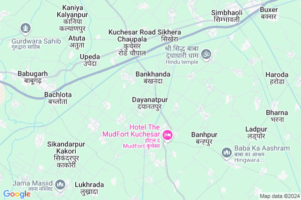
Dayanatpur is a Village in Hapur Block in Ghaziabad District of Uttar Pradesh State, India. It belongs to Meerut Division . It is located 58 KM towards East from District head quarters Ghaziabad. 16 KM from Hapur. 423 KM from State capital Lucknow
Dayanatpur Pin code is 245201 and postal head office is Babugarh .
Rasoolpur Bahlolpur ( 2 KM ) , Nali Husainpur ( 2 KM ) , Allipur Mugalpur ( 3 KM ) , Hajipur ( 3 KM ) , Shahpur Jatt ( 3 KM ) are the nearby Villages to Dayanatpur. Dayanatpur is surrounded by Bhawan Bahadur Nagar Block towards South , Hapur Block towards west , Garh Mukteshwar Block towards East , Syana Block towards East .
Hapur , Pilkhuwa , Sikandrabad , Bulandshahr are the near by Cities to Dayanatpur.
This Place is in the border of the Ghaziabad District and Meerut District. Meerut District Rajpura is North towards this place . Also it is in the Border of other district Bulandshahr .
Dayanatpur 2011 Census Details
Dayanatpur Local Language is Hindi. Dayanatpur Village Total population is 1008 and number of houses are 186. Female Population is 45.9%. Village literacy rate is 62.5% and the Female Literacy rate is 21.2%.
Population
| Census Parameter | Census Data |
| Total Population | 1008 |
| Total No of Houses | 186 |
| Female Population % | 45.9 % ( 463) |
| Total Literacy rate % | 62.5 % ( 630) |
| Female Literacy rate | 21.2 % ( 214) |
| Scheduled Tribes Population % | 0.0 % ( 0) |
| Scheduled Caste Population % | 35.0 % ( 353) |
| Working Population % | 31.6 % |
| Child(0 -6) Population by 2011 | 134 |
| Girl Child(0 -6) Population % by 2011 | 53.0 % ( 71) |
Dayanatpur Census More Deatils.
Politics in Dayanatpur
BJP , SP , BSP , INC are the major political parties in this area.Polling Stations /Booths near Dayanatpur
1)Purva Madhyamik Vidhyalaya Bankhanda R.n.-12)Prathmik Vidhyalaya Rasoolpur Bahalolpur R.n.-1
3)Prathmik Vidhyalaya Rasoolabad Nanpur R.n.2
4)Purva Madhyamik Vidhyalaya Rasoolabad Nanpur
5)Prathmik Vidhyalaya N.-1 Shikheda Muradabad
HOW TO REACH Dayanatpur
By Rail
Kuchesar Road Rail Way Station , Simbhooli Rail Way Station are the very nearby railway stations to Dayanatpur.Colleges near Dayanatpur
Gurukul Mahavidhyalaya TatarpurSchools in Dayanatpur
P.s. DayanatpurGovt Health Centers near Dayanatpur
1) Dayanatpur , Dayantpur , On Road , Rabupura Road2) PotaKabulpur , PotaKabulpur , PotaKabulpur ,
3) Kakori , rajeshwari ke ghar , Primary scholl ,
Schools in Dayanatpur,Hapur
Electronic Shops in Dayanatpur,Hapur
Super Markets in Dayanatpur,Hapur
Local Parks in Dayanatpur,Hapur
Police Stations near Dayanatpur,Hapur
Governement Offices near Dayanatpur,Hapur
How to reach Dayanatpur
Tourist Places Near By Dayanatpur
Schools in Dayanatpur
Colleges in Dayanatpur
Temperature & weather of Dayanatpur
places in Dayanatpur
Dayanatpur photos
More Information
Village Talk
Post News or Events about this Village
Hapur 16 KM near
Pilkhuwa 29 KM near
Sikandrabad 38 KM near
Bulandshahr 39 KM near
Simbhawali 7 KM near
Bhawan Bahadur Nagar 10 KM near
Hapur 15 KM near
Garh Mukteshwar 18 KM near
Indira Gandhi International Airport 92 KM near
Muzaffarnagar Airport 94 KM near
Pantnagar Airport 173 KM near
Kheria Airport 193 KM near
Bulandshahr 39 KM near
Meerut 42 KM near
Hastinapur 56 KM near
Noida 68 KM near
Surajkund 72 KM near
Bulandshahr 39 KM near
Meerut 42 KM near
Ghaziabad 56 KM near
Gautam Buddha Nagar 61 KM near
Kuchesar Road Rail Way Station 6.6 KM near
Hapur Junction Rail Way Station 16 KM near
Garhmuktesar Rail Way Station 18 KM near