| Home | City Bus | Maps | Villages | Cities | Rail | Tourist Places | School | College | Pin Codes | Corona Cases Count |
| Distance Calculator Bus Services IFSC Codes Trace Mobile Number Weather Search Place Trace IP Available Cash ATM/Banks Locate Polling Booth Report an Error contact People |
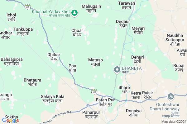
Mataso Map
EDIT Map
Add Your House
 ..
..
Current Corona Virus Infected Patients Count in Gaya District
| City Name | District Name | Total Covid cases |
|---|---|---|
| Gaya District | Gaya | 6 |
Locality Name :
Mataso
( मतस्य )
Block Name : Fatehpur
District : Gaya
State : Bihar
Division : Magadh
Language : Maithili and Hindi, Urdu, English
Current Time 11:30 AM
Date: Tuesday , Apr 29,2025 (IST)
Time zone: IST (UTC+5:30)
Elevation / Altitude: 150 meters. Above Seal level
Telephone Code / Std Code: 06322
Assembly constituency : Bodh Gaya assembly constituency
Assembly MLA : Kumar Sarvjeet
Lok Sabha constituency : Gaya parliamentary constituency
Parliament MP : Vijay Kumar
Serpanch Name :
Pin Code : 824232
Post Office Name : Fatehpur (Gaya)
Alternate Village Name : Metaso
National Highways Reachable To Mataso
Nationa High Way :NH19
Nationa High Way :NH22
Nationa High Way :NH19
Nationa High Way :NH22
Rivers Near Mataso
Sakri
Morhar
Sakri
Morhar
About Mataso
Correct below Info and add more info about MatasoMataso is a Village in Fatehpur Block in Gaya District of Bihar State, India. It belongs to Magadh Division . It is located 30 KM towards East from District head quarters Gaya. 4 KM from Fateh Pur. 122 KM from State capital Patna
Mataso Pin code is 824232 and postal head office is Fatehpur (Gaya).
Pakri ( 4 KM ) , Neemi ( 4 KM ) , Dhibar ( 4 KM ) , Bhare ( 5 KM ) , Meyari ( 7 KM ) are the nearby Villages to Mataso. Mataso is surrounded by Tankuppa Block towards west , Wazirganj Block towards North , Mescaur Block towards East , Mohanpur Block towards west .
Bodh Gaya , Gaya , Hisua , Jhumri Tilaiya are the near by Cities to Mataso.
This Place is in the border of the Gaya District and Nawada District. Nawada District Sirdala is East towards this place .
Mataso 2011 Census Details
Mataso Local Language is Maithili. Mataso Village Total population is 3433 and number of houses are 612. Female Population is 47.1%. Village literacy rate is 47.2% and the Female Literacy rate is 18.9%.
Population
| Census Parameter | Census Data |
| Total Population | 3433 |
| Total No of Houses | 612 |
| Female Population % | 47.1 % ( 1617) |
| Total Literacy rate % | 47.2 % ( 1621) |
| Female Literacy rate | 18.9 % ( 648) |
| Scheduled Tribes Population % | 0.0 % ( 0) |
| Scheduled Caste Population % | 38.1 % ( 1308) |
| Working Population % | 49.9 % |
| Child(0 -6) Population by 2011 | 646 |
| Girl Child(0 -6) Population % by 2011 | 46.4 % ( 300) |
Mataso Census More Deatils.
Politics in Mataso
LJP , BJP , Janata Dal (United) , RJD are the major political parties in this area.Polling Stations /Booths near Mataso
1)Utkramit Madhya Vidyalay Manakosi (south Part)2)Utkramit Madhya Vidyalay Naudiha Sultanapur Pu0 Bhag
3)Samudayik Vikas Bhavan Kavilapur
4)Prathamik Vidyalay Devasharana
5)Samudayik Vikas Bhavan Dadha
HOW TO REACH Mataso
By Rail
Bansinala Halt Rail Way Station , Paharpur Rail Way Station are the very nearby railway stations to Mataso. Gaya Junction Rail Way Station (near to Gaya) , Shaheed Ishwar Chowdhary Halt Rail Way Station (near to Gaya) are the Rail way stations reachable from near by towns.By Road
Gaya are the nearby by towns to Mataso having road connectivity to MatasoColleges near Mataso
Sanjay Gandhi Inter College
Address :
B.n.s.college Shobh
Address :
Upendarnath Inter Collage
Address :
Madrasa.nurulislamia.alawalpur
Address :
M G Khan College Tilora(gaya)
Address :
Schools in Mataso
P.s.halim Chak
Address : mataso , fatehpur , gaya , Bihar . PIN- 824232 , Post - Fatehpur (Gaya)
M.s.mataso
Address : mataso , fatehpur , gaya , Bihar . PIN- 824232 , Post - Fatehpur (Gaya)
Govt Health Centers near Mataso
1) Gamhari , 0 , 0 , 02) Nagwa , 0 , 0 , 0
3) Shila Pathara , , ,
Hospitals in Mataso,Fatehpur
Mehi Maharsi Aqupesor & Homio Pathik Chitiksak
SH 70; Fatehpur; Bihar 824232; India
4.7 KM distance Detail
Primary Health Centre Fatehpur
Bihar State Highway 70; Fatehpur; Bihar 824232; India
4.7 KM distance Detail
more ..
Petrol Bunks in Mataso,Fatehpur
HP PETROL PUMP - CHANDAN FUEL STATION
Mauza -raghopur; P.S.- Fatehpur Thana NO. 502; DSR &; Patna; Bihar 824232; India
3.4 KM distance Detail
more ..
Colleges in Mataso,Fatehpur
Kunti Mahadev Çharitable Trust
Near Smp College; Paharpur Station; Fatehpur; Bihar 212601; India
5.9 KM distance Detail
more ..
Schools in Mataso,Fatehpur
Aman Bharti Pustak Bhandar
Wazirganj - Fatehpur Rd; Budhaul; Bihar 805131; India
3.6 KM distance Detail
About Mataso &
History
How to reach Mataso
Tourist Places Near By Mataso
Schools in Mataso
Colleges in Mataso
Temperature & weather of Mataso
places in Mataso
Mataso photos
More Information
How to reach Mataso
Tourist Places Near By Mataso
Schools in Mataso
Colleges in Mataso
Temperature & weather of Mataso
places in Mataso
Mataso photos
More Information
Village Talk
Post News or Events about this Village
Near Cities
Bodh Gaya 24 KM near
Gaya 27 KM near
Hisua 31 KM near
Jhumri Tilaiya 46 KM near
Bodh Gaya 24 KM near
Gaya 27 KM near
Hisua 31 KM near
Jhumri Tilaiya 46 KM near
Near By Taluks
Fatehpur 4 KM near
Tankuppa 8 KM near
Wazirganj 14 KM near
Mescaur 18 KM near
Fatehpur 4 KM near
Tankuppa 8 KM near
Wazirganj 14 KM near
Mescaur 18 KM near
Near By Air Ports
Gaya Airport 31 KM near
Patna Airport 115 KM near
Ranchi Airport 168 KM near
Varanasi Airport 282 KM near
Gaya Airport 31 KM near
Patna Airport 115 KM near
Ranchi Airport 168 KM near
Varanasi Airport 282 KM near
Near By Tourist Places
Bodh Gaya 26 KM near
Kakolat 44 KM near
Koderma 46 KM near
Jhumri telaiya 47 KM near
Chatra 69 KM near
Bodh Gaya 26 KM near
Kakolat 44 KM near
Koderma 46 KM near
Jhumri telaiya 47 KM near
Chatra 69 KM near
Near By Districts
Gaya 29 KM near
Nawada 45 KM near
Koderma 50 KM near
Chatra 69 KM near
Gaya 29 KM near
Nawada 45 KM near
Koderma 50 KM near
Chatra 69 KM near
Near By RailWay Station
Bansinala Halt Rail Way Station 5.7 KM near
Paharpur Rail Way Station 5.9 KM near
Gaya Junction Rail Way Station 29 KM near
Bansinala Halt Rail Way Station 5.7 KM near
Paharpur Rail Way Station 5.9 KM near
Gaya Junction Rail Way Station 29 KM near