| Home | City Bus | Maps | Villages | Cities | Rail | Tourist Places | School | College | Pin Codes | Corona Cases Count |
| Distance Calculator Bus Services IFSC Codes Trace Mobile Number Weather Search Place Trace IP Available Cash ATM/Banks Locate Polling Booth Report an Error contact People |
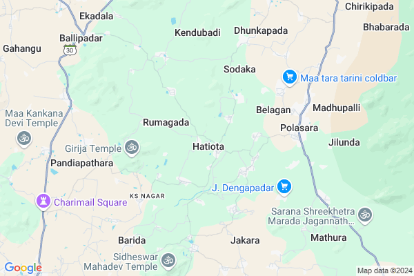
Hatiota Map
EDIT Map
Add Your House
 ..
..
Current Corona Virus Infected Patients Count in Ganjam District
| City Name | District Name | Total Covid cases |
|---|
Locality Name :
Hatiota
( ହାସଟା )
Tehsil Name : Polosara
District : Ganjam
State : Odisha
Language : Oriya and Hindi , Telugu
Current Time 10:01 AM
Date: Sunday , Apr 27,2025 (IST)
Time zone: IST (UTC+5:30)
Elevation / Altitude: 14 meters. Above Seal level
Telephone Code / Std Code: 06818
Assembly constituency : Polasara assembly constituency
Assembly MLA : srikant sahu
Lok Sabha constituency : Aska parliamentary constituency
Parliament MP : Pramila Bisoyi
Serpanch Name :
Pin Code : 761117
Post Office Name : Ballipadar
Alternate Village Name : Hatiotta
Commodities Prices : Hinjilicut Market / Mandi
Hatiota Live Weather
Temperature: 35.8 °C
broken clouds
Humidity: 30%
Wind : 3.65 mt/sec towards W
StationName : "Polasara"
observed on 39 Mins Back
Temperature: 35.8 °C
broken clouds
Humidity: 30%
Wind : 3.65 mt/sec towards W
StationName : "Polasara"
observed on 39 Mins Back
Hatiota Weather Forecast for Next 5 days
28-04-2025
28.8°C to 41.9°C
broken clouds, light rain, overcast clouds
28.8°C to 41.9°C
broken clouds, light rain, overcast clouds
29-04-2025
27.7°C to 39.6°C
broken clouds, overcast clouds, few clouds, scattered clouds
27.7°C to 39.6°C
broken clouds, overcast clouds, few clouds, scattered clouds
30-04-2025
26.5°C to 38.5°C
scattered clouds, clear sky, moderate rain, light rain, broken clouds
26.5°C to 38.5°C
scattered clouds, clear sky, moderate rain, light rain, broken clouds
01-05-2025
24.3°C to 36.7°C
few clouds, clear sky, moderate rain, heavy intensity rain, broken clouds, overcast clouds, scattered clouds
24.3°C to 36.7°C
few clouds, clear sky, moderate rain, heavy intensity rain, broken clouds, overcast clouds, scattered clouds
02-05-2025
23.2°C to 34.8°C
few clouds, clear sky, heavy intensity rain, moderate rain, light rain, broken clouds
23.2°C to 34.8°C
few clouds, clear sky, heavy intensity rain, moderate rain, light rain, broken clouds
National Highways Reachable To Hatiota
Nationa High Way :NH16
Nationa High Way :NH16
Rivers Near Hatiota
River Rushikulya
River Rushikulya
About Hatiota
Correct below Info and add more info about HatiotaHatiota is a Village in Polosara Tehsil in Ganjam District of Odisha State, India. It is located 50 KM towards North from District head quarters Chhatrapur. 6 KM from Polosara. 151 KM from State capital Bhubaneswar
Hatiota Pin code is 761117 and postal head office is Ballipadar .
Balichai ( 2 KM ) , Kalamba ( 2 KM ) , Khanduru ( 2 KM ) , Rumagada ( 2 KM ) , Dimiria ( 3 KM ) are the nearby Villages to Hatiota. Hatiota is surrounded by Kabisuryanagar Tehsil towards South , Aska Tehsil towards west , Buguda Tehsil towards North , Dharakote Tehsil towards west .
Asika , Hinjilicut , Berhampur , Brahmapur are the near by Cities to Hatiota.
Hatiota 2011 Census Details
Hatiota Local Language is Oriya. Hatiota Village Total population is 3261 and number of houses are 690. Female Population is 48.5%. Village literacy rate is 67.4% and the Female Literacy rate is 28.5%.
Population
| Census Parameter | Census Data |
| Total Population | 3261 |
| Total No of Houses | 690 |
| Female Population % | 48.5 % ( 1581) |
| Total Literacy rate % | 67.4 % ( 2197) |
| Female Literacy rate | 28.5 % ( 928) |
| Scheduled Tribes Population % | 0.0 % ( 0) |
| Scheduled Caste Population % | 7.7 % ( 250) |
| Working Population % | 33.7 % |
| Child(0 -6) Population by 2011 | 362 |
| Girl Child(0 -6) Population % by 2011 | 41.2 % ( 149) |
Hatiota Census More Deatils.
Politics in Hatiota
BJD is the major political party in this area.Polling Stations /Booths near Hatiota
1)Pry.school Ch.ramachandrapur2)Pry.school Deulapalli
3)P.u.p.school (e) Bhatakhali
4)P.u.p.school (s) Dimiria
5)P.u.p.school (s) Nimina
HOW TO REACH Hatiota
By Rail
There is no railway station near to Hatiota in less than 10 km.Colleges near Hatiota
Gandhi Group Of Institutions Berhampur
Address :
Somanath Science College, Mundamarai
Address :
Science College, Kankorada
Address :
Regional Science Collage,girisola
Address :
Anchalika Science College
Address :
Schools in Hatiota
Hatiota High School.
Address : hatiota , polasara , ganjam ,Odisha . PIN- 761117 , Post - Ballipadar
Hatiota U.p.s.
Address : hatiota , polasara , ganjam , Sikkim . PIN- 761107 , Post - Dharakote
Govt Health Centers near Hatiota
1) BHETANAI SC , near ri office , bhetanai ,2) GAHANGU SC , GAHANGU SUB CENTRE , MUNIGADI ,
3) KANDHA RANIPADA SC , KANDHA RANIPADA SC , , HILL SIDE K RANIPADA
About Hatiota &
History
How to reach Hatiota
Tourist Places Near By Hatiota
Schools in Hatiota
Colleges in Hatiota
Temperature & weather of Hatiota
places in Hatiota
Hatiota photos
More Information
How to reach Hatiota
Tourist Places Near By Hatiota
Schools in Hatiota
Colleges in Hatiota
Temperature & weather of Hatiota
places in Hatiota
Hatiota photos
More Information
Village Talk
Post News or Events about this Village
Near Cities
Asika 17 KM near
Hinjilicut 25 KM near
Berhampur 46 KM near
Brahmapur 46 KM near
Asika 17 KM near
Hinjilicut 25 KM near
Berhampur 46 KM near
Brahmapur 46 KM near
Near By Taluks
Polosara 6 KM near
Kabisuryanagar 9 KM near
Aska 13 KM near
Buguda 14 KM near
Polosara 6 KM near
Kabisuryanagar 9 KM near
Aska 13 KM near
Buguda 14 KM near
Near By Air Ports
Bhubaneswar Airport 141 KM near
Vishakhapatnam Airport 304 KM near
Raipur Airport 399 KM near
Ranchi Airport 456 KM near
Bhubaneswar Airport 141 KM near
Vishakhapatnam Airport 304 KM near
Raipur Airport 399 KM near
Ranchi Airport 456 KM near
Near By Tourist Places
Berhampur 46 KM near
Gopalpur 55 KM near
Chilika 58 KM near
Phulbani 116 KM near
Puri 125 KM near
Berhampur 46 KM near
Gopalpur 55 KM near
Chilika 58 KM near
Phulbani 116 KM near
Puri 125 KM near
Near By Districts
Ganjam 48 KM near
Nayagarh 64 KM near
Gajapati 97 KM near
Kandhamal 116 KM near
Ganjam 48 KM near
Nayagarh 64 KM near
Gajapati 97 KM near
Kandhamal 116 KM near
Near By RailWay Station
Khallikot Rail Way Station 43 KM near
Chatrapur Rail Way Station 47 KM near
Khallikot Rail Way Station 43 KM near
Chatrapur Rail Way Station 47 KM near