| Home | City Bus | Maps | Villages | Cities | Rail | Tourist Places | School | College | Pin Codes | Corona Cases Count |
| Distance Calculator Bus Services IFSC Codes Trace Mobile Number Weather Search Place Trace IP Available Cash ATM/Banks Locate Polling Booth Report an Error contact People |
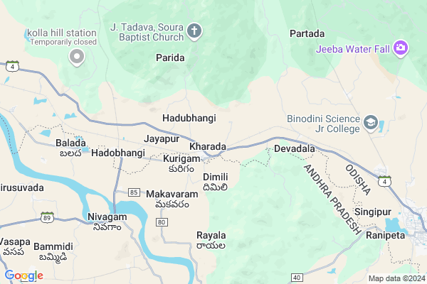
Vistala Map
EDIT Map
Add Your House
 ..
..
Current Corona Virus Infected Patients Count in Gajapati District
| City Name | District Name | Total Covid cases |
|---|
Locality Name :
Vistala
( ବିସ୍ତଲ )
Tehsil Name : Kasinagar
District : Gajapati
State : Odisha
Language : Oriya and Hindi
Current Time 11:21 AM
Date: Sunday , Apr 27,2025 (IST)
Time zone: IST (UTC+5:30)
Elevation / Altitude: 61 meters. Above Seal level
Telephone Code / Std Code: 06857
Assembly constituency : Parlakhemundi assembly constituency
Assembly MLA : kengam surya rao
Lok Sabha constituency : Berhampur parliamentary constituency
Parliament MP : CHANDRA SEKHAR SAHU
Serpanch Name :
Pin Code : 761208
Post Office Name : Kharada
Commodities Prices : Parlakhemundi Market / Mandi
Rivers Near Vistala
Vamsadhara
Gumma Gedda
Vamsadhara
Gumma Gedda
About Vistala
Correct below Info and add more info about VistalaVistala is a small Village/hamlet in Kasinagar Tehsil in Gajapati District of Odisha State, India. It is located 52 KM towards South from District head quarters Paralakhemundi. 6 KM from Kasinagar. 294 KM from State capital Bhubaneswar
Vistala Pin code is 761208 and postal head office is Kharada .
Hadubhangi ( 2 KM ) , Loba ( 4 KM ) , Tarangada ( 7 KM ) , Jeeba ( 10 KM ) , Gaiba ( 10 KM ) are the nearby Villages to Vistala. Vistala is surrounded by Kotturu Tehsil towards west , Pathapatnam Tehsil towards South , Gumma Tehsil towards North , Hiramandalam Tehsil towards South .
Parlakhemundi , Gunupur , Amadalavalasa , Palasa Kasibugga are the near by Cities to Vistala.
This Place is in the border of the Gajapati District and Srikakulam District. Srikakulam District Kotturu is west towards this place . It is near to the Andhra Pradesh State Border.
Vistala 2011 Census Details
Vistala Local Language is Oriya. Vistala Village Total population is 1485 and number of houses are 318. Female Population is 50.1%. Village literacy rate is 42.0% and the Female Literacy rate is 17.8%.
Population
| Census Parameter | Census Data |
| Total Population | 1485 |
| Total No of Houses | 318 |
| Female Population % | 50.1 % ( 744) |
| Total Literacy rate % | 42.0 % ( 624) |
| Female Literacy rate | 17.8 % ( 264) |
| Scheduled Tribes Population % | 1.8 % ( 26) |
| Scheduled Caste Population % | 7.7 % ( 115) |
| Working Population % | 52.4 % |
| Child(0 -6) Population by 2011 | 145 |
| Girl Child(0 -6) Population % by 2011 | 44.1 % ( 64) |
Vistala Census More Deatils.
Politics in Vistala
BJD , INC are the major political parties in this area.Polling Stations /Booths near Vistala
1)P.u.p. School Tuburuda2)Pry. School Mandaladevi
3)U.p. School Jeeba
4)U.p. School K.sitapur(n)
5)P.u.p.school Sidhamadanga
HOW TO REACH Vistala
By Rail
Sitapuram Halt Rail Way Station , Hadobhangi Halt Rail Way Station are the very nearby railway stations to Vistala.Colleges near Vistala
M.k.d College
Address : Gurandi Bus Stand
Centurion School Of Rural Enterprise Management
Address : R. Seethapur, Via- Uppalada, Paralakhemundi, Gajap
S.k.c.g. College
Address : Paralakhemundi, Berhampur-760007.
Jagannath Institute For Technology And Management
Address : Orissa.
Meena Ketan Degree College
Address : Gurandi, Berhampur-760007.
Schools in Vistala
Changurudu P.s.
Address : vistala , kashinagar , gajapati , Sikkim . PIN- 761208 , Post - Kharada
Govt Health Centers near Vistala
1) DHH PARALAKHEMUNDI , DHH Paralakhemundi , Paralakhemundi , Infront of CDMO Office2) SC-Judo , Judo, Sub-Center , Sahada Sector , Judo
3) SC-Akhusingi , , ,
Hospitals in Vistala,Kasinagar
Sai Krishna Medical Center
Haddubhangi Gaiba Rd; Hadobhangi; Andhra Pradesh 761208; India
5.7 KM distance Detail
more ..
Colleges in Vistala,Kasinagar
DEPARTMENT OF AGRICULTURAL ENGINEERING
CUTM; Rajaseetapuram; Odisha 761211; India
18.5 KM distance Detail
more ..
Schools in Vistala,Kasinagar
Upper Primary School;Minigam;K.sitapur;Gajapati;Odisha
Minigam -Village;K.Sitapur-Post;Gajapati-Dist;Odisha; Pedda vedi; Parlakhemundi - Kashinagar Rd; Odisha 761208; India
1.9 KM distance Detail
Electronic Shops in Vistala,Kasinagar
Laxmi Ganapathi Digitals Haddubhangi
Haddubhangi Gumma Rd; Hadobhangi; Odisha 761208; India
5.6 KM distance Detail
Mobile Point And Welding Point
Haddubhangi Gaiba Road; Khanduru; Andhra Pradesh 761208; India
5.6 KM distance Detail
Super Markets in Vistala,Kasinagar
Local Parks in Vistala,Kasinagar
About Vistala &
History
How to reach Vistala
Tourist Places Near By Vistala
Schools in Vistala
Colleges in Vistala
Temperature & weather of Vistala
places in Vistala
Vistala photos
More Information
How to reach Vistala
Tourist Places Near By Vistala
Schools in Vistala
Colleges in Vistala
Temperature & weather of Vistala
places in Vistala
Vistala photos
More Information
Village Talk
Post News or Events about this Village
Near Cities
Parlakhemundi 24 KM near
Gunupur 38 KM near
Amadalavalasa 53 KM near
Palasa Kasibugga 54 KM near
Parlakhemundi 24 KM near
Gunupur 38 KM near
Amadalavalasa 53 KM near
Palasa Kasibugga 54 KM near
Near By Taluks
Kasinagar 5 KM near
Kotturu 10 KM near
Pathapatnam 15 KM near
Gumma 16 KM near
Kasinagar 5 KM near
Kotturu 10 KM near
Pathapatnam 15 KM near
Gumma 16 KM near
Near By Air Ports
Vishakhapatnam Airport 163 KM near
Bhubaneswar Airport 278 KM near
Rajahmundry Airport 333 KM near
Raipur Airport 395 KM near
Vishakhapatnam Airport 163 KM near
Bhubaneswar Airport 278 KM near
Rajahmundry Airport 333 KM near
Raipur Airport 395 KM near
Near By Tourist Places
Berhampur 112 KM near
Vizayanagaram 113 KM near
Gopalpur 120 KM near
Araku Valley 145 KM near
Ananthagiri 145 KM near
Berhampur 112 KM near
Vizayanagaram 113 KM near
Gopalpur 120 KM near
Araku Valley 145 KM near
Ananthagiri 145 KM near
Near By Districts
Gajapati 49 KM near
Srikakulam 66 KM near
Rayagada 80 KM near
Vizianagaram 110 KM near
Gajapati 49 KM near
Srikakulam 66 KM near
Rayagada 80 KM near
Vizianagaram 110 KM near
Near By RailWay Station
Sitapuram Halt Rail Way Station 1.2 KM near
Hadobhangi Halt Rail Way Station 5.9 KM near
Naupada Junction Rail Way Station 45 KM near
Palasa Rail Way Station 51 KM near
Sitapuram Halt Rail Way Station 1.2 KM near
Hadobhangi Halt Rail Way Station 5.9 KM near
Naupada Junction Rail Way Station 45 KM near
Palasa Rail Way Station 51 KM near