| Home | City Bus | Maps | Villages | Cities | Rail | Tourist Places | School | College | Pin Codes | Corona Cases Count |
| Distance Calculator Bus Services IFSC Codes Trace Mobile Number Weather Search Place Trace IP Available Cash ATM/Banks Locate Polling Booth Report an Error contact People |
 ..
..
Current Corona Virus Infected Patients Count in Etawah District
| City Name | District Name | Total Covid cases |
|---|---|---|
| Etawah District | Etawah | 4 |
Block Name : Takha
District : Etawah
State : Uttar Pradesh
Division : Kanpur
Language : Hindi and Urdu
Current Time 09:51 AM
Date: Tuesday , Apr 29,2025 (IST)
Time zone: IST (UTC+5:30)
Elevation / Altitude: 147 meters. Above Seal level
Telephone Code / Std Code: 05680
Assembly constituency : Jaswantnagar assembly constituency
Assembly MLA : Shivpal Singh Yadav
Lok Sabha constituency : Mainpuri parliamentary constituency
Parliament MP : MULAYAM SINGH YADAV
Serpanch Name :
Pin Code : 206242
Post Office Name : Bharthana
Commodities Prices : Bharthna Market / Mandi
Temperature: 33.1 °C
broken clouds
Humidity: 26%
Wind : 6.41 mt/sec towards E
StationName : "Kishni"
observed on 23 Mins Back
29.9°C to 39.7°C
broken clouds, scattered clouds, clear sky, few clouds
27.6°C to 40.7°C
few clouds, clear sky, scattered clouds
29.5°C to 42.2°C
scattered clouds, broken clouds, overcast clouds, few clouds, clear sky
29.3°C to 42.4°C
scattered clouds, broken clouds, few clouds
29.1°C to 42.2°C
overcast clouds, scattered clouds, broken clouds
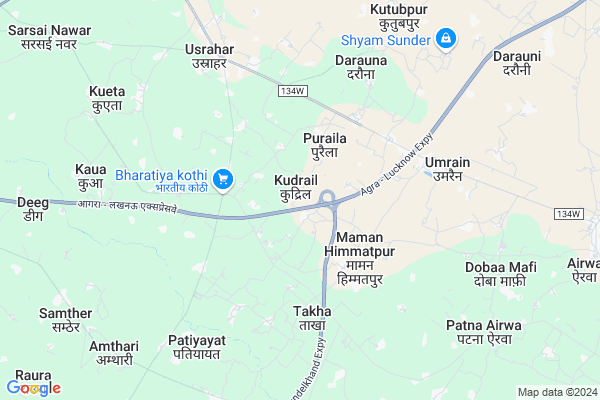
OverView of Kudrail
Kudarail is a revenue village in Bharthana Tehsil. Kudrail is a head quater of village panchayat covering Kathautiya, Nagla chatur, Narayanpura Pooranpura, Sujanpura, Keshopura, Kothe bazar, Nagla kuana, Shivra, Rampura ets. The total population of the Kudarail panchayat is about 20000. The population of kudlrail village itself is almost 8000. The village is mainly populated by brahmins ksatriyas ,Gadariya and servising coumminites. The village is having diversified culture. One third of total familes are following Muslim religion living with Hindus in harmony.
The village is famous for its mini fort know as Kudrail Garhi having 9 "burge" and a old temple Bhuiya devi and Bhumbh sen Maharaj. The village is having agrarian society mixed with sevicing coummites like carpenter, barber, kumhar, kahar, catering need of whole village panchayat. The main festivals are Holi, Depawali, Dashahra, Ramlela is a annual celebration commenced from dashahra to Depawali enjoyed by all members of society. Agahani Purnima is a great occasion for natives when colorful mela is organised annually enjoyed by all specialy by children in the campus of Bhummbh sen Maharaj Temple.
There are seven Educational institutions mainly Ganga Shanti Sarasawati Vidhya Mandir, Shainti Niketan Uchchtar madhyamik Vidhayalaya, and Primary school and Junior Kanya Vidhyalaya. The people is mainly engaged in agricultural operations, artisanal activities and in small business.
Edit below overview about Kudrail
Nationa High Way :NH34
About Kudrail
Kudrail is a Village in Takha Block in Etawah District of Uttar Pradesh State, India. It belongs to Kanpur Division . It is located 39 KM towards East from District head quarters Etawah. 4 KM from Takha. 189 KM from State capital Lucknow
Kudrail Pin code is 206242 and postal head office is Bharthana .
Nagla Gujrati ( 3 KM ) , Brahmanipur ( 3 KM ) , Maman Himmatpur ( 3 KM ) , Sonthana ( 3 KM ) , Adhini ( 4 KM ) are the nearby Villages to Kudrail. Kudrail is surrounded by Erwa Katra Block towards East , Kishni Block towards North , Saurikh Block towards East , Bharthana Block towards South .
Bharthana , Achhalda , Etawah , Sikanderpur are the near by Cities to Kudrail.
This Place is in the border of the Etawah District and Auraiya District. Auraiya District Erwa Katra is East towards this place . Also it is in the Border of other district Mainpuri .
Kudrail 2011 Census Details
Kudrail Local Language is Hindi. Kudrail Village Total population is 10818 and number of houses are 1805. Female Population is 45.6%. Village literacy rate is 62.8% and the Female Literacy rate is 24.9%.
Population
| Census Parameter | Census Data |
| Total Population | 10818 |
| Total No of Houses | 1805 |
| Female Population % | 45.6 % ( 4937) |
| Total Literacy rate % | 62.8 % ( 6790) |
| Female Literacy rate | 24.9 % ( 2696) |
| Scheduled Tribes Population % | 0.0 % ( 0) |
| Scheduled Caste Population % | 30.8 % ( 3327) |
| Working Population % | 35.0 % |
| Child(0 -6) Population by 2011 | 1642 |
| Girl Child(0 -6) Population % by 2011 | 46.2 % ( 758) |
Kudrail Census More Deatils.
Politics in Kudrail
SP , BSP , INC are the major political parties in this area.Polling Stations /Booths near Kudrail
1)Primary School Patajhari2)Primary School Patiyayat East
3)Junior High School Takha West
4)Primary School Badariyapooth
5)Primary School Bhagwanpura
HOW TO REACH Kudrail
By Rail
There is no railway station near to Kudrail in less than 10 km.Colleges near Kudrail
Nandram Ramchandra Inter College Nandgaon Takha EtawahSchools in Kudrail
Shanti Nikaten Umv KudrailGovt Health Centers near Kudrail
1) PHC Umrain , Umain , sutyani road ,2) BARAUNAKALA , subcentre barona kala , barona kala ,
3) Udaypur kala , SUB CENTRE UDAYPUR KALA , UDAYPURKALA 22098 ON MCTS , PRIMARY SCHOOL UDAYPUR KALA
Sub Villages in Kudrail
Petrol Bunks in Kudrail,Takha
LATE MALTI DEVI FILLING STATION HPCL
Village Usrahar Tehsil Bhartana District Etawah; Kanpur; Uttar Pradesh 206242; India
5.1 KM distance Detail
more ..
Colleges in Kudrail,Takha
SHREE KUWAR BHAMA JUNIOR HIGH SCHOOL BADKAN SHASHPUR
Badkan Shahpur; Uttar Pradesh 206123; India
6.5 KM distance Detail
more ..
Super Markets in Kudrail,Takha
DHL fu kvh
Kishani - Usrahar - Bharthana Road; Rudauli; Uttar Pradesh 206242; India
5.8 KM distance Detail
Police Stations near Kudrail,Takha
Police Chowki Sarsai City
hajare mahadev temple;;; Sarsai Nawar; Uttar Pradesh 206123; India
11.1 KM distance Detail
How to reach Kudrail
Tourist Places Near By Kudrail
Schools in Kudrail
Colleges in Kudrail
Temperature & weather of Kudrail
places in Kudrail
Kudrail photos
More Information
Village Talk
Post News or Events about this Village
Bharthana 16 KM near
Achhalda 26 KM near
Etawah 37 KM near
Sikanderpur 41 KM near
Takha 4 KM near
Erwa Katra 11 KM near
Kishni 18 KM near
Saurikh 20 KM near
Kanpur Airport 137 KM near
Gwalior Airport 143 KM near
Kheria Airport 153 KM near
Amausi Airport 174 KM near
Kannauj 69 KM near
Bithur 112 KM near
Kanpur 126 KM near
Agra 149 KM near
Gwalior 153 KM near
Etawah 37 KM near
Mainpuri 52 KM near
Auraiya 59 KM near
Farrukhabad 66 KM near
Bharthana Rail Way Station 22 KM near
Phaphund Rail Way Station 35 KM near