| Home | City Bus | Maps | Villages | Cities | Rail | Tourist Places | School | College | Pin Codes | Corona Cases Count |
| Distance Calculator Bus Services IFSC Codes Trace Mobile Number Weather Search Place Trace IP Available Cash ATM/Banks Locate Polling Booth Report an Error contact People |
Tarpongi
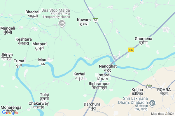
Tarpongi Map
EDIT Map
Add Your House
 ..
..
Current Corona Virus Infected Patients Count in Durg District
| City Name | District Name | Total Covid cases |
|---|---|---|
| Bhilai | Durg | 1 |
Locality Name :
Tarpongi
( तरपोंगी )
Tehsil Name : Nawagarh
District : Durg
State : Chattisgarh
Language : Chhattisgarhi and Hindi, Urdu
Current Time 12:41 PM
Date: Monday , Apr 28,2025 (IST)
Time zone: IST (UTC+5:30)
Elevation / Altitude: 283 meters. Above Seal level
Telephone Code / Std Code: 07755
Assembly constituency : Nawagarh assembly constituency
Assembly MLA : Dayaldas Baghel
Lok Sabha constituency : Durg parliamentary constituency
Parliament MP : VIJAY BAGHEL
Serpanch Name :
Pin Code : 491340
Post Office Name : Nandghat
Commodities Prices : Neora Market / Mandi
Edit below overview about Tarpongi
Edit below overview about Tarpongi
OverView of Tarpongi
Tarpongi is a beautiful village near shivnath river. There is anciant shiv mandir and big play ground. There main source of income are rice and vegetables farm.Edit below overview about Tarpongi
Rivers Near Tarpongi
Shivnath :Seonath
Lilagar
Shivnath :Seonath
Lilagar
About Tarpongi
Tarpongi is a Village in Nawagarh Tehsil in Durg District of Chattisgarh State, India. It is located 96 KM towards North from District head quarters Durg. 15 KM from Nawagarh. 70 KM from State capital Raipur
Tarpongi Pin code is 491340 and postal head office is Nandghat .
Nandghat ( 4 KM ) , Malda ( 5 KM ) , Mau ( 6 KM ) , Keshla ( 6 KM ) , Mutpuri ( 6 KM ) are the nearby Villages to Tarpongi. Tarpongi is surrounded by Nawagarh Tehsil towards North , Bemetara Tehsil towards west , Bhatapara Tehsil towards East , Pathariya Tehsil towards North .
Bhatapara , Tilda Newra , Bemetra , Mungeli are the near by Cities to Tarpongi.
This Place is in the border of the Durg District and Bilaspur District. Bilaspur District Mungeli is North towards this place .
Tarpongi 2011 Census Details
Tarpongi Local Language is Chhattisgarhi. Tarpongi Village Total population is 1699 and number of houses are 349. Female Population is 49.4%. Village literacy rate is 57.4% and the Female Literacy rate is 22.8%.
Population
| Census Parameter | Census Data |
| Total Population | 1699 |
| Total No of Houses | 349 |
| Female Population % | 49.4 % ( 840) |
| Total Literacy rate % | 57.4 % ( 976) |
| Female Literacy rate | 22.8 % ( 387) |
| Scheduled Tribes Population % | 13.7 % ( 233) |
| Scheduled Caste Population % | 10.7 % ( 182) |
| Working Population % | 47.8 % |
| Child(0 -6) Population by 2011 | 269 |
| Girl Child(0 -6) Population % by 2011 | 50.9 % ( 137) |
Tarpongi Census More Deatils.
Politics in Tarpongi
Bharatiya Janata Party , BJP , INC are the major political parties in this area.Polling Stations /Booths near Tarpongi
1)Sookhatal2)Tarapongi
3)Lavatra
4)Magaraghata
5)Dhaurabhathakala
HOW TO REACH Tarpongi
By Rail
There is no railway station near to Tarpongi in less than 10 km.Colleges near Tarpongi
Govt College Armarikala
Address :
Demo Mobile Colllege
Address :
Chhattisgarh Institute Of Management And Technology Bhilai
Address :
Gov.collage Of Art,commerce & Seince Jamgaon R
Address : Jamgaon R , Patan ,durg ,chattisgarh
Govt. College Bori Bujurg
Address : Vill & Post-bori
thana- Bori
dist- Durg
chattisgarh
pin-491001
Schools in Tarpongi
Janbhagidari Ms
Address : tarpongi , nawagarh , durg , Chattisgarh . PIN- 491340 , Post - Nandghat
Govt Health Centers near Tarpongi
1) SHC Limtara-N , , Aagan Badi Bhawan Limtara ,2) SHC Karhul , , Aagan Badi Bhawan Karhul ,
3) SHC Mau , Sub Health Center - Mau , ward 3 , Near gram panchayat
Petrol Bunks in Tarpongi,Nawagarh
HP PETROL PUMP - BAGHEL FUELS
Khasra NO. 506/2; P.H. NO. 28 Village Sambalpur Tehsil Nawagarh; Raipur; Chhattisgarh 491337; India
18.4 KM distance Detail
more ..
Schools in Tarpongi,Nawagarh
GOVERNMENT PRIMARY SCHOOL NAGDHA BLOCK NAVAGARH BEMETARA
Nagdha; Chhattisgarh 491340; India
10.2 KM distance Detail
Super Markets in Tarpongi,Nawagarh
SANTOSH KRISHI KENDRA &KHUSHI TRADERS MARO C.G
Maro; Chhattisgarh 491340; India
15.3 KM distance Detail
Local Parks in Tarpongi,Nawagarh
Police Stations near Tarpongi,Nawagarh
Governement Offices near Tarpongi,Nawagarh
About Tarpongi &
History
How to reach Tarpongi
Tourist Places Near By Tarpongi
Schools in Tarpongi
Colleges in Tarpongi
Temperature & weather of Tarpongi
places in Tarpongi
Tarpongi photos
More Information
How to reach Tarpongi
Tourist Places Near By Tarpongi
Schools in Tarpongi
Colleges in Tarpongi
Temperature & weather of Tarpongi
places in Tarpongi
Tarpongi photos
More Information
Village Talk
Post News or Events about this Village
Near Cities
Bhatapara 19 KM near
Tilda Newra 27 KM near
Bemetra 30 KM near
Mungeli 38 KM near
Bhatapara 19 KM near
Tilda Newra 27 KM near
Bemetra 30 KM near
Mungeli 38 KM near
Near By Taluks
Simga 13 KM near
Nawagarh 15 KM near
Bemetara 24 KM near
Bhatapara 25 KM near
Simga 13 KM near
Nawagarh 15 KM near
Bemetara 24 KM near
Bhatapara 25 KM near
Near By Air Ports
Raipur Airport 73 KM near
Jabalpur Airport 241 KM near
Sonegaon Airport 326 KM near
Khajuraho Airport 435 KM near
Raipur Airport 73 KM near
Jabalpur Airport 241 KM near
Sonegaon Airport 326 KM near
Khajuraho Airport 435 KM near
Near By Tourist Places
Bilaspur 56 KM near
Raipur 66 KM near
Kawardha 69 KM near
Bhilai 83 KM near
Mahasamund 90 KM near
Bilaspur 56 KM near
Raipur 66 KM near
Kawardha 69 KM near
Bhilai 83 KM near
Mahasamund 90 KM near
Near By Districts
Bilaspur 57 KM near
Raipur 68 KM near
Kabirdham 70 KM near
Mahasamund 90 KM near
Bilaspur 57 KM near
Raipur 68 KM near
Kabirdham 70 KM near
Mahasamund 90 KM near
Near By RailWay Station
Bhatapara Rail Way Station 19 KM near
Tilda Rail Way Station 27 KM near
Bhatapara Rail Way Station 19 KM near
Tilda Rail Way Station 27 KM near