| Home | City Bus | Maps | Villages | Cities | Rail | Tourist Places | School | College | Pin Codes | Corona Cases Count |
| Distance Calculator Bus Services IFSC Codes Trace Mobile Number Weather Search Place Trace IP Available Cash ATM/Banks Locate Polling Booth Report an Error contact People |
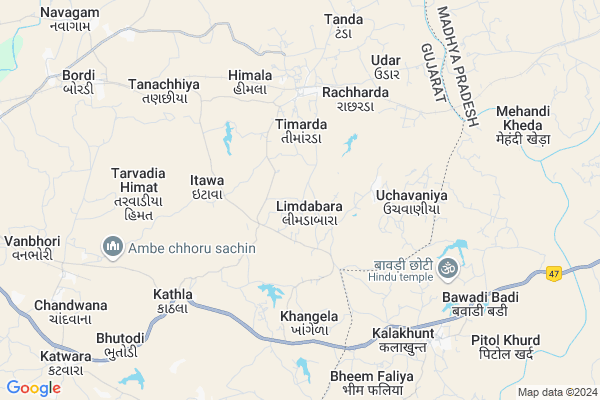
Limdabara Map
EDIT Map
Add Your House
 ..
..
Current Corona Virus Infected Patients Count in Dohad District
| City Name | District Name | Total Covid cases |
|---|
Locality Name :
Limdabara
( લીંડાબાર )
Taluka Name : Dahod
District : Dohad
State : Gujarat
Language : Gujarati and Hindi
Current Time 02:18 PM
Date: Tuesday , Apr 29,2025 (IST)
Time zone: IST (UTC+5:30)
Elevation / Altitude: 313 meters. Above Seal level
Telephone Code / Std Code: 02673
Assembly constituency : Dahod assembly constituency
Assembly MLA : Kanaiyalal Bachubhai Kishori
Lok Sabha constituency : Dahod parliamentary constituency
Parliament MP : JASHVANTSINH SUMANBHAI BHABHOR
Serpanch Name :
Pin Code : 389154
Post Office Name :
Commodities Prices : Dahod Market / Mandi
Limdabara Live Weather
Temperature: 38.7 °C
clear sky
Humidity: 12%
Wind : 7.09 mt/sec towards W
StationName : "Dohad"
observed on 2 Hours Back
Temperature: 38.7 °C
clear sky
Humidity: 12%
Wind : 7.09 mt/sec towards W
StationName : "Dohad"
observed on 2 Hours Back
Limdabara Weather Forecast for Next 5 days
30-04-2025
28.3°C to 41.9°C
clear sky
28.3°C to 41.9°C
clear sky
01-05-2025
26.5°C to 42.2°C
clear sky
26.5°C to 42.2°C
clear sky
02-05-2025
26.7°C to 42.1°C
clear sky
26.7°C to 42.1°C
clear sky
03-05-2025
26.2°C to 42.1°C
clear sky
26.2°C to 42.1°C
clear sky
04-05-2025
25.9°C to 40.6°C
clear sky
25.9°C to 40.6°C
clear sky
National Highways Reachable To Limdabara
Nationa High Way :NH47
Nationa High Way :NH47;NH56
Nationa High Way :NH47
Nationa High Way :NH47;NH56
Rivers Near Limdabara
Sunar
Pat
Sunar
Pat
About Limdabara
Correct below Info and add more info about LimdabaraLimdabara is a Village in Dahod Taluka in Dohad District of Gujarat State, India. It is located 19 KM towards East from District head quarters Dahod. 13 KM from . 218 KM from State capital Gandhinagar
Limdabara Pin code is 389154 and postal head office is .
Gundi Kheda ( 3 KM ) , Uchavaniya ( 4 KM ) , Itawa ( 4 KM ) , Khangela ( 4 KM ) , Rachharda ( 4 KM ) are the nearby Villages to Limdabara. Limdabara is surrounded by Dohad Taluka towards west , Jhabua Taluka towards East , Meghnagar Taluka towards North , Garbada Taluka towards west .
Dahod , Jhabua , Rajgarh , Banswara are the near by Cities to Limdabara.
Demographics of Limdabara
Gujarati is the Local Language here.Politics in Limdabara
Bharatiya Janata Party , BJP , INC are the major political parties in this area.Polling Stations /Booths near Limdabara
1)Kotdakhurda-22)Limdabara-2
3)Limdabara-1
4)Limdabara-3
5)Timarda-2
HOW TO REACH Limdabara
By Rail
Anas Rail Way Station , Bordi Rail Way Station are the very nearby railway stations to Limdabara.Colleges near Limdabara
P.t.c College Of Sanjeli
Address :
Govt. Engineering College, Dahod
Address : Opp. Navjivan Arts And Science College,
zalod Raod, Dahod
Arts Commence College Zalod
Address :
Government Engineering College, Dahod
Address : Opp. Navjivan Science Collegedahod-zalod Road,daho
J & R B. Ed. College
Address : Navjeevan Arts & Commerce College Campus, Jhalod R
Schools in Limdabara
Limdabara Pri.shala
Address : limdabara , dahod , dohad , Gujarat . PIN- 389151 , Post - Dahod
Govt Health Centers near Limdabara
1) Timarda , Gamtal , BUS STATION , NEAR MADHYAMIK SHALA2) Khangela , Khangela , Mota Faliya , Near Highway Road
3) Kathla , KATHLA P.H.C , NEAR PANCHAYT OFFICE , NEAR RIVER
Colleges in Limdabara,Dahod
RAHAT MEDICAL STORE
Kasba; Hamidi Moholla; Govindnagar; Dahod; Gujarat 389151; India
19.7 KM distance Detail
SMART KIDS PRESCHOOL.DAHOD.
Maimoon nagar;Saifee nagar;; Godhra Road; Vanzarwada; Dahod; Gujarat 389151; India
20.4 KM distance Detail
Gurjar Bharti B.ed. College; Nagarala
Sotiyajalam; Madhya Pradesh 457661; India
20.9 KM distance Detail
more ..
Schools in Limdabara,Dahod
Pragati High School ; Uchvaniya
NH 59; Nana Uchavaniya; Uchavaniya; Gujarat 389154; India
2.4 KM distance Detail
Local Parks in Limdabara,Dahod
Udhyan Bag Garden
Govind nagar chok; Govindnagar; Dahod; Gujarat 389151; India
18.9 KM distance Detail
Police Stations near Limdabara,Dahod
Police Chowki Ramvhapur
ashapuri colony; Rambhapur; Madhya Pradesh 457779; India
14.1 KM distance Detail
Governement Offices near Limdabara,Dahod
Nagar Seva Sadan
Wanzawad; Dahod; NH-113; Netaji Bazar Road; Dahod; Dahod; Gujarat 389151; India
19.3 KM distance Detail
About Limdabara &
History
How to reach Limdabara
Tourist Places Near By Limdabara
Schools in Limdabara
Colleges in Limdabara
Temperature & weather of Limdabara
places in Limdabara
Limdabara photos
More Information
How to reach Limdabara
Tourist Places Near By Limdabara
Schools in Limdabara
Colleges in Limdabara
Temperature & weather of Limdabara
places in Limdabara
Limdabara photos
More Information
Village Talk
Post News or Events about this Village
Near Cities
Dahod 19 KM near
Jhabua 20 KM near
Rajgarh 63 KM near
Banswara 86 KM near
Dahod 19 KM near
Jhabua 20 KM near
Rajgarh 63 KM near
Banswara 86 KM near
Near By Taluks
Dahod 12 KM near
Dohad 19 KM near
Meghnagar 20 KM near
Jhabua 20 KM near
Dahod 12 KM near
Dohad 19 KM near
Meghnagar 20 KM near
Jhabua 20 KM near
Near By Air Ports
Vadodara Airport 151 KM near
Indore Airport 160 KM near
Ahmedabad Airport 208 KM near
Dabok Airport 230 KM near
Vadodara Airport 151 KM near
Indore Airport 160 KM near
Ahmedabad Airport 208 KM near
Dabok Airport 230 KM near
Near By Tourist Places
Dahod 20 KM near
Banswara 88 KM near
Ratlam 95 KM near
Champaner 110 KM near
Pavagadh 114 KM near
Dahod 20 KM near
Banswara 88 KM near
Ratlam 95 KM near
Champaner 110 KM near
Pavagadh 114 KM near
Near By Districts
Dohad 18 KM near
Jhabua 21 KM near
Alirajpur 66 KM near
Banswara 89 KM near
Dohad 18 KM near
Jhabua 21 KM near
Alirajpur 66 KM near
Banswara 89 KM near
Near By RailWay Station
Anas Rail Way Station 4.6 KM near
Meghnagar Rail Way Station 16 KM near
Dahod Rail Way Station 19 KM near
Anas Rail Way Station 4.6 KM near
Meghnagar Rail Way Station 16 KM near
Dahod Rail Way Station 19 KM near