| Home | City Bus | Maps | Villages | Cities | Rail | Tourist Places | School | College | Pin Codes | Corona Cases Count |
| Distance Calculator Bus Services IFSC Codes Trace Mobile Number Weather Search Place Trace IP Available Cash ATM/Banks Locate Polling Booth Report an Error contact People |
 ..
..
Current Corona Virus Infected Patients Count in Deogarh District
| City Name | District Name | Total Covid cases |
|---|
Tehsil Name : Reamal
District : Deogarh
State : Odisha
Language : Oriya and Hindi
Current Time 03:20 PM
Date: Wednesday , Apr 30,2025 (IST)
Time zone: IST (UTC+5:30)
Elevation / Altitude: 197 meters. Above Seal level
Telephone Code / Std Code: 06647
Assembly constituency : Deogarh assembly constituency
Assembly MLA : nitesh gangadeb
Lok Sabha constituency : Sambalpur parliamentary constituency
Parliament MP : NITESH GANGA DEB
Serpanch Name :
Pin Code : 768109
Post Office Name : Reamal
Commodities Prices : Talcher Market / Mandi
Temperature: 38.9 °C
clear sky
Humidity: 23%
Wind : 6.14 mt/sec towards SE
StationName : "Deogarh"
observed on Now
24.5°C to 35.2°C
light rain, clear sky, few clouds
22.1°C to 39.6°C
few clouds, clear sky, light rain, moderate rain, scattered clouds
21.9°C to 39.7°C
clear sky, few clouds, scattered clouds, heavy intensity rain
24.7°C to 38.0°C
clear sky, few clouds, scattered clouds, moderate rain, broken clouds, overcast clouds
24.8°C to 41.3°C
broken clouds, scattered clouds, few clouds, clear sky, light rain
OverView of Kundheigola
The name of my village is Kundheigola. It is situated on the bank of the Tikira. The village is very old and has a number of special features.
It is believed that Goddes Bhairavi who is the village deity protects this village in all kinds of disaster. Another specialty of this village is that there is no Brahmin family here.It is a big village with 500 families. Its population is about 2000 approx. It is sixty kilometers away from the Disrtict headquarter Deogarh also same distance from Angul District. It looks green as there are many green trees in our village. The temple of Lord Jagannath is situated in the middle of the village. There are champak trees, mango trees, a few oleander trees and a big peepal tree. This part of our village presents a beautiful: it. The smell of flowers and mango buds combined with how attractive colour arrests everybody's attention.My village mostly famous for huge production of orange and parbal.Our village has a fair weather connection with the main road as N.H. 200.In spite of it our village is a developed one. There is a school with teaching facility up to the matriculation stage.
My village have a post office,a model police station, a medical.
The main occupation of our villagers is cultivation. Our village has a good name for vegetable production. The river is very helpful to our villagers. All kinds of seasonal vegetables are available in good quality and cheap price. For this reason, many vegetable merchants come to our village for collecting fresh vegetables in large quantity. However, our villagers are united and therefore they are seldom influenced by the foreign merchants.
The villagers do not differ on any issue. If at all there is a dispute, they sit together and settle it amicably.
Edit below overview about Kundheigola
Nationa High Way :NH53
Brahmani :Brahmani :Брагмані
Mankarha
About Kundheigola
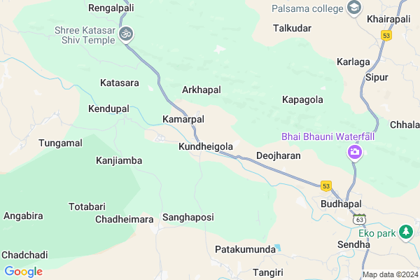
Kundheigola is a Village in Reamal Tehsil in Deogarh District of Odisha State, India. It is located 44 KM towards South from District head quarters Debagarh. 21 KM from Reamal. 175 KM from State capital Bhubaneswar
Kundheigola Pin code is 768109 and postal head office is Reamal .
Budhapal ( 8 KM ) , Utunia ( 9 KM ) , Karlaga ( 10 KM ) , Para ( 12 KM ) , Palsama ( 13 KM ) are the nearby Villages to Kundheigola. Kundheigola is surrounded by Chhendipada Tehsil towards South , Kaniha Tehsil towards East , Naktideul Tehsil towards west , Deogarh Tehsil towards North .
Debagarh , Talcher , Anugul , Kuchinda are the near by Cities to Kundheigola.
This Place is in the border of the Deogarh District and Sambalpur District. Sambalpur District Naktideul is west towards this place .
Kundheigola 2011 Census Details
Kundheigola Local Language is Oriya. Kundheigola Village Total population is 1808 and number of houses are 420. Female Population is 47.3%. Village literacy rate is 68.5% and the Female Literacy rate is 26.9%.
Population
| Census Parameter | Census Data |
| Total Population | 1808 |
| Total No of Houses | 420 |
| Female Population % | 47.3 % ( 856) |
| Total Literacy rate % | 68.5 % ( 1238) |
| Female Literacy rate | 26.9 % ( 486) |
| Scheduled Tribes Population % | 9.6 % ( 173) |
| Scheduled Caste Population % | 23.9 % ( 433) |
| Working Population % | 65.9 % |
| Child(0 -6) Population by 2011 | 154 |
| Girl Child(0 -6) Population % by 2011 | 48.7 % ( 75) |
Kundheigola Census More Deatils.
Politics in Kundheigola
BJP , BJD , INC are the major political parties in this area.Polling Stations /Booths near Kundheigola
1)Kundheigola High School(e)2)Kundapitha U.g.u.p. School
3)Koradapal Pry. School
4)Kandhal Pry School (w)
5)Sampali Pry. School
HOW TO REACH Kundheigola
By Rail
There is no railway station near to Kundheigola in less than 10 km.Colleges near Kundheigola
Palsama Science CollegeSchools in Kundheigola
Kundheigola H.s.Govt Health Centers near Kundheigola
1) Hatibari , , ,2) KHAJURIA KATA , KHAJURIAKATA CHC , KHAJURIAKATA , NEAR STATE BANK OF INDIA
3) Khajurikata (Main) SC , KHAJURIAKATA , KHAJURIAKATA , KHAJURIAKATA CHC
Schools in Kundheigola,Reamal
Khairapali High School
Khairapali - Budhapal Road; Karlaga; Odisha 768109; India
10.0 KM distance Detail
Super Markets in Kundheigola,Reamal
Local Parks in Kundheigola,Reamal
Governement Offices near Kundheigola,Reamal
How to reach Kundheigola
Tourist Places Near By Kundheigola
Schools in Kundheigola
Colleges in Kundheigola
Temperature & weather of Kundheigola
places in Kundheigola
Kundheigola photos
More Information
Village Talk
Post News or Events about this Village
Debagarh 40 KM near
Talcher 57 KM near
Anugul 57 KM near
Kuchinda 85 KM near
Reamal 19 KM near
Chhendipada 28 KM near
Kaniha 32 KM near
Naktideul 36 KM near
Bhubaneswar Airport 167 KM near
Ranchi Airport 269 KM near
Raipur Airport 356 KM near
Gaya Airport 440 KM near
Sambalpur 101 KM near
Phulbani 113 KM near
Hirakud 113 KM near
Rourkela 129 KM near
Nandan Kanan National Park 154 KM near
Deogarh 42 KM near
Anugul 55 KM near
Boudh 73 KM near
Sambalpur 101 KM near
Boinda Rail Way Station 36 KM near
Angul Rail Way Station 55 KM near