| Home | City Bus | Maps | Villages | Cities | Rail | Tourist Places | School | College | Pin Codes | Corona Cases Count |
| Distance Calculator Bus Services IFSC Codes Trace Mobile Number Weather Search Place Trace IP Available Cash ATM/Banks Locate Polling Booth Report an Error contact People |
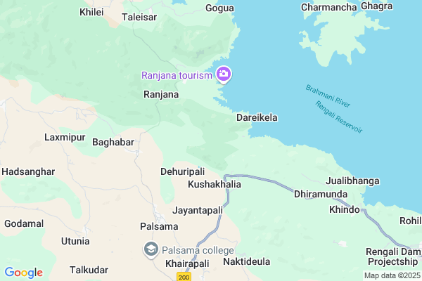
Dalbeheramunda Map
EDIT Map
Add Your House
 ..
..
Current Corona Virus Infected Patients Count in Deogarh District
| City Name | District Name | Total Covid cases |
|---|
Locality Name :
Dalbeheramunda
( ଦଳବେହେରାମୁଣ୍ଡା )
Tehsil Name : Reamal
District : Deogarh
State : Odisha
Language : Oriya and Hindi
Current Time 03:28 PM
Date: Wednesday , Apr 30,2025 (IST)
Time zone: IST (UTC+5:30)
Elevation / Altitude: 197 meters. Above Seal level
Telephone Code / Std Code: 06647
Assembly constituency : Deogarh assembly constituency
Assembly MLA : nitesh gangadeb
Lok Sabha constituency : Sambalpur parliamentary constituency
Parliament MP : NITESH GANGA DEB
Serpanch Name :
Pin Code : 768109
Post Office Name : Reamal
Commodities Prices : Talcher Market / Mandi
Dalbeheramunda Live Weather
Temperature: 38.4 °C
clear sky
Humidity: 23%
Wind : 6.12 mt/sec towards SE
StationName : "Deogarh"
observed on Now
Temperature: 38.4 °C
clear sky
Humidity: 23%
Wind : 6.12 mt/sec towards SE
StationName : "Deogarh"
observed on Now
Dalbeheramunda Weather Forecast for Next 5 days
01-05-2025
24.6°C to 34.6°C
light rain, few clouds, scattered clouds
24.6°C to 34.6°C
light rain, few clouds, scattered clouds
02-05-2025
21.7°C to 39.5°C
few clouds, clear sky, light rain, scattered clouds
21.7°C to 39.5°C
few clouds, clear sky, light rain, scattered clouds
03-05-2025
21.6°C to 38.9°C
few clouds, clear sky, scattered clouds, heavy intensity rain
21.6°C to 38.9°C
few clouds, clear sky, scattered clouds, heavy intensity rain
04-05-2025
24.7°C to 37.6°C
clear sky, few clouds, moderate rain, broken clouds, overcast clouds
24.7°C to 37.6°C
clear sky, few clouds, moderate rain, broken clouds, overcast clouds
05-05-2025
24.3°C to 41.1°C
broken clouds, few clouds, clear sky, light rain
24.3°C to 41.1°C
broken clouds, few clouds, clear sky, light rain
National Highways Reachable To Dalbeheramunda
Nationa High Way :NH53
Nationa High Way :NH53
Rivers Near Dalbeheramunda
Brahmani :Brahmani :Брагмані
Mankarha
Brahmani :Brahmani :Брагмані
Mankarha
About Dalbeheramunda
Correct below Info and add more info about DalbeheramundaDalbeheramunda is a small Village/hamlet in Reamal Tehsil in Deogarh District of Odisha State, India. It is located 37 KM towards South from District head quarters Debagarh. 24 KM from Reamal. 177 KM from State capital Bhubaneswar
Dalbeheramunda Pin code is 768109 and postal head office is Reamal .
Utunia ( 9 KM ) , Karlaga ( 10 KM ) , Khilei ( 10 KM ) , Kantabahal ( 13 KM ) , Para ( 16 KM ) are the nearby Villages to Dalbeheramunda. Dalbeheramunda is surrounded by Barkote Tehsil towards North , Kaniha Tehsil towards South , Palalahada Tehsil towards East , Deogarh Tehsil towards North .
Debagarh , Talcher , Anugul , Kuchinda are the near by Cities to Dalbeheramunda.
This Place is in the border of the Deogarh District and Sambalpur District. Sambalpur District Naktideul is west towards this place .
Dalbeheramunda 2011 Census Details
Dalbeheramunda Local Language is Oriya. Dalbeheramunda Village Total population is 244 and number of houses are 50. Female Population is 51.2%. Village literacy rate is 69.7% and the Female Literacy rate is 33.6%.
Population
| Census Parameter | Census Data |
| Total Population | 244 |
| Total No of Houses | 50 |
| Female Population % | 51.2 % ( 125) |
| Total Literacy rate % | 69.7 % ( 170) |
| Female Literacy rate | 33.6 % ( 82) |
| Scheduled Tribes Population % | 46.7 % ( 114) |
| Scheduled Caste Population % | 4.9 % ( 12) |
| Working Population % | 75.4 % |
| Child(0 -6) Population by 2011 | 23 |
| Girl Child(0 -6) Population % by 2011 | 60.9 % ( 14) |
Dalbeheramunda Census More Deatils.
Politics in Dalbeheramunda
BJP , BJD , INC are the major political parties in this area.Polling Stations /Booths near Dalbeheramunda
1)Dasgharia U.g.u.p. School2)Kureinbahal Pry. School
3)Ranigola Pry. School
4)Badmanpur Pry. School
5)Palkudar Ug.up School
HOW TO REACH Dalbeheramunda
By Rail
There is no railway station near to Dalbeheramunda in less than 10 km.Colleges near Dalbeheramunda
Palsama Science College
Address : Palsama, Deogarh
Ps +3 Degree College
Address : Budhapal, Deogarh
Schools in Dalbeheramunda
Ghodapoka P.s.
Address : dalbeheramunda , reamal , deogarh , Sikkim . PIN- 768109 , Post - Reamal
Govt Health Centers near Dalbeheramunda
1) KHAJURIA KATA , KHAJURIAKATA CHC , KHAJURIAKATA , NEAR STATE BANK OF INDIA2) Khajurikata (Main) SC , KHAJURIAKATA , KHAJURIAKATA , KHAJURIAKATA CHC
3) Hatibari , , ,
Super Markets in Dalbeheramunda,Reamal
Governement Offices near Dalbeheramunda,Reamal
About Dalbeheramunda &
History
How to reach Dalbeheramunda
Tourist Places Near By Dalbeheramunda
Schools in Dalbeheramunda
Colleges in Dalbeheramunda
Temperature & weather of Dalbeheramunda
places in Dalbeheramunda
Dalbeheramunda photos
More Information
How to reach Dalbeheramunda
Tourist Places Near By Dalbeheramunda
Schools in Dalbeheramunda
Colleges in Dalbeheramunda
Temperature & weather of Dalbeheramunda
places in Dalbeheramunda
Dalbeheramunda photos
More Information
Village Talk
Post News or Events about this Village
Near Cities
Debagarh 33 KM near
Talcher 57 KM near
Anugul 64 KM near
Kuchinda 83 KM near
Debagarh 33 KM near
Talcher 57 KM near
Anugul 64 KM near
Kuchinda 83 KM near
Near By Taluks
Reamal 22 KM near
Barkote 27 KM near
Kaniha 31 KM near
Palalahada 33 KM near
Reamal 22 KM near
Barkote 27 KM near
Kaniha 31 KM near
Palalahada 33 KM near
Near By Air Ports
Bhubaneswar Airport 169 KM near
Ranchi Airport 253 KM near
Raipur Airport 368 KM near
Gaya Airport 426 KM near
Bhubaneswar Airport 169 KM near
Ranchi Airport 253 KM near
Raipur Airport 368 KM near
Gaya Airport 426 KM near
Near By Tourist Places
Sambalpur 109 KM near
Rourkela 115 KM near
Hirakud 120 KM near
Phulbani 131 KM near
Cuttack 155 KM near
Sambalpur 109 KM near
Rourkela 115 KM near
Hirakud 120 KM near
Phulbani 131 KM near
Cuttack 155 KM near
Near By Districts
Deogarh 35 KM near
Anugul 62 KM near
Kendujhar 89 KM near
Boudh 91 KM near
Deogarh 35 KM near
Anugul 62 KM near
Kendujhar 89 KM near
Boudh 91 KM near
Near By RailWay Station
Boinda Rail Way Station 53 KM near
Talcher Rail Way Station 59 KM near
Boinda Rail Way Station 53 KM near
Talcher Rail Way Station 59 KM near