| Home | City Bus | Maps | Villages | Cities | Rail | Tourist Places | School | College | Pin Codes | Corona Cases Count |
| Distance Calculator Bus Services IFSC Codes Trace Mobile Number Weather Search Place Trace IP Available Cash ATM/Banks Locate Polling Booth Report an Error contact People |
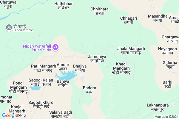
Bhajiya
Bhajiya Map
EDIT Map
Add Your House
 ..
..
Current Corona Virus Infected Patients Count in Damoh District
| City Name | District Name | Total Covid cases |
|---|
Locality Name :
Bhajiya
( भजिया )
Tehsil Name : Jabera
District : Damoh
State : Madhya Pradesh
Division : Sagar
Language : Hindi and Urdu
Current Time 12:13 AM
Date: Wednesday , Apr 30,2025 (IST)
Time zone: IST (UTC+5:30)
Elevation / Altitude: 332 meters. Above Seal level
Telephone Code / Std Code: 07606
Assembly constituency : Jabera assembly constituency
Assembly MLA : Dharmendra Bhav Singh Lodhi
Lok Sabha constituency : Damoh parliamentary constituency
Parliament MP : PRAHALAD SINGH PATEL
Serpanch Name :
Pin Code : 470881
Post Office Name : Jabera
Commodities Prices : Sihora Market / Mandi
Bhajiya Live Weather
Temperature: 31.1 °C
broken clouds
Humidity: 25%
Wind : 5.24 mt/sec towards SE
StationName : "Majholi"
observed on 38 Mins Back
Temperature: 31.1 °C
broken clouds
Humidity: 25%
Wind : 5.24 mt/sec towards SE
StationName : "Majholi"
observed on 38 Mins Back
Bhajiya Weather Forecast for Next 5 days
30-04-2025
27.1°C to 29.2°C
broken clouds
27.1°C to 29.2°C
broken clouds
01-05-2025
24.9°C to 39.5°C
scattered clouds, clear sky
24.9°C to 39.5°C
scattered clouds, clear sky
02-05-2025
26.7°C to 40.7°C
clear sky, scattered clouds
26.7°C to 40.7°C
clear sky, scattered clouds
03-05-2025
26.7°C to 42.0°C
clear sky, few clouds, broken clouds, overcast clouds, scattered clouds
26.7°C to 42.0°C
clear sky, few clouds, broken clouds, overcast clouds, scattered clouds
04-05-2025
27.4°C to 41.4°C
scattered clouds, clear sky, few clouds, broken clouds
27.4°C to 41.4°C
scattered clouds, clear sky, few clouds, broken clouds
National Highways Reachable To Bhajiya
Nationa High Way :NH30
Nationa High Way :NH30
Rivers Near Bhajiya
Hiran
Kopra Nadi
Hiran
Kopra Nadi
About Bhajiya
Correct below Info and add more info about BhajiyaBhajiya is a Village in Jabera Tehsil in Damoh District of Madhya Pradesh State, India. It belongs to Sagar Division . It is located 57 KM towards East from District head quarters Damoh. 21 KM from Jabera. 298 KM from State capital Bhopal
Bhajiya Pin code is 470881 and postal head office is Jabera .
Salaiyabadi ( 7 KM ) , Sunwarah ( 8 KM ) , Patnakuwa ( 9 KM ) , Sunkad ( 11 KM ) , Kusmimangarh ( 15 KM ) are the nearby Villages to Bhajiya. Bhajiya is surrounded by Bahoriband Tehsil towards East , Majhouli Tehsil towards South , Rithi Tehsil towards East , Sihora Tehsil towards South .
Sihora , Panagar , Damoh , Umaria are the near by Cities to Bhajiya.
Bhajiya 2011 Census Details
Bhajiya Local Language is Hindi. Bhajiya Village Total population is 1937 and number of houses are 421. Female Population is 48.7%. Village literacy rate is 55.5% and the Female Literacy rate is 22.0%.
Population
| Census Parameter | Census Data |
| Total Population | 1937 |
| Total No of Houses | 421 |
| Female Population % | 48.7 % ( 944) |
| Total Literacy rate % | 55.5 % ( 1076) |
| Female Literacy rate | 22.0 % ( 426) |
| Scheduled Tribes Population % | 19.4 % ( 375) |
| Scheduled Caste Population % | 25.9 % ( 501) |
| Working Population % | 47.8 % |
| Child(0 -6) Population by 2011 | 303 |
| Girl Child(0 -6) Population % by 2011 | 50.2 % ( 152) |
Bhajiya Census More Deatils.
Politics in Bhajiya
Bharatiya Janata Party , BJP , INC are the major political parties in this area.Polling Stations /Booths near Bhajiya
1)Bhaisakhar2)Pipariya Sunar
3)Mahuaghat
4)Haradu Singouragadh
5)Patalouni
HOW TO REACH Bhajiya
By Rail
There is no railway station near to Bhajiya in less than 10 km.Colleges near Bhajiya
Ojaswini Women Management & Engineering College
Address : Gram- Pathariya, Jat Devri Road, Sagar
Ojaswini Institute Par Excellence Damoh Mp
Address : Malaiya Mal Parisar Damoh Mp
J. L. Verma Law College
Address : J. L. Verma Law Collegedamohdistrict- Damohmadhya
Schools in Bhajiya
Middle School Bhajiya
Address : bhajiya , jabera , damoh , Madhya Pradesh . PIN- 470881 , Post - Jabera
Govt Health Centers near Bhajiya
1) SHC Podi Mangarh , SHC Podi Mangarh , Podi mangarh , Nearest Bati School PMS.2) SHC Masandha , SHC Masandha , Gram Masandha ,
3) SHC Kodakala , SHC Kodakala , Kodakala , NEAREST School M.S.& PMS.
Electronic Shops in Bhajiya,Jabera
Super Markets in Bhajiya,Jabera
Local Parks in Bhajiya,Jabera
Police Stations near Bhajiya,Jabera
Governement Offices near Bhajiya,Jabera
About Bhajiya &
History
How to reach Bhajiya
Tourist Places Near By Bhajiya
Schools in Bhajiya
Colleges in Bhajiya
Temperature & weather of Bhajiya
places in Bhajiya
Bhajiya photos
More Information
How to reach Bhajiya
Tourist Places Near By Bhajiya
Schools in Bhajiya
Colleges in Bhajiya
Temperature & weather of Bhajiya
places in Bhajiya
Bhajiya photos
More Information
Village Talk
Post News or Events about this Village
Near Cities
Sihora 34 KM near
Panagar 48 KM near
Damoh 54 KM near
Umaria 57 KM near
Sihora 34 KM near
Panagar 48 KM near
Damoh 54 KM near
Umaria 57 KM near
Near By Taluks
Jabera 20 KM near
Bahoriband 22 KM near
Majhouli 26 KM near
Rithi 41 KM near
Jabera 20 KM near
Bahoriband 22 KM near
Majhouli 26 KM near
Rithi 41 KM near
Near By Air Ports
Jabalpur Airport 123 KM near
Khajuraho Airport 144 KM near
Bhopal Airport 293 KM near
Bamrauli Airport 305 KM near
Jabalpur Airport 123 KM near
Khajuraho Airport 144 KM near
Bhopal Airport 293 KM near
Bamrauli Airport 305 KM near
Near By Tourist Places
Bandhavgarh National Park 58 KM near
Jabalpur 62 KM near
Bhedaghat 67 KM near
Maihar 124 KM near
Panna 136 KM near
Bandhavgarh National Park 58 KM near
Jabalpur 62 KM near
Bhedaghat 67 KM near
Maihar 124 KM near
Panna 136 KM near
Near By Districts
Damoh 54 KM near
Katni 62 KM near
Jabalpur 63 KM near
Umaria 111 KM near
Damoh 54 KM near
Katni 62 KM near
Jabalpur 63 KM near
Umaria 111 KM near
Near By RailWay Station
Sihora Road Rail Way Station 35 KM near
Bandakpur Rail Way Station 41 KM near
Sihora Road Rail Way Station 35 KM near
Bandakpur Rail Way Station 41 KM near