| Home | City Bus | Maps | Villages | Cities | Rail | Tourist Places | School | College | Pin Codes | Corona Cases Count |
| Distance Calculator Bus Services IFSC Codes Trace Mobile Number Weather Search Place Trace IP Available Cash ATM/Banks Locate Polling Booth Report an Error contact People |
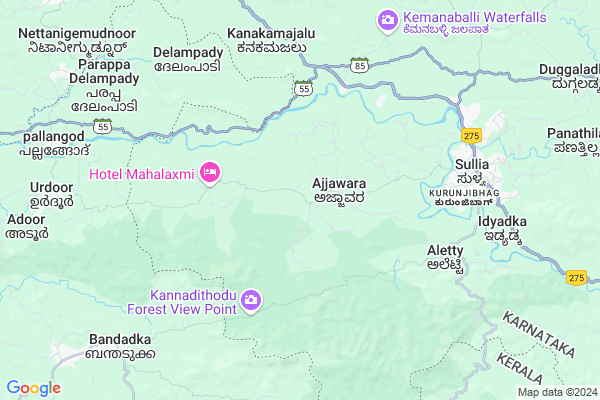
Iranthamajalu
Iranthamajalu Map
EDIT Map
Add Your House
 ..
..
Current Corona Virus Infected Patients Count in Dakshin Kannad District
| City Name | District Name | Total Covid cases |
|---|---|---|
| Dakshina Kannada District | Dakshina Kannada | 7 |
| Bantwala | Dakshina Kannada | 2 |
| Uppinangadi | Dakshina Kannada | 2 |
| Bantwal | Dakshina Kannada | 1 |
| Panemangalore | Dakshina Kannada | 1 |
Locality Name :
Iranthamajalu
( ಇರಂತಮಜಲು )
Taluk Name : Sulya
District : Dakshin Kannad
State : Karnataka
Division : Mysore
Language : Tulu and Kannada, Konkani, Beary Bashe.
Current Time 01:47 PM
Date: Tuesday , Apr 29,2025 (IST)
Time zone: IST (UTC+5:30)
Elevation / Altitude: 82 meters. Above Seal level
Telephone Code / Std Code: 08257
Assembly constituency : Sullia assembly constituency
Assembly MLA : Bhagirathi Murulya
Lok Sabha constituency : Dakshina Kannada parliamentary constituency
Parliament MP : NALIN KUMAR KATEEL
Serpanch Name :
Pin Code : 574239
Post Office Name : Sullia
Main Village Name : Ajjavara
Commodities Prices : Sulya Market / Mandi
National Highways Reachable To Iranthamajalu
Nationa High Way :NH66
Nationa High Way :NH275
Nationa High Way :NH66
Nationa High Way :NH275
Rivers Near Iranthamajalu
Uppala :ಉಪ್ಪಳ :ഉപ്പള
munchikana thodu
Uppala :ಉಪ್ಪಳ :ഉപ്പള
munchikana thodu
About Iranthamajalu
Correct below Info and add more info about IranthamajaluIranthamajalu is a small Village/hamlet in Sulya Taluk in Dakshin Kannad District of Karnataka State, India. It comes under Ajjavara Panchayath. It belongs to Mysore Division . It is located 76 KM towards East from District head quarters Mangalore. 14 KM from Sulya. 292 KM from State capital Bangalore
Iranthamajalu Pin code is 574239 and postal head office is Sullia .
Iranthamajalu is surrounded by Puttur Taluk towards North , Kanhangad Taluk towards west , Kasargod Taluk towards west , Nileshwar Taluk towards South .
Puttur , Kanhangad , Kasaragod , Madikeri are the near by Cities to Iranthamajalu.
Demographics of Iranthamajalu
Tulu is the Local Language here. Total population of Iranthamajalu is 6692 .Males are 3406 and Females are 3,286 living in 1251 Houses. Total area of Iranthamajalu is 2452 hectares.Politics in Iranthamajalu
Bharatiya Janata Party , BJP , Bharatiya Janata Party (BJP) , INC are the major political parties in this area.Polling Stations /Booths near Iranthamajalu
1)Da. Ka. Zilla Panchayath Lower Primary School. Bolubailu2)N.r. Gowda M.h.p.s. Kanakamajalu (east Wing)
3)Malnadu Mahathmagandhi High School Kodiyalabailu.
4)Da. Ka. Zilla Panchayath Higher Primary School. Guthigaru Mogra(east Wing)
5)Da. Ka. Zilla Panchayath Upgrade Higher Primary School Kanthamangila
HOW TO REACH Iranthamajalu
By Road
Sulya is the Nearest Town to Iranthamajalu. Sulya is 8 km from Iranthamajalu. Road connectivity is there from Sulya to Iranthamajalu.By Rail
There is no railway station near to Iranthamajalu in less than 10 km.Colleges near Iranthamajalu
Mangalore Marine College
Address :
Vijaya College Mulki
Address :
Govt Junior Collage
Address :
Goverment Pu College Koyyur
Address :
Govt. Primary School Kanchinadka
Address :
Schools in Iranthamajalu
Gups, Kanthamangala
Address : ajjavara , sullia , dakshina kannada , Karnataka . PIN- 574239 , Post - Sullia
Gups, Adpangaya
Address : ajjavara , sullia , dakshina kannada , Karnataka . PIN- 574239 , Post - Sullia
Gups, Mulya Atluru
Address : ajjavara , sullia , dakshina kannada , Karnataka . PIN- 574239 , Post - Sullia
Gups, Ajjavara
Address : ajjavara , sullia , dakshina kannada , Karnataka . PIN- 574239 , Post - Sullia
Govt Health Centers near Iranthamajalu
1) Kadaba , Primary Health Centre Kadaba , , CHC COMPOUND2) UPPINANGADI 24X7 , Primary Health Centre Uppinangady , , NEAR UPPINANGADY BUS STAND
3) UPPINANGADI 24X7 , , ,
Petrol Bunks in Iranthamajalu,Sulya
KVG High Tension Power House for Medical Section
Kurunjibhag; Sullia; Karnataka 574327; India
6.8 KM distance Detail
more ..
Colleges in Iranthamajalu,Sulya
KVG Industrial Traning Institute
Kurunjibhag; Sullia; Karnataka 574327; India
6.6 KM distance Detail
more ..
Schools in Iranthamajalu,Sulya
G H S Ajjavara
G H; Balakrisha Naik;Ajjavara; Adoor - Sulya Rd; Ajjavara; Karnataka 574239; India
1.2 KM distance Detail
Govt Higher Primary School Ajjavara
Adoor - Sulya Rd; Ajjavara; Karnataka 574239; India
1.3 KM distance Detail
About Iranthamajalu &
History
How to reach Iranthamajalu
Tourist Places Near By Iranthamajalu
Schools in Iranthamajalu
Colleges in Iranthamajalu
Temperature & weather of Iranthamajalu
places in Iranthamajalu
Iranthamajalu photos
More Information
How to reach Iranthamajalu
Tourist Places Near By Iranthamajalu
Schools in Iranthamajalu
Colleges in Iranthamajalu
Temperature & weather of Iranthamajalu
places in Iranthamajalu
Iranthamajalu photos
More Information
Village Talk
Post News or Events about this Village
Near Cities
Puttur 31 KM near
Kanhangad 41 KM near
Kasaragod 41 KM near
Madikeri 53 KM near
Puttur 31 KM near
Kanhangad 41 KM near
Kasaragod 41 KM near
Madikeri 53 KM near
Near By Taluks
Sulya 14 KM near
Puttur 26 KM near
Kanhangad 31 KM near
Kasargod 35 KM near
Sulya 14 KM near
Puttur 26 KM near
Kanhangad 31 KM near
Kasargod 35 KM near
Near By Air Ports
Bajpe Airport 74 KM near
Mysore Airport 163 KM near
Calicut Airport 191 KM near
Peelamedu Airport 281 KM near
Bajpe Airport 74 KM near
Mysore Airport 163 KM near
Calicut Airport 191 KM near
Peelamedu Airport 281 KM near
Near By Tourist Places
Kukke Subramanya 37 KM near
Talacauvery 37 KM near
Kasargod 40 KM near
Bekal 40 KM near
Dharamsthala 50 KM near
Kukke Subramanya 37 KM near
Talacauvery 37 KM near
Kasargod 40 KM near
Bekal 40 KM near
Dharamsthala 50 KM near
Near By Districts
Kasaragod 41 KM near
Kodagu 52 KM near
Dakshin Kannad 73 KM near
Kannur 84 KM near
Kasaragod 41 KM near
Kodagu 52 KM near
Dakshin Kannad 73 KM near
Kannur 84 KM near
Near By RailWay Station
Kabakaputtur Rail Way Station 31 KM near
Subrahmanya Road Rail Way Station 35 KM near
Kabakaputtur Rail Way Station 31 KM near
Subrahmanya Road Rail Way Station 35 KM near