| Home | City Bus | Maps | Villages | Cities | Rail | Tourist Places | School | College | Pin Codes | Corona Cases Count |
| Distance Calculator Bus Services IFSC Codes Trace Mobile Number Weather Search Place Trace IP Available Cash ATM/Banks Locate Polling Booth Report an Error contact People |
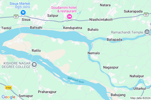
Arei
Arei Map
EDIT Map
Add Your House
 ..
..
Current Corona Virus Infected Patients Count in Cuttack District
| City Name | District Name | Total Covid cases |
|---|---|---|
| Cuttack District | Cuttack | 1 |
Locality Name :
Arei
( ଏରେଇଁ )
Tehsil Name : Nischinta Koili
District : Cuttack
State : Odisha
Language : Oriya and Hindi
Current Time 01:10 PM
Date: Wednesday , Feb 05,2025 (IST)
Time zone: IST (UTC+5:30)
Elevation / Altitude: 14 meters. Above Seal level
Telephone Code / Std Code: 06725
Assembly constituency : Cuttack Sadar assembly constituency
Assembly MLA : chandra sarathi behera
Lok Sabha constituency : Cuttack parliamentary constituency
Parliament MP : BHARTRUHARI MAHTAB
Serpanch Name :
Pin Code : 754131
Post Office Name : Kishorenagar
Commodities Prices : Kendupatna Market / Mandi
Arei Live Weather
Temperature: 31.6 °C
overcast clouds
Humidity: 43%
Wind : 2.16 mt/sec towards W
StationName : "Jagatsinghapur"
observed on 1 Hours Back
Temperature: 31.6 °C
overcast clouds
Humidity: 43%
Wind : 2.16 mt/sec towards W
StationName : "Jagatsinghapur"
observed on 1 Hours Back
Arei Weather Forecast for Next 5 days
06-02-2025
23.2°C to 34.5°C
overcast clouds, broken clouds, clear sky, scattered clouds
23.2°C to 34.5°C
overcast clouds, broken clouds, clear sky, scattered clouds
07-02-2025
22.5°C to 34.3°C
overcast clouds, broken clouds, scattered clouds, few clouds, clear sky
22.5°C to 34.3°C
overcast clouds, broken clouds, scattered clouds, few clouds, clear sky
08-02-2025
21.4°C to 32.1°C
clear sky, light rain, few clouds
21.4°C to 32.1°C
clear sky, light rain, few clouds
09-02-2025
20.7°C to 32.5°C
clear sky
20.7°C to 32.5°C
clear sky
10-02-2025
21.0°C to 34.0°C
clear sky, few clouds
21.0°C to 34.0°C
clear sky, few clouds
National Highways Reachable To Arei
Nationa High Way :NH53
Nationa High Way :NH55
Nationa High Way :NH53
Nationa High Way :NH55
Rivers Near Arei
Brahmani :Брагмані
Rana
Brahmani :Брагмані
Rana
About Arei
Correct below Info and add more info about AreiArei is a small Village/hamlet in Nischinta Koili Tehsil in Cuttack District of Odisha State, India. It is located 32 KM towards East from District head quarters Cuttack. 5 KM from Nischintakoili. 43 KM from State capital Bhubaneswar
Arei Pin code is 754131 and postal head office is Kishorenagar .
Santapur ( 3 KM ) , Nuagaon ( 3 KM ) , Purunahat ( 4 KM ) , Tilakana ( 4 KM ) , Buhalo ( 4 KM ) are the nearby Villages to Arei. Arei is surrounded by Salepur Tehsil towards west , Raghunathpur Tehsil towards South , Biridi Tehsil towards South , Mahanga Tehsil towards North .
Jagatsinghapur , Cuttack , Kendrapara , Bhubaneswar are the near by Cities to Arei.
This Place is in the border of the Cuttack District and Kendrapara District. Kendrapara District Derabish is East towards this place . Also it is in the Border of other district Jagatsinghapur .
Arei 2011 Census Details
Arei Local Language is Oriya. Arei Village Total population is 771 and number of houses are 187. Female Population is 46.0%. Village literacy rate is 82.0% and the Female Literacy rate is 36.1%.
Population
| Census Parameter | Census Data |
| Total Population | 771 |
| Total No of Houses | 187 |
| Female Population % | 46.0 % ( 355) |
| Total Literacy rate % | 82.0 % ( 632) |
| Female Literacy rate | 36.1 % ( 278) |
| Scheduled Tribes Population % | 0.0 % ( 0) |
| Scheduled Caste Population % | 34.5 % ( 266) |
| Working Population % | 39.2 % |
| Child(0 -6) Population by 2011 | 85 |
| Girl Child(0 -6) Population % by 2011 | 32.9 % ( 28) |
Arei Census More Deatils.
Politics in Arei
BJP , BJD , are the major political parties in this area.Polling Stations /Booths near Arei
1)Raghunathapur Pry. School2)Raghunathjew Bidya Pitha Bandhupur
3)Kajipatana U.p. School
4)Berhampur Pry. School
5)Manijanga Pry. School
HOW TO REACH Arei
By Rail
Raghunathpur Rail Way Station is the very nearby railway stations to Arei.Colleges near Arei
Panchayat Prahallad College
Address :
Schools in Arei
Arei Ps
Address : arei , nischintakoili , cuttack , Sikkim . PIN- 754131 , Post - Kishorenagar
Govt Health Centers near Arei
1) NAGASPUR , , , Nagaspur Chhak2) ORTI , , , Orti PHC (New)
3) Gardapur PHC(N) , , Patkura , Near Patkura Block Office
Hospitals in Arei,Nischinta Koili
Santapur PHC; Medical Centre
At-santapur;po-orikanta;Near saraswati sisu mandir; Bhabarchand Rd; Orikanta; Odisha 754293; India
2.7 KM distance Detail
Government Hospital
Nischintakoili; Cuttack; SH-9A; Aul Kendrapada Jagatpur Road; Salepur; Salipur; Odisha 754207; India
5.7 KM distance Detail
more ..
Petrol Bunks in Arei,Nischinta Koili
Vishwanath Fuel Station Petrol Pump
Nischintakoili; Cuttack; SH-9A; Aul Kendrapada Jagatpur Road; Salepur; Salepur; Odisha 754207; India
8.8 KM distance Detail
more ..
Colleges in Arei,Nischinta Koili
NABAPRAVAT ACADEMY FOR MANAGEMENT EDUCATION
Sunakhandi(Educational Area);Close to Kasipur; Primary School; Salipur; Odisha 754202; India
6.4 KM distance Detail
more ..
Schools in Arei,Nischinta Koili
Lal Bahadur Bidya Pitha;Orikanta
Bhabarchand Rd; Orikanta; Odisha 754293; India
2.5 KM distance Detail
About Arei &
History
How to reach Arei
Tourist Places Near By Arei
Schools in Arei
Colleges in Arei
Temperature & weather of Arei
places in Arei
Arei photos
More Information
How to reach Arei
Tourist Places Near By Arei
Schools in Arei
Colleges in Arei
Temperature & weather of Arei
places in Arei
Arei photos
More Information
Village Talk
Post News or Events about this Village
Near Cities
Jagatsinghapur 21 KM near
Cuttack 31 KM near
Kendrapara 32 KM near
Bhubaneswar 43 KM near
Jagatsinghapur 21 KM near
Cuttack 31 KM near
Kendrapara 32 KM near
Bhubaneswar 43 KM near
Near By Taluks
Nischinta Koili 4 KM near
Salepur 9 KM near
Raghunathpur 14 KM near
Biridi 15 KM near
Nischinta Koili 4 KM near
Salepur 9 KM near
Raghunathpur 14 KM near
Biridi 15 KM near
Near By Air Ports
Bhubaneswar Airport 45 KM near
Ranchi Airport 370 KM near
Netaji Subhas Chandra Bose Airport 381 KM near
Vishakhapatnam Airport 482 KM near
Bhubaneswar Airport 45 KM near
Ranchi Airport 370 KM near
Netaji Subhas Chandra Bose Airport 381 KM near
Vishakhapatnam Airport 482 KM near
Near By Tourist Places
Cuttack 31 KM near
Nandan Kanan National Park 39 KM near
Bhubaneswar 42 KM near
Paradeep Beach 56 KM near
Konark 68 KM near
Cuttack 31 KM near
Nandan Kanan National Park 39 KM near
Bhubaneswar 42 KM near
Paradeep Beach 56 KM near
Konark 68 KM near
Near By Districts
Jagatsinghapur 22 KM near
Cuttack 31 KM near
Kendrapara 32 KM near
Khordha 43 KM near
Jagatsinghapur 22 KM near
Cuttack 31 KM near
Kendrapara 32 KM near
Khordha 43 KM near
Near By RailWay Station
Cuttack Junction Rail Way Station 29 KM near
Mancheswar Rail Way Station 38 KM near
Cuttack Junction Rail Way Station 29 KM near
Mancheswar Rail Way Station 38 KM near