| Home | City Bus | Maps | Villages | Cities | Rail | Tourist Places | School | College | Pin Codes | Corona Cases Count |
| Distance Calculator Bus Services IFSC Codes Trace Mobile Number Weather Search Place Trace IP Available Cash ATM/Banks Locate Polling Booth Report an Error contact People |
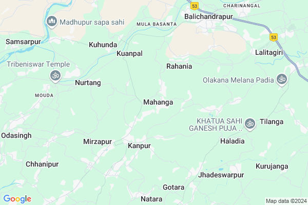
Barabati Map
EDIT Map
Add Your House
 ..
..
Current Corona Virus Infected Patients Count in Cuttack District
| City Name | District Name | Total Covid cases |
|---|---|---|
| Cuttack District | Cuttack | 1 |
Locality Name :
Barabati
( ବାରବାଟୀ )
Tehsil Name : Mahanga
District : Cuttack
State : Odisha
Language : Oriya and Hindi
Current Time 11:28 AM
Date: Monday , Apr 28,2025 (IST)
Time zone: IST (UTC+5:30)
Elevation / Altitude: 30 meters. Above Seal level
Telephone Code / Std Code: 06725
Assembly constituency : Mahanga assembly constituency
Assembly MLA : pratap jena
Lok Sabha constituency : Kendrapara parliamentary constituency
Parliament MP : Anubhav Mohanty
Serpanch Name :
Commodities Prices : Kendupatna Market / Mandi
National Highways Reachable To Barabati
Nationa High Way :NH53
Nationa High Way :NH55
Nationa High Way :NH53
Nationa High Way :NH55
Rivers Near Barabati
Brahmani :Брагмані
Rana
Brahmani :Брагмані
Rana
About Barabati
Correct below Info and add more info about BarabatiBarabati is a small Village/hamlet in Mahanga Tehsil in Cuttack District of Odisha State, India. It is located 39 KM towards East from District head quarters Cuttack. 57 KM from State capital Bhubaneswar
Barabati is surrounded by Nischinta Koili Tehsil towards South , Salepur Tehsil towards west , Badchana Tehsil towards North , Derabish Tehsil towards East .
Kendrapara , Jagatsinghapur , Cuttack , Jajapur are the near by Cities to Barabati.
This Place is in the border of the Cuttack District and Kendrapara District. Kendrapara District Derabish is East towards this place . Also it is in the Border of other district Jajapur .
Barabati 2011 Census Details
Barabati Local Language is Oriya. Barabati Village Total population is 138 and number of houses are 31. Female Population is 51.4%. Village literacy rate is 83.3% and the Female Literacy rate is 40.6%.
Population
| Census Parameter | Census Data |
| Total Population | 138 |
| Total No of Houses | 31 |
| Female Population % | 51.4 % ( 71) |
| Total Literacy rate % | 83.3 % ( 115) |
| Female Literacy rate | 40.6 % ( 56) |
| Scheduled Tribes Population % | 0.0 % ( 0) |
| Scheduled Caste Population % | 67.4 % ( 93) |
| Working Population % | 27.5 % |
| Child(0 -6) Population by 2011 | 6 |
| Girl Child(0 -6) Population % by 2011 | 16.7 % ( 1) |
Barabati Census More Deatils.
Politics in Barabati
BJD is the major political party in this area.Polling Stations /Booths near Barabati
1)Brajarajpatana Pry. School2)Pyarimani U.p. (m.e) School Patapur
3)Mahanga G.p. Office
4)Mahajanapur Pry. School
5)Mahanga Mahabir Pry. School
HOW TO REACH Barabati
By Rail
There is no railway station near to Barabati in less than 10 km.Pincodes near Barabati
754206 ( Mahanga ) , 754221 ( Sungura (Cuttack) ) , 754204 ( Kuanpal )Colleges near Barabati
Jwahar Lal Nehru College ,kuanpal ,cuttack
Address :
Mahanga Puspagiri Mahavidyalaya
Address :
Barabati Institute Of Management Studies
Address : Plot No: 242, Biswalpada,po : Khandeitavia: Gopalp
Schools in Barabati
Barabati Proj. Ps
Address : barabati , mahanga , cuttack , Sikkim . PIN- 754206 , Post - Mahanga
Govt Health Centers near Barabati
1) ORTI , , , Orti PHC (New)2) NAGASPUR , , , Nagaspur Chhak
3) Haripur SC , 38 , Balia , Nahan Nodal UP School
Hospitals in Barabati,Mahanga
Veterinary Dispensary;Mahanga
Chhatratota Mahanga Road; Budhukunia; Odisha 754206; India
0.6 KM distance Detail
Pallisahi homeopathic hospital
754221; Salepur-Mahanga Road; Pallisahi; Odisha; India
3.1 KM distance Detail
more ..
Schools in Barabati,Mahanga
BINOD BIHARI BIDYAMANDIR
Salepur-Mahanga Road; Raghunathnagar; Odisha 754206; India
1.3 KM distance Detail
Super Markets in Barabati,Mahanga
Shree Jagannath Traders
Salepur-Mahanga Road; Kusundaspur; Odisha 754206; India
1.0 KM distance Detail
Police Stations near Barabati,Mahanga
Erakana square
Mahanga-Katikata road;Erakana Bazar; Goratanga; Odisha 754206; India
5.4 KM distance Detail
About Barabati &
History
How to reach Barabati
Tourist Places Near By Barabati
Schools in Barabati
Colleges in Barabati
Temperature & weather of Barabati
places in Barabati
Barabati photos
More Information
How to reach Barabati
Tourist Places Near By Barabati
Schools in Barabati
Colleges in Barabati
Temperature & weather of Barabati
places in Barabati
Barabati photos
More Information
Village Talk
Post News or Events about this Village
Near Cities
Kendrapara 27 KM near
Jagatsinghapur 36 KM near
Cuttack 38 KM near
Jajapur 39 KM near
Kendrapara 27 KM near
Jagatsinghapur 36 KM near
Cuttack 38 KM near
Jajapur 39 KM near
Near By Taluks
Mahanga 0 KM near
Nischinta Koili 14 KM near
Salepur 14 KM near
Badchana 15 KM near
Mahanga 0 KM near
Nischinta Koili 14 KM near
Salepur 14 KM near
Badchana 15 KM near
Near By Air Ports
Bhubaneswar Airport 57 KM near
Ranchi Airport 357 KM near
Netaji Subhas Chandra Bose Airport 367 KM near
Vishakhapatnam Airport 495 KM near
Bhubaneswar Airport 57 KM near
Ranchi Airport 357 KM near
Netaji Subhas Chandra Bose Airport 367 KM near
Vishakhapatnam Airport 495 KM near
Near By Tourist Places
Cuttack 38 KM near
Nandan Kanan National Park 48 KM near
Bhubaneswar 53 KM near
Paradeep Beach 58 KM near
Konark 83 KM near
Cuttack 38 KM near
Nandan Kanan National Park 48 KM near
Bhubaneswar 53 KM near
Paradeep Beach 58 KM near
Konark 83 KM near
Near By Districts
Kendrapara 27 KM near
Jagatsinghapur 37 KM near
Cuttack 37 KM near
Jajapur 40 KM near
Kendrapara 27 KM near
Jagatsinghapur 37 KM near
Cuttack 37 KM near
Jajapur 40 KM near
Near By RailWay Station
Cuttack Junction Rail Way Station 35 KM near
Jajpur Keonjhar Road Rail Way Station 48 KM near
Cuttack Junction Rail Way Station 35 KM near
Jajpur Keonjhar Road Rail Way Station 48 KM near