| Home | City Bus | Maps | Villages | Cities | Rail | Tourist Places | School | College | Pin Codes | Corona Cases Count |
| Distance Calculator Bus Services IFSC Codes Trace Mobile Number Weather Search Place Trace IP Available Cash ATM/Banks Locate Polling Booth Report an Error contact People |
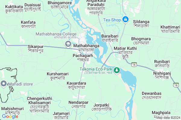
Kedarhat
Kedarhat Map
EDIT Map
Add Your House
 ..
..
Current Corona Virus Infected Patients Count in Coochbehar District
| City Name | District Name | Total Covid cases |
|---|
Locality Name :
Kedarhat
( কেদারহাট )
Block Name : Mathabhanga-i
District : Coochbehar
State : West Bengal
Division : Jalpaiguri
Language : Bengali and Hindi
Current Time 09:34 AM
Date: Sunday , Apr 27,2025 (IST)
Time zone: IST (UTC+5:30)
Elevation / Altitude: 58 meters. Above Seal level
Telephone Code / Std Code: 03584
Assembly constituency : Mathabhanga assembly constituency
Assembly MLA : Sushil Barman
Lok Sabha constituency : Cooch Behar parliamentary constituency
Parliament MP : NISITH PRAMANIK
Serpanch Name :
Pin Code : 736157
Post Office Name : Nishiganj
Commodities Prices : Mathabhanga Market / Mandi
Kedarhat Live Weather
Temperature: 25.7 °C
overcast clouds
Humidity: 70%
Wind : 4.01 mt/sec towards E
StationName : "MÄ\u0081tÄ\u0081bhÄ\u0081nga"
observed on 2 Hours Back
Temperature: 25.7 °C
overcast clouds
Humidity: 70%
Wind : 4.01 mt/sec towards E
StationName : "MÄ\u0081tÄ\u0081bhÄ\u0081nga"
observed on 2 Hours Back
Kedarhat Weather Forecast for Next 5 days
28-04-2025
21.3°C to 35.7°C
light rain, broken clouds, overcast clouds, moderate rain, heavy intensity rain
21.3°C to 35.7°C
light rain, broken clouds, overcast clouds, moderate rain, heavy intensity rain
29-04-2025
21.5°C to 32.4°C
broken clouds, overcast clouds, light rain
21.5°C to 32.4°C
broken clouds, overcast clouds, light rain
30-04-2025
21.8°C to 29.8°C
overcast clouds, light rain
21.8°C to 29.8°C
overcast clouds, light rain
01-05-2025
21.6°C to 25.2°C
light rain, overcast clouds, broken clouds
21.6°C to 25.2°C
light rain, overcast clouds, broken clouds
02-05-2025
21.7°C to 31.7°C
overcast clouds, broken clouds, scattered clouds, light rain
21.7°C to 31.7°C
overcast clouds, broken clouds, scattered clouds, light rain
National Highways Reachable To Kedarhat
Nationa High Way :NH27
Nationa High Way :NH27
Rivers Near Kedarhat
Karala River
Jaldhaka
Karala River
Jaldhaka
About Kedarhat
Correct below Info and add more info about KedarhatKedarhat is a Village in Mathabhanga-i Block in Coochbehar District of West Bengal State, India. It belongs to Jalpaiguri Division . It is located 28 KM towards west from District head quarters Cooch Behar. 499 KM from State capital Kolkata
Kedarhat Pin code is 736157 and postal head office is Nishiganj .
Kedarhat is surrounded by Matha Bhanga-Ii Block towards East , Sitalkuchi Block towards South , Falakata Block towards North , Cooch Behar-I Block towards East .
Mathabhanga , Cooch Behar , Alipurduar , Mainaguri are the near by Cities to Kedarhat.
Demographics of Kedarhat
Bengali is the Local Language here.Politics in Kedarhat
CPM , CPI(M) , AITC , BJP , INC are the major political parties in this area.Polling Stations /Booths near Kedarhat
1)Dwarikamari Fourth Plan Primary School2)Fakirer Kuthi Fourth Plan Primary School
3)Mathabhanga Harijan Basti Government Sponsored Free Refuge Rehabilitation Primary School
4)Mathabhanga Madhyamik Balika Vidyalaya
5)Bherbheri Manabari Fifth Plan Primary School
HOW TO REACH Kedarhat
By Rail
There is no railway station near to Kedarhat in less than 10 km.Colleges near Kedarhat
Pimt College
Address :
Pinacle Institute Of Managemant & Technology( Pimt)
Address :
Schools near Kedarhat
M.bhanga M. Balika V.pith
Address : word - 9 , mathabhanga municipality , koch bihar , West Bengal . PIN- 736146 , Post - Mathabhanga
Dalanath High School
Address : gopalpur / iv , mathabhanga-i , koch bihar , West Bengal . PIN- 735303 , Post - Jamaldah
Satgram K.mari High School
Address : kurshamari / iii , mathabhanga-i , koch bihar , West Bengal . PIN- 736146 , Post - Mathabhanga
Jorpatki High School
Address : jorepatki / xiii , mathabhanga-i , koch bihar , West Bengal . PIN- 736146 , Post - Mathabhanga
Govt Health Centers near Kedarhat
1) Uttar Rangalibazna , , Dangapara, Uttar rangalibazna , Near by BotTala2) Toorsha TG , , Toorsa TG , Bebari Club Gound
3) West Falakata , West Falakata , PARANGERPAR , NEAR RAICHENGA PRIMARY SCHOOL
Hospitals in Kedarhat,Mathabhanga-i
Sarkar Barman. HARBHANGA KABIRAJ
barashimul guri.satish roy hat; Cooch Behar; West Bengal; India
14.4 KM distance Detail
Putimari Phuleswari Primary Health Centre
Chandamari; West Bengal 736157; India
18.1 KM distance Detail
more ..
Colleges in Kedarhat,Mathabhanga-i
Kabiguru Rabindranath College of Education
Sitai Road; West Bengal 736158; India
17.3 KM distance Detail
Kabiguru Rabindranath Mbs College Of Education
Cooch Behar; West Bengal 736172; India
17.3 KM distance Detail
Gitanjali Prymari Teachers Training Institute.
Cooch Behar; West Bengal 736172; India
17.4 KM distance Detail
more ..
Super Markets in Kedarhat,Mathabhanga-i
About Kedarhat &
History
How to reach Kedarhat
Tourist Places Near By Kedarhat
Schools in Kedarhat
Colleges in Kedarhat
Temperature & weather of Kedarhat
places in Kedarhat
Kedarhat photos
More Information
How to reach Kedarhat
Tourist Places Near By Kedarhat
Schools in Kedarhat
Colleges in Kedarhat
Temperature & weather of Kedarhat
places in Kedarhat
Kedarhat photos
More Information
Village Talk
Post News or Events about this Village
Near Cities
Mathabhanga 0 KM near
Cooch Behar 25 KM near
Alipurduar 39 KM near
Mainaguri 53 KM near
Mathabhanga 0 KM near
Cooch Behar 25 KM near
Alipurduar 39 KM near
Mainaguri 53 KM near
Near By Taluks
Mathabhanga-I 0 KM near
Matha Bhanga-Ii 10 KM near
Sitalkuchi 21 KM near
Falakata 23 KM near
Mathabhanga-I 0 KM near
Matha Bhanga-Ii 10 KM near
Sitalkuchi 21 KM near
Falakata 23 KM near
Near By Air Ports
Rupsi Airport 80 KM near
Bagdogra Airport 109 KM near
Borjhar Airport 266 KM near
Shillong Airport 313 KM near
Rupsi Airport 80 KM near
Bagdogra Airport 109 KM near
Borjhar Airport 266 KM near
Shillong Airport 313 KM near
Near By Tourist Places
Cooch-Behar 25 KM near
Jaldapara Wildlife Sanctuary 36 KM near
Lolegaon 43 KM near
Jaldhaka 43 KM near
Jalpaiguri 59 KM near
Cooch-Behar 25 KM near
Jaldapara Wildlife Sanctuary 36 KM near
Lolegaon 43 KM near
Jaldhaka 43 KM near
Jalpaiguri 59 KM near
Near By Districts
Coochbehar 26 KM near
Jalpaiguri 60 KM near
Dhubri 92 KM near
Kokrajhar 117 KM near
Coochbehar 26 KM near
Jalpaiguri 60 KM near
Dhubri 92 KM near
Kokrajhar 117 KM near
Near By RailWay Station
Falakata Rail Way Station 24 KM near
New Cooch Behar Rail Way Station 27 KM near
Falakata Rail Way Station 24 KM near
New Cooch Behar Rail Way Station 27 KM near