| Home | City Bus | Maps | Villages | Cities | Rail | Tourist Places | School | College | Pin Codes | Corona Cases Count |
| Distance Calculator Bus Services IFSC Codes Trace Mobile Number Weather Search Place Trace IP Available Cash ATM/Banks Locate Polling Booth Report an Error contact People |
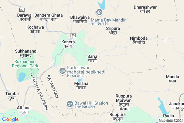
Sarsi
Sarsi Map
EDIT Map
Add Your House
 ..
..
Current Corona Virus Infected Patients Count in Chittorgarh District
| City Name | District Name | Total Covid cases |
|---|
Locality Name :
Sarsi
( सरसी )
Tehsil Name : Nimbahera
District : Chittorgarh
State : Rajasthan
Division : Udaipur
Language : Hindi and Rajasthani
Current Time 09:26 AM
Date: Thursday , Apr 24,2025 (IST)
Time zone: IST (UTC+5:30)
Elevation / Altitude: 441 meters. Above Seal level
Telephone Code / Std Code: 01477
Assembly constituency : Nimbahera assembly constituency
Assembly MLA :
Lok Sabha constituency : Chittorgarh parliamentary constituency
Parliament MP :
Serpanch Name :
Pin Code : 312606
Post Office Name : Kanera
Commodities Prices : Javad Market / Mandi
National Highways Reachable To Sarsi
Nationa High Way :NH56
Nationa High Way :NH156
Nationa High Way :NH56
Nationa High Way :NH156
Rivers Near Sarsi
Gambhiri
Wagli Nadi
Gambhiri
Wagli Nadi
About Sarsi
Correct below Info and add more info about SarsiSarsi is a Village in Nimbahera Tehsil in Chittorgarh District of Rajasthan State, India. It belongs to Udaipur Division . It is located 42 KM towards East from District head quarters Chittorgarh. 30 KM from Nimboda. 307 KM from State capital Jaipur
Sarsi Pin code is 312606 and postal head office is Kanera .
Mailana ( 3 KM ) , Bhawaliya ( 5 KM ) , Bangera Ghata ( 7 KM ) , Barawali ( 10 KM ) are the nearby Villages to Sarsi. Sarsi is surrounded by Nimbahera Tehsil towards west , Neemuch Tehsil towards South , Chittaurgarh Tehsil towards west , Begun Tehsil towards North .
Neemuch , Nimbahera , Manasa , Mandalgarh are the near by Cities to Sarsi.
This Place is in the border of the Chittorgarh District and Neemuch District. Neemuch District Jawad is South towards this place . It is near to the Madhya Pradesh State Border.
Sarsi 2011 Census Details
Sarsi Local Language is Hindi. Sarsi Village Total population is 1375 and number of houses are 303. Female Population is 48.9%. Village literacy rate is 64.1% and the Female Literacy rate is 24.6%.
Population
| Census Parameter | Census Data |
| Total Population | 1375 |
| Total No of Houses | 303 |
| Female Population % | 48.9 % ( 673) |
| Total Literacy rate % | 64.1 % ( 881) |
| Female Literacy rate | 24.6 % ( 338) |
| Scheduled Tribes Population % | 7.9 % ( 109) |
| Scheduled Caste Population % | 6.3 % ( 87) |
| Working Population % | 64.8 % |
| Child(0 -6) Population by 2011 | 154 |
| Girl Child(0 -6) Population % by 2011 | 40.3 % ( 62) |
Sarsi Census More Deatils.
Politics in Sarsi
Bharatiya Janata Party , BJP , INC are the major political parties in this area.Polling Stations /Booths near Sarsi
1)Govt. Secondry School Sajanpur2)Govt. Higher Secondry School [south Part] Lasdawan
3)Govt. Higher Secondry School Kanera (east Part)
4)Govt. Secondry School [south Part] Badoli Ghata
5)Govt. Aadarsh Higher Secondry School (south Part) Kanera
HOW TO REACH Sarsi
By Rail
There is no railway station near to Sarsi in less than 10 km.Colleges near Sarsi
Bhagwati Mahila Shikshak Prashikshan Maha Vidyalaya Bassi
Address :
Om Shiv Ayurved Nurse / Compounder College
Address : Om Shiv Ayurved Nurse / Compounder College , Chitt
Maharana Pratap Government Post Graduate College
Address : Dist.:chittaurgarh Rajasthan - 312 001
Sanwarjit Govt. Girls College
Address : Dist. Chittorgarh Rajasthan
Government Girls College Of Chittorgarh
Address : Gandhi Nagar, , Chittorgarh - 312001
Schools in Sarsi
G.u.p.s. Sarsi
Address : sarsi , nimbahera , chittaurgarh , Rajasthan . PIN- 312601 , Post - Nimbahera
Govt Health Centers near Sarsi
1) Sonagar , SC Sonagar , , Near Secondary School2) Udpura , SC Udpura , ,
3) Barodiya , SC Barodiya , ,
Hospitals in Sarsi,Nimbahera
Govt Hospital; Rajasthan Medicare Relief Society
MDR20; Benipuriya; Rajasthan 312606; India
4.0 KM distance Detail
CHC Kanera Hospital
COMMUNITY HEALTH CENTER KANERA; MDR20; Kanera; Rajasthan 312606; India
4.0 KM distance Detail
more ..
Colleges in Sarsi,Nimbahera
Government Polytechnic College Jawad
Village Morka; Suwakheda; Jawad Tehsil; Neemuch; Madhya Pradesh 458330; India
18.1 KM distance Detail
more ..
Schools in Sarsi,Nimbahera
Sourabh Upper Primary School
Chittorgarh Road bus stand; Kanera; Rajasthan 312606; India
3.9 KM distance Detail
Police Stations near Sarsi,Nimbahera
Police Choki Sarwaniya Maharaj
Sarwaniya Maharaj; Madhya Pradesh 458220; India
16.2 KM distance Detail
About Sarsi &
History
How to reach Sarsi
Tourist Places Near By Sarsi
Schools in Sarsi
Colleges in Sarsi
Temperature & weather of Sarsi
places in Sarsi
Sarsi photos
More Information
How to reach Sarsi
Tourist Places Near By Sarsi
Schools in Sarsi
Colleges in Sarsi
Temperature & weather of Sarsi
places in Sarsi
Sarsi photos
More Information
Village Talk
Post News or Events about this Village
Near Cities
Neemuch 27 KM near
Nimbahera 27 KM near
Manasa 36 KM near
Mandalgarh 66 KM near
Neemuch 27 KM near
Nimbahera 27 KM near
Manasa 36 KM near
Mandalgarh 66 KM near
Near By Taluks
Jawad 9 KM near
Neemuch 28 KM near
Nimbahera 28 KM near
Chittaurgarh 35 KM near
Jawad 9 KM near
Neemuch 28 KM near
Nimbahera 28 KM near
Chittaurgarh 35 KM near
Near By Air Ports
Dabok Airport 116 KM near
Indore Airport 264 KM near
Sanganeer Airport 283 KM near
Jodhpur Airport 287 KM near
Dabok Airport 116 KM near
Indore Airport 264 KM near
Sanganeer Airport 283 KM near
Jodhpur Airport 287 KM near
Near By Tourist Places
Neemuch 28 KM near
Bijolia 74 KM near
Bhilwara 87 KM near
Jhalawar 115 KM near
Kota 119 KM near
Neemuch 28 KM near
Bijolia 74 KM near
Bhilwara 87 KM near
Jhalawar 115 KM near
Kota 119 KM near
Near By Districts
Neemuch 28 KM near
Chittorgarh 41 KM near
Mandsaur 78 KM near
Pratapgarh 83 KM near
Neemuch 28 KM near
Chittorgarh 41 KM near
Mandsaur 78 KM near
Pratapgarh 83 KM near
Near By RailWay Station
Nimbahera Rail Way Station 26 KM near
Nimach Rail Way Station 29 KM near
Nimbahera Rail Way Station 26 KM near
Nimach Rail Way Station 29 KM near