| Home | City Bus | Maps | Villages | Cities | Rail | Tourist Places | School | College | Pin Codes | Corona Cases Count |
| Distance Calculator Bus Services IFSC Codes Trace Mobile Number Weather Search Place Trace IP Available Cash ATM/Banks Locate Polling Booth Report an Error contact People |
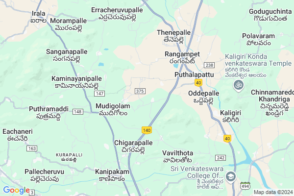
Pambalapalle
Pambalapalle Map
EDIT Map
Add Your House
 ..
..
Current Corona Virus Infected Patients Count in Chittoor District
| City Name | District Name | Total Covid cases |
|---|---|---|
| Chittoor District | Chittoor | 59 |
| Thyagaraja Nagar,Tirupathi | Chittoor | 3 |
| Srikalahasti | Chittoor | 3 |
| Nagiri | Chittoor | 2 |
| Chinna Masjid | Chittoor | 1 |
| Keelapattu nagari | Chittoor | 1 |
| Renigunta | Chittoor | 1 |
| Vadamalapeta | Chittoor | 1 |
| Tirupati | Chittoor | 1 |
| Nindra | Chittoor | 1 |
Locality Name :
Pambalapalle
( పంబలపల్లె )
Mandal Name : Puthalapattu
District : Chittoor
State : Andhra Pradesh
Region : Rayalaseema
Language : Telugu and Urdu
Current Time 06:45 PM
Date: Monday , Apr 28,2025 (IST)
Time zone: IST (UTC+5:30)
Elevation / Altitude: 330 meters. Above Seal level
Telephone Code / Std Code: 08585
Assembly constituency : assembly constituency
Assembly MLA :
Lok Sabha constituency : parliamentary constituency
Parliament MP :
Serpanch Name :
Pin Code : 517124
Post Office Name : Puthalapattu
Main Village Name : Palakuru
Commodities Prices : Chittoor Market / Mandi
Pambalapalle Live Weather
Temperature: 32.2 °C
overcast clouds
Humidity: 33%
Wind : 4.11 mt/sec towards SE
StationName : "Chittoor"
observed on 2 Mins Back
Temperature: 32.2 °C
overcast clouds
Humidity: 33%
Wind : 4.11 mt/sec towards SE
StationName : "Chittoor"
observed on 2 Mins Back
Pambalapalle Weather Forecast for Next 5 days
29-04-2025
25.3°C to 32.9°C
broken clouds, overcast clouds
25.3°C to 32.9°C
broken clouds, overcast clouds
30-04-2025
24.4°C to 38.4°C
broken clouds
24.4°C to 38.4°C
broken clouds
01-05-2025
24.0°C to 39.9°C
broken clouds, scattered clouds, few clouds, clear sky, overcast clouds, light rain
24.0°C to 39.9°C
broken clouds, scattered clouds, few clouds, clear sky, overcast clouds, light rain
02-05-2025
25.8°C to 39.5°C
overcast clouds, broken clouds, light rain, moderate rain
25.8°C to 39.5°C
overcast clouds, broken clouds, light rain, moderate rain
03-05-2025
26.2°C to 39.8°C
overcast clouds, broken clouds, light rain
26.2°C to 39.8°C
overcast clouds, broken clouds, light rain
National Highways Reachable To Pambalapalle
Nationa High Way :NH716B
Nationa High Way :NH716
Nationa High Way :NH716B
Nationa High Way :NH716
Rivers Near Pambalapalle
Pedda Vanka
Ponneri River
Pedda Vanka
Ponneri River
About Pambalapalle
Correct below Info and add more info about PambalapallePambalapalle is a small Village/hamlet in Puthalapattu Mandal in Chittoor District of Andhra Pradesh State, India. It comes under Palakuru Panchayath. It belongs to Rayalaseema region . It is located 16 KM towards North from District head quarters Chittoor. 7 KM from Puthalapattu. 532 KM from State capital Hyderabad
Pambalapalle Pin code is 517124 and postal head office is Puthalapattu .
Pambalapalle is surrounded by Irala Mandal towards west , Penumuru Mandal towards East , Thavanampalle Mandal towards west , Chittoor Mandal towards South .
Chittoor , Sholingur , Vellore , Pallikonda are the near by Cities to Pambalapalle.
Demographics of Pambalapalle
Telugu is the Local Language here. Total population of Pambalapalle is 2445 .Males are 1240 and Females are 1,205 living in 598 Houses. Total area of Pambalapalle is 783 hectares.HOW TO REACH Pambalapalle
By Road
Chittoor is the Nearest Town to Pambalapalle. Chittoor is 22 km from Pambalapalle. Road connectivity is there from Chittoor to Pambalapalle.By Rail
Putalapattu Rail Way Station is the very nearby railway stations to Pambalapalle. Also you can consider railway Stations from Near By town Chittoor. Chittoor Rail Way Station , Siddampalli Rail Way Station are the railway Stations near to Chittoor. You can reach from Chittoor to Pambalapalle by road after .By Bus
Putalpattu APSRTC Bus Station , Patoor APSRTC Bus Station , Chittoor APSRTC Bus Station are the nearby by Bus Stations to Pambalapalle .APSRTC runs Number of busses from major cities to here.Colleges near Pambalapalle
Bheemeshwar Educational Institutions
Address :
Vemu Institute Of Technology
Address : P.kothakota Post, Chittoor Dist - 517 112.
Schools in Pambalapalle
Zphs E.palakuru
Address : palakuru , puthalapattu , chittoor , Andhra Pradesh . PIN- 517124 , Post - Puthalapattu
Govt Health Centers near Pambalapalle
1) PALAKUR , Palakuru S/C , Palakuru , Near Veterinary Center2) MUDIGOLAM , Mudigolam S/C , Mudigolam , Near AW School
3) RANGAMPETA , Rangampeta S/C , Cross Road , Near MPP School
Super Markets in Pambalapalle,Puthalapattu
Police Stations near Pambalapalle,Puthalapattu
Governement Offices near Pambalapalle,Puthalapattu
About Pambalapalle &
History
How to reach Pambalapalle
Tourist Places Near By Pambalapalle
Schools in Pambalapalle
Colleges in Pambalapalle
Temperature & weather of Pambalapalle
places in Pambalapalle
Pambalapalle photos
More Information
How to reach Pambalapalle
Tourist Places Near By Pambalapalle
Schools in Pambalapalle
Colleges in Pambalapalle
Temperature & weather of Pambalapalle
places in Pambalapalle
Pambalapalle photos
More Information
Village Talk
Post News or Events about this Village
Near Cities
Chittoor 14 KM near
Sholingur 50 KM near
Vellore 52 KM near
Pallikonda 53 KM near
Chittoor 14 KM near
Sholingur 50 KM near
Vellore 52 KM near
Pallikonda 53 KM near
Near By Taluks
Irala 7 KM near
Puthalapattu 7 KM near
Thavanampalle 12 KM near
Penumuru 13 KM near
Irala 7 KM near
Puthalapattu 7 KM near
Thavanampalle 12 KM near
Penumuru 13 KM near
Near By Air Ports
Tirupati Airport 69 KM near
Chennai Airport 140 KM near
Bengaluru International Airport 164 KM near
Salem Airport 235 KM near
Tirupati Airport 69 KM near
Chennai Airport 140 KM near
Bengaluru International Airport 164 KM near
Salem Airport 235 KM near
Near By Tourist Places
Chittoor 14 KM near
vellore 52 KM near
Tirupati 57 KM near
Thiruthani 70 KM near
Horsley Hills 89 KM near
Chittoor 14 KM near
vellore 52 KM near
Tirupati 57 KM near
Thiruthani 70 KM near
Horsley Hills 89 KM near
Near By Districts
Chittoor 15 KM near
Vellore 53 KM near
Kanchipuram 98 KM near
Thiruvallur 105 KM near
Chittoor 15 KM near
Vellore 53 KM near
Kanchipuram 98 KM near
Thiruvallur 105 KM near
Near By RailWay Station
Putalapattu Rail Way Station 7.4 KM near
Chittoor Rail Way Station 14 KM near
Pakala Junction Rail Way Station 16 KM near
Putalapattu Rail Way Station 7.4 KM near
Chittoor Rail Way Station 14 KM near
Pakala Junction Rail Way Station 16 KM near