| Home | City Bus | Maps | Villages | Cities | Rail | Tourist Places | School | College | Pin Codes | Corona Cases Count |
| Distance Calculator Bus Services IFSC Codes Trace Mobile Number Weather Search Place Trace IP Available Cash ATM/Banks Locate Polling Booth Report an Error contact People |
Saidapet
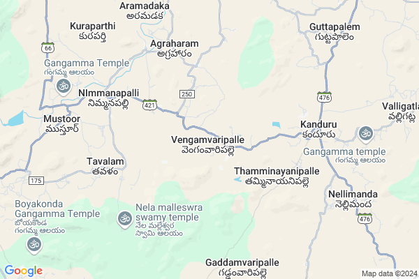
Saidapet Map
EDIT Map
Add Your House
 ..
..
Current Corona Virus Infected Patients Count in Chittoor District
| City Name | District Name | Total Covid cases |
|---|---|---|
| Chittoor District | Chittoor | 59 |
| Thyagaraja Nagar,Tirupathi | Chittoor | 3 |
| Srikalahasti | Chittoor | 3 |
| Nagiri | Chittoor | 2 |
| Keelapattu nagari | Chittoor | 1 |
| Renigunta | Chittoor | 1 |
| Vadamalapeta | Chittoor | 1 |
| Tirupati | Chittoor | 1 |
| Nindra | Chittoor | 1 |
| Chinna Masjid | Chittoor | 1 |
Locality Name :
Saidapet
( సైదాపేట )
Mandal Name : Nimmanapalle
District : Chittoor
State : Andhra Pradesh
Region : Rayalaseema
Language : Telugu and Urdu
Current Time 10:03 AM
Date: Thursday , Apr 24,2025 (IST)
Time zone: IST (UTC+5:30)
Elevation / Altitude: 596 meters. Above Seal level
Telephone Code / Std Code: 08586
Assembly constituency : assembly constituency
Assembly MLA : Mohammed Nawaz Basha
Lok Sabha constituency : parliamentary constituency
Parliament MP : P.V.MIDHUN REDDY
Serpanch Name :
Main Village Name : Vengemvaripalli
Commodities Prices : Vayalapadu Market / Mandi
Edit below overview about Saidapet
Edit below overview about Saidapet
OverView of Saidapet
Saidapet Village is 3km ahead after Nimmanapalle towards Kanduru Road. There are nearly 150 families stayEdit below overview about Saidapet
National Highways Reachable To Saidapet
Nationa High Way :NH42
Nationa High Way :NH71
Nationa High Way :NH42
Nationa High Way :NH71
Rivers Near Saidapet
Cheyyeru River
Kushalavati :ಕುಶಲಾವತಿ
Cheyyeru River
Kushalavati :ಕುಶಲಾವತಿ
About Saidapet
Saidapet is a small Village/hamlet in Nimmanapalle Mandal in Chittoor District of Andhra Pradesh State, India. It comes under Vengemvaripalli Panchayath. It belongs to Rayalaseema region . It is located 64 KM towards west from District head quarters Chittoor. 7 KM from Nimmanapalle. 500 KM from State capital Hyderabad
Saidapet is surrounded by Somala Mandal towards East , Valmikipuram Mandal towards North , Vayalpad Mandal towards North , Chowdepalle Mandal towards South .
Madanapalle , Punganur , Chittoor , Mulbagal are the near by Cities to Saidapet.
Demographics of Saidapet
Telugu is the Local Language here. Total population of Saidapet is 4620 .Males are 2327 and Females are 2,293 living in 1028 Houses. Total area of Saidapet is 3297 hectares.HOW TO REACH Saidapet
By Road
Madanapalle is the Nearest Town to Saidapet. Madanapalle is 32 km from Saidapet. Road connectivity is there from Madanapalle to Saidapet.By Rail
There is no railway station near to Saidapet in less than 10 km.By Bus
Kanduru APSRTC Bus Station , Chinthaparthi APSRTC Bus Station , Somala APSRTC Bus Station are the nearby by Bus Stations to Saidapet .APSRTC runs Number of busses from major cities to here.Pincodes near Saidapet
517280 ( Nimmanapalle ) , 517277 ( Chintaparthi ) , 517234 ( Kalikiri )Colleges near Saidapet
Vani Jr College V.kota Chittoor
Address : Behind Mpdo Office
durga Nagar V.kota
Sri Muninarayana Junior College
Address :
Sree Vidya Arts & Science Degree College.
Address :
Priyadarshini
Address :
Amaravathi Degree College. Ramasamudram
Address : Amaravathi Degree College Ramasamudram
Schools near Saidapet
Zphs Nimmanapalle
Address : nimmanapalle , nimmanapalle , chittoor , Andhra Pradesh . PIN- 517280 , Post - Nimmanapalle
Kgbv - Nimmanapalle
Address : nimmanapalle , nimmanapalle , chittoor , Andhra Pradesh . PIN- 517280 , Post - Nimmanapalle
Zphs Balanayinipalle
Address : vengamvari palli , nimmanapalle , chittoor , Andhra Pradesh . PIN- 517280 , Post - Nimmanapalle
Zphs Reddivaripalle
Address : reddivaripalle , nimmanapalle , chittoor , Andhra Pradesh . PIN- 517325 , Post - Madanapalle
Govt Health Centers near Saidapet
1) Agraharam , , Beside AW centre , Agraharam2) Thavalam , , Main Road , Thavalam Road
3) KANDURU , , Santhathopu , near high school
Schools in Saidapet,Nimmanapalle
Electronic Shops in Saidapet,Nimmanapalle
Super Markets in Saidapet,Nimmanapalle
Local Parks in Saidapet,Nimmanapalle
Police Stations near Saidapet,Nimmanapalle
Governement Offices near Saidapet,Nimmanapalle
About Saidapet &
History
How to reach Saidapet
Tourist Places Near By Saidapet
Schools in Saidapet
Colleges in Saidapet
Temperature & weather of Saidapet
places in Saidapet
Saidapet photos
More Information
How to reach Saidapet
Tourist Places Near By Saidapet
Schools in Saidapet
Colleges in Saidapet
Temperature & weather of Saidapet
places in Saidapet
Saidapet photos
More Information
Village Talk
Post News or Events about this Village
Near Cities
Madanapalle 26 KM near
Punganur 28 KM near
Chittoor 60 KM near
Mulbagal 61 KM near
Madanapalle 26 KM near
Punganur 28 KM near
Chittoor 60 KM near
Mulbagal 61 KM near
Near By Taluks
Nimmanapalle 6 KM near
Valmikipuram 12 KM near
Somala 12 KM near
Vayalpad 15 KM near
Nimmanapalle 6 KM near
Valmikipuram 12 KM near
Somala 12 KM near
Vayalpad 15 KM near
Near By Air Ports
Tirupati Airport 100 KM near
Bengaluru International Airport 130 KM near
Chennai Airport 188 KM near
Salem Airport 245 KM near
Tirupati Airport 100 KM near
Bengaluru International Airport 130 KM near
Chennai Airport 188 KM near
Salem Airport 245 KM near
Near By Tourist Places
Horsley Hills 41 KM near
Chittoor 62 KM near
Tirupati 85 KM near
vellore 93 KM near
Kadapa 114 KM near
Horsley Hills 41 KM near
Chittoor 62 KM near
Tirupati 85 KM near
vellore 93 KM near
Kadapa 114 KM near
Near By Districts
Chittoor 61 KM near
Kolar 87 KM near
Vellore 94 KM near
Cuddapah 114 KM near
Chittoor 61 KM near
Kolar 87 KM near
Vellore 94 KM near
Cuddapah 114 KM near
Near By RailWay Station
Madanapalle Road Rail Way Station 23 KM near
Piler Rail Way Station 28 KM near
Madanapalle Road Rail Way Station 23 KM near
Piler Rail Way Station 28 KM near