| Home | City Bus | Maps | Villages | Cities | Rail | Tourist Places | School | College | Pin Codes | Corona Cases Count |
| Distance Calculator Bus Services IFSC Codes Trace Mobile Number Weather Search Place Trace IP Available Cash ATM/Banks Locate Polling Booth Report an Error contact People |
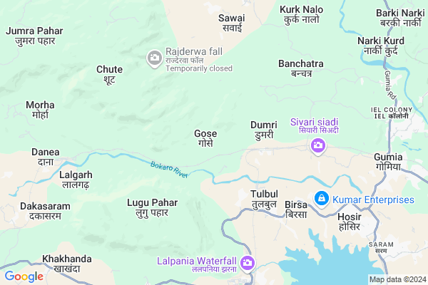
Birhotand Map
EDIT Map
Add Your House
 ..
..
Current Corona Virus Infected Patients Count in Bokaro District
| City Name | District Name | Total Covid cases |
|---|---|---|
| Bokaro District | Bokaro | 10 |
Locality Name :
Birhotand
( बिरहोतांड )
Block Name : Gomia
District : Bokaro
State : Jharkhand
Language : Hindi and Santali
Current Time 01:57 PM
Date: Wednesday , Apr 30,2025 (IST)
Time zone: IST (UTC+5:30)
Elevation / Altitude: 273 meters. Above Seal level
Telephone Code / Std Code: 06544
Assembly constituency : Gomia assembly constituency
Assembly MLA : Lambodar Mahto
Lok Sabha constituency : Giridih parliamentary constituency
Parliament MP : Chandra Prakash Choudhary
Serpanch Name :
Pin Code : 829111
Post Office Name : Gomia
Main Village Name : Gose
Commodities Prices : Khunti Market / Mandi
Birhotand Live Weather
Temperature: 33.8 °C
clear sky
Humidity: 28%
Wind : 3.27 mt/sec towards E
StationName : "Gumia"
observed on 1 Hours Back
Temperature: 33.8 °C
clear sky
Humidity: 28%
Wind : 3.27 mt/sec towards E
StationName : "Gumia"
observed on 1 Hours Back
Birhotand Weather Forecast for Next 5 days
01-05-2025
24.8°C to 35.1°C
few clouds, scattered clouds, light rain, clear sky
24.8°C to 35.1°C
few clouds, scattered clouds, light rain, clear sky
02-05-2025
23.8°C to 35.8°C
clear sky, light rain, overcast clouds
23.8°C to 35.8°C
clear sky, light rain, overcast clouds
03-05-2025
22.9°C to 36.8°C
broken clouds, few clouds, clear sky, scattered clouds
22.9°C to 36.8°C
broken clouds, few clouds, clear sky, scattered clouds
04-05-2025
24.2°C to 37.5°C
scattered clouds, light rain, clear sky
24.2°C to 37.5°C
scattered clouds, light rain, clear sky
05-05-2025
24.0°C to 38.4°C
clear sky, moderate rain, light rain, scattered clouds, overcast clouds
24.0°C to 38.4°C
clear sky, moderate rain, light rain, scattered clouds, overcast clouds
Rivers Near Birhotand
Damodar
Nalkari
Damodar
Nalkari
About Birhotand
Correct below Info and add more info about BirhotandBirhotand is a small Village/hamlet in Gomia Block in Bokaro District of Jharkhand State, India. It comes under Gose Panchayath. It is located 54 KM towards west from District head quarters Bokaro Steel City. 2 KM from Gomia. 79 KM from State capital Ranchi
Birhotand Pin code is 829111 and postal head office is Gomia .
Birhotand is surrounded by Mandu Block towards west , East Singhbum Block towards South , Peterwar Block towards South , Bermo Block towards East .
Gumia , Tenu Dam-cum- Kathhara , Phusro , Ramngarh are the near by Cities to Birhotand.
Demographics of Birhotand
Hindi is the Local Language here.Politics in Birhotand
AJSU Party , AJSUP , AJSU , BJP , JMM , INC are the major political parties in this area.Polling Stations /Booths near Birhotand
1)Ms Kasmar Room No- 22)Ms Dantoo Room No. 1
3)Upgrade Middle School Katam Kulhi
4)U.m.s Katwari Room No - 01
5)U.m.s Tilaiya Room No - 02
HOW TO REACH Birhotand
By Rail
Dumri Bihar Rail Way Station , Danea Rail Way Station are the very nearby railway stations to Birhotand.Colleges near Birhotand
Devi Mahto Memorial Inter Collage Nawadih
Address :
Chandra College Chandra, Chandankiyari
Address :
Chhota Nagpur
Address :
S.e.r.intet College Bhojudih, Bokaro
Address :
R P S College Chandrapura
Address : Chandrapura
Schools near Birhotand
Utkarmik Vidyalay Karmatia
Address : karmatia(swang),gomia
829128
Modern High School, Gomia
Address : Govt. Colony.
I.E. Gomia
PIN 829112
U G M School Jhumra Pahar
Address : jhumra pahar
Hurlung High School Hurlung
Address : vill narkandi
post hurlung
police station Gomia
Dist Bokaro
Govt Health Centers near Birhotand
1) HSC DUMRI , DUMRI , DUMRI , DUMRI2) HSC CHUTTE , CHUTTE , CHUTTE , CHUTTE
3) HSC DANIYA , , ,
Petrol Bunks in Birhotand,Gomia
PREMJI RAMJI MANEK
GOMIA; NEAR IEL FACTORY;BO; Bokaro Steel City; Jharkhand 829211; India
10.7 KM distance Detail
more ..
Schools in Birhotand,Gomia
Ashram Awasiya Vidyalay Tulbul Gomia
Tenughat; Tulbul; Jharkhand 829111; India
4.4 KM distance Detail
Governement Offices near Birhotand,Gomia
Housing Board Office; Gumia
Government Colony Road; Awas Board; Bokaro District; Gumia; Jharkhand 829112; India
11.4 KM distance Detail
About Birhotand &
History
How to reach Birhotand
Tourist Places Near By Birhotand
Schools in Birhotand
Colleges in Birhotand
Temperature & weather of Birhotand
places in Birhotand
Birhotand photos
More Information
How to reach Birhotand
Tourist Places Near By Birhotand
Schools in Birhotand
Colleges in Birhotand
Temperature & weather of Birhotand
places in Birhotand
Birhotand photos
More Information
Village Talk
Post News or Events about this Village
Near Cities
Gumia 10 KM near
Tenu Dam-cum- Kathhara 14 KM near
Phusro 29 KM near
Ramngarh 37 KM near
Gumia 10 KM near
Tenu Dam-cum- Kathhara 14 KM near
Phusro 29 KM near
Ramngarh 37 KM near
Near By Taluks
Gomia 2 KM near
Mandu 20 KM near
Peterwar 22 KM near
East Singhbum 23 KM near
Gomia 2 KM near
Mandu 20 KM near
Peterwar 22 KM near
East Singhbum 23 KM near
Near By Air Ports
Ranchi Airport 77 KM near
Gaya Airport 147 KM near
Patna Airport 234 KM near
Netaji Subhas Chandra Bose Airport 341 KM near
Ranchi Airport 77 KM near
Gaya Airport 147 KM near
Patna Airport 234 KM near
Netaji Subhas Chandra Bose Airport 341 KM near
Near By Tourist Places
Bokaro Steel City 44 KM near
Hazaribagh 46 KM near
Ranchi 76 KM near
Dhanbad 78 KM near
Giridh 78 KM near
Bokaro Steel City 44 KM near
Hazaribagh 46 KM near
Ranchi 76 KM near
Dhanbad 78 KM near
Giridh 78 KM near
Near By Districts
Ramgarh 35 KM near
Hazaribagh 47 KM near
Bokaro 51 KM near
Ranchi 75 KM near
Ramgarh 35 KM near
Hazaribagh 47 KM near
Bokaro 51 KM near
Ranchi 75 KM near
Near By RailWay Station
Dumri Bihar Rail Way Station 2.8 KM near
Ramgarh Cantt. Rail Way Station 34 KM near
Barkakana Junction Rail Way Station 38 KM near
Dumri Bihar Rail Way Station 2.8 KM near
Ramgarh Cantt. Rail Way Station 34 KM near
Barkakana Junction Rail Way Station 38 KM near