| Home | City Bus | Maps | Villages | Cities | Rail | Tourist Places | School | College | Pin Codes | Corona Cases Count |
| Distance Calculator Bus Services IFSC Codes Trace Mobile Number Weather Search Place Trace IP Available Cash ATM/Banks Locate Polling Booth Report an Error contact People |
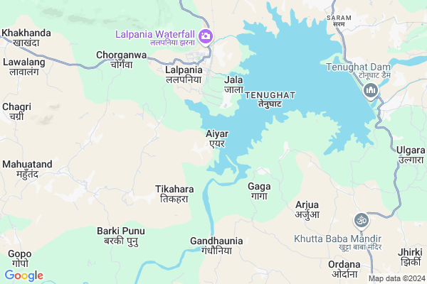
Bathan Tola Map
EDIT Map
Add Your House
 ..
..
Current Corona Virus Infected Patients Count in Bokaro District
| City Name | District Name | Total Covid cases |
|---|---|---|
| Bokaro District | Bokaro | 10 |
Locality Name :
Bathan Tola
( बथान टोला )
Block Name : Gomia
District : Bokaro
State : Jharkhand
Language : Hindi and Santali
Current Time 01:50 PM
Date: Wednesday , Apr 30,2025 (IST)
Time zone: IST (UTC+5:30)
Elevation / Altitude: 273 meters. Above Seal level
Telephone Code / Std Code: 06544
Assembly constituency : Gomia assembly constituency
Assembly MLA : Lambodar Mahto
Lok Sabha constituency : Giridih parliamentary constituency
Parliament MP : Chandra Prakash Choudhary
Serpanch Name :
Main Village Name : Aiyar
Commodities Prices : Khunti Market / Mandi
Rivers Near Bathan Tola
Damodar
Nalkari
Damodar
Nalkari
About Bathan Tola
Correct below Info and add more info about Bathan TolaBathan Tola is a small Village/hamlet in Gomia Block in Bokaro District of Jharkhand State, India. It comes under Aiyar Panchayath. It is located 49 KM towards west from District head quarters Bokaro Steel City. 11 KM from Gomia. 72 KM from State capital Ranchi
Bathan Tola is surrounded by Peterwar Block towards East , East Singhbum Block towards west , Bermo Block towards East , Gola Block towards South .
Tenu Dam-cum- Kathhara , Gumia , Phusro , Ramngarh are the near by Cities to Bathan Tola.
Demographics of Bathan Tola
Hindi is the Local Language here.Politics in Bathan Tola
AJSU Party , AJSUP , AJSU , BJP , JMM , INC are the major political parties in this area.Polling Stations /Booths near Bathan Tola
1)Ms Dantoo Room No. 12)Upgrade Middle School Katam Kulhi
3)Ms Kasmar Room No- 2
4)Panchayat Bhawan Sadam. Room No - 01
5)P.s Devipur Room No - 01
HOW TO REACH Bathan Tola
By Rail
There is no railway station near to Bathan Tola in less than 10 km.Pincodes near Bathan Tola
829149 ( T.T.P.S.Lalpania ) , 829127 ( Sunday Bazar ) , 829123 ( Tenughat Dam )Colleges near Bathan Tola
Devi Mahto Memorial Inter Collage Nawadih
Address :
Chandra College Chandra, Chandankiyari
Address :
Chhota Nagpur
Address :
S.e.r.intet College Bhojudih, Bokaro
Address :
R P S College Chandrapura
Address : Chandrapura
Schools near Bathan Tola
Utkarmik Vidyalay Karmatia
Address : karmatia(swang),gomia
829128
Modern High School, Gomia
Address : Govt. Colony.
I.E. Gomia
PIN 829112
U G M School Jhumra Pahar
Address : jhumra pahar
Hurlung High School Hurlung
Address : vill narkandi
post hurlung
police station Gomia
Dist Bokaro
Govt Health Centers near Bathan Tola
1) HSC KERI , , ,2) HSC TIKAHARA , TIKAHARA , TIKAHARA , TIKAHARA
3) HSC ARJUA , arjua , ,
Hospitals in Bathan Tola,Gomia
FIRST-AID CENTER GOVT HOSPITAL SARAM
Tenughat; Saram; Jharkhand 829111; India
9.7 KM distance Detail
more ..
Petrol Bunks in Bathan Tola,Gomia
HP PETROL PUMP - DEOKI FUEL STATION
Hpcl Petrol Pump; Nh-23;lepo PO -peterwar PS -peterwar; Ranchi; Jharkhand 829121; India
14.4 KM distance Detail
more ..
Schools in Bathan Tola,Gomia
उत्क्रमित मध्य विद्यालय Gandhouniya
Tenughat; Gandhaunia; Jharkhand 829110; India
5.8 KM distance Detail
About Bathan Tola &
History
How to reach Bathan Tola
Tourist Places Near By Bathan Tola
Schools in Bathan Tola
Colleges in Bathan Tola
Temperature & weather of Bathan Tola
places in Bathan Tola
Bathan Tola photos
More Information
How to reach Bathan Tola
Tourist Places Near By Bathan Tola
Schools in Bathan Tola
Colleges in Bathan Tola
Temperature & weather of Bathan Tola
places in Bathan Tola
Bathan Tola photos
More Information
Village Talk
Post News or Events about this Village
Near Cities
Tenu Dam-cum- Kathhara 12 KM near
Gumia 13 KM near
Phusro 27 KM near
Ramngarh 33 KM near
Tenu Dam-cum- Kathhara 12 KM near
Gumia 13 KM near
Phusro 27 KM near
Ramngarh 33 KM near
Near By Taluks
Gomia 10 KM near
Peterwar 12 KM near
East Singhbum 17 KM near
Gola 22 KM near
Gomia 10 KM near
Peterwar 12 KM near
East Singhbum 17 KM near
Gola 22 KM near
Near By Air Ports
Ranchi Airport 69 KM near
Gaya Airport 158 KM near
Patna Airport 246 KM near
Netaji Subhas Chandra Bose Airport 334 KM near
Ranchi Airport 69 KM near
Gaya Airport 158 KM near
Patna Airport 246 KM near
Netaji Subhas Chandra Bose Airport 334 KM near
Near By Tourist Places
Bokaro Steel City 38 KM near
Hazaribagh 57 KM near
Ranchi 68 KM near
Dassam Falls 71 KM near
Dhanbad 77 KM near
Bokaro Steel City 38 KM near
Hazaribagh 57 KM near
Ranchi 68 KM near
Dassam Falls 71 KM near
Dhanbad 77 KM near
Near By Districts
Ramgarh 31 KM near
Bokaro 47 KM near
Hazaribagh 56 KM near
Ranchi 68 KM near
Ramgarh 31 KM near
Bokaro 47 KM near
Hazaribagh 56 KM near
Ranchi 68 KM near
Near By RailWay Station
Ramgarh Cantt. Rail Way Station 29 KM near
Barkakana Junction Rail Way Station 34 KM near
Ramgarh Cantt. Rail Way Station 29 KM near
Barkakana Junction Rail Way Station 34 KM near