| Home | City Bus | Maps | Villages | Cities | Rail | Tourist Places | School | College | Pin Codes | Corona Cases Count |
| Distance Calculator Bus Services IFSC Codes Trace Mobile Number Weather Search Place Trace IP Available Cash ATM/Banks Locate Polling Booth Report an Error contact People |
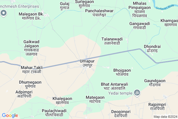
Umapur
Umapur Map
EDIT Map
Add Your House
 ..
..
Current Corona Virus Infected Patients Count in Beed District
| City Name | District Name | Total Covid cases |
|---|
Locality Name :
Umapur
( उमापूर )
Taluka Name : Georai
District : Beed
State : Maharashtra
Region : Marathwada
Division : Aurangabad
Language : English and Hindi, Marathi
Current Time 10:55 AM
Date: Tuesday , Apr 29,2025 (IST)
Time zone: IST (UTC+5:30)
Elevation / Altitude: 473 meters. Above Seal level
Telephone Code / Std Code: 02447
Assembly constituency : Georai assembly constituency
Assembly MLA : Laxman Madhavrao Pawar
Lok Sabha constituency : Beed parliamentary constituency
Parliament MP : Pritam Gopinathrao Munde
Serpanch Name :
Pin Code : 431130
Post Office Name : Umapur
Commodities Prices : Gevrai Market / Mandi
Edit below overview about Umapur
Edit below overview about Umapur
OverView of Umapur
Umapur is the head office of nearhy 15 villages. This is one of the largest village in Beed District.Edit below overview about Umapur
Rivers Near Umapur
Ashti
Nani
Ashti
Nani
About Umapur
Umapur is a Village in Georai Taluka in Beed District of Maharashtra State, India. It belongs to Marathwada region . It belongs to Aurangabad Division . It is located 44 KM towards North from District head quarters Beed. 21 KM from Takalgaon T.Georai. 338 KM from State capital Mumbai
Umapur Pin code is 431130 and postal head office is Umapur .
Bhat Antarwali ( 5 KM ) , Bhojgaon ( 5 KM ) , Khalegaon ( 6 KM ) , Panchaleshwar ( 7 KM ) , Gaikwad Jalgaon ( 8 KM ) are the nearby Villages to Umapur. Umapur is surrounded by Shevgaon Taluka towards west , Shirur ( Ka ) Taluka towards South , Ambad Taluka towards North , Paithan Taluka towards North .
Paithan , Pathardi , Jalna , Manjlegaon are the near by Cities to Umapur.
Umapur 2011 Census Details
Umapur Local Language is English. Umapur Village Total population is 8479 and number of houses are 1636. Female Population is 48.8%. Village literacy rate is 62.2% and the Female Literacy rate is 26.6%.
Population
| Census Parameter | Census Data |
| Total Population | 8479 |
| Total No of Houses | 1636 |
| Female Population % | 48.8 % ( 4134) |
| Total Literacy rate % | 62.2 % ( 5272) |
| Female Literacy rate | 26.6 % ( 2259) |
| Scheduled Tribes Population % | 0.4 % ( 33) |
| Scheduled Caste Population % | 22.0 % ( 1863) |
| Working Population % | 56.0 % |
| Child(0 -6) Population by 2011 | 1250 |
| Girl Child(0 -6) Population % by 2011 | 46.5 % ( 581) |
Umapur Census More Deatils.
Politics in Umapur
Bharatiya Janata Party , BJP , NCP are the major political parties in this area.Polling Stations /Booths near Umapur
1)Borgaon Thadi2)Bhandgwadi
3)Gangawadi T. Talwada
4)Padalsingi
5)Gadhi
HOW TO REACH Umapur
By Rail
There is no railway station near to Umapur in less than 10 km. are the Rail way stations reachable from near by towns.By Road
Bid , Georai , Manjlegaon are the nearby by towns to Umapur having road connectivity to UmapurColleges near Umapur
Janvikas Mahavidyalaya Bansarola
Address :
Kailas Kala Niketan,beed
Address :
Arts, Science And Commerce College Amalner !
Address :
Pt.javaharlal Nehru Jr.collage Ashti
Address :
Sahyadri Iti & Enggering
Address :
Schools in Umapur
Madhyamik Vid Umapur
Address : umapur , georai , bid , Maharashtra . PIN- 431130 , Post - Umapur
Urdu Madhyamik Vid Umapur
Address : umapur , georai , bid , Maharashtra . PIN- 431130 , Post - Umapur
Zphs Umapur
Address : umapur , georai , bid , Maharashtra . PIN- 431130 , Post - Umapur
Govt Health Centers near Umapur
1) Umapur , Primary Health Centre Umapur , ,2) Antarvali , sub Centre Antarvali , ,
3) GAIKWAD JALGAON , SUBCENTER GAIKWAD JALGAON , GAVTHAN , NEAR MANDIR
Petrol Bunks in Umapur,Georai
Bharat Petroleum
Umapur; Bid; SH-44; Thane Ahmednagar Parbhani Highway; Beed; Beed; Maharashtra 431130; India
0.2 KM distance Detail
Reliance Petroleum
NH-4 CHAINAGE NUMBER 813 AT POST KELAWDE BHOR DISTRICT- PUNE 412213 Khedshivapur; Maharashtra 411019; India
11.0 KM distance Detail
Bharat Petroleum
Georai; Bid; NH-211; Solapur Aurangabad Highway; Beed; Beed; Maharashtra 431127; India
15.2 KM distance Detail
more ..
Colleges in Umapur,Georai
Art & Sci College Chaklamba
Georai - Chaklamba Rd; Georai; Maharashtra 431127; India
15.2 KM distance Detail
more ..
Local Parks in Umapur,Georai
Naik Nagar Park
Naik Rd; Naik Nagar; Gajanan Nagar; Georai; Maharashtra 431127; India
18.9 KM distance Detail
Governement Offices near Umapur,Georai
Irrigation Department Office
Jayakwadi Colony; Georai; Maharashtra 431127; India
19.8 KM distance Detail
Friend's Scrap Sentar
friend's Scrap Sentar; Jayakwadi Colony; Georai; Maharashtra 431127; India
19.8 KM distance Detail
About Umapur &
History
How to reach Umapur
Tourist Places Near By Umapur
Schools in Umapur
Colleges in Umapur
Temperature & weather of Umapur
places in Umapur
Umapur photos
More Information
How to reach Umapur
Tourist Places Near By Umapur
Schools in Umapur
Colleges in Umapur
Temperature & weather of Umapur
places in Umapur
Umapur photos
More Information
Village Talk
Post News or Events about this Village
Near Cities
Paithan 32 KM near
Pathardi 52 KM near
Jalna 75 KM near
Manjlegaon 76 KM near
Paithan 32 KM near
Pathardi 52 KM near
Jalna 75 KM near
Manjlegaon 76 KM near
Near By Taluks
Georai 20 KM near
Shevgaon 35 KM near
Ambad 36 KM near
Shirur ( Ka ) 36 KM near
Georai 20 KM near
Shevgaon 35 KM near
Ambad 36 KM near
Shirur ( Ka ) 36 KM near
Near By Air Ports
Chikkalthana Airport 74 KM near
Latur Airport 150 KM near
Nanded Airport 202 KM near
Sholapur Airport 211 KM near
Chikkalthana Airport 74 KM near
Latur Airport 150 KM near
Nanded Airport 202 KM near
Sholapur Airport 211 KM near
Near By Tourist Places
Aurangabad 79 KM near
Grishneshwar 103 KM near
Ahmednagar 105 KM near
Shirdi 146 KM near
Tuljapur 169 KM near
Aurangabad 79 KM near
Grishneshwar 103 KM near
Ahmednagar 105 KM near
Shirdi 146 KM near
Tuljapur 169 KM near
Near By Districts
Beed 43 KM near
Jalna 75 KM near
Aurangabad District 78 KM near
Ahmednagar 104 KM near
Beed 43 KM near
Jalna 75 KM near
Aurangabad District 78 KM near
Ahmednagar 104 KM near
Near By RailWay Station
Jalna Rail Way Station 74 KM near
Aurangabad Rail Way Station 77 KM near
Jalna Rail Way Station 74 KM near
Aurangabad Rail Way Station 77 KM near