| Home | City Bus | Maps | Villages | Cities | Rail | Tourist Places | School | College | Pin Codes | Corona Cases Count |
| Distance Calculator Bus Services IFSC Codes Trace Mobile Number Weather Search Place Trace IP Available Cash ATM/Banks Locate Polling Booth Report an Error contact People |
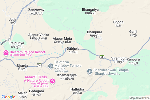
Dabhela
Dabhela Map
EDIT Map
Add Your House
 ..
..
Current Corona Virus Infected Patients Count in Banas Kantha District
| City Name | District Name | Total Covid cases |
|---|
Locality Name :
Dabhela
( ડાભેલ )
Taluka Name : Amirgadh
District : Banas Kantha
State : Gujarat
Language : Gujarati and Hindi
Current Time 01:14 AM
Date: Tuesday , Mar 04,2025 (IST)
Time zone: IST (UTC+5:30)
Elevation / Altitude: 216 meters. Above Seal level
Telephone Code / Std Code: 02749
Assembly constituency : Danta assembly constituency
Assembly MLA : Kantibhai Kalabhai Kharadi
Lok Sabha constituency : Banaskantha parliamentary constituency
Parliament MP : PARBATBHAI SAVABHAI PATEL
Serpanch Name :
Pin Code : 385410
Post Office Name : Vadgam
Commodities Prices : Amirgadh Market / Mandi
Dabhela Live Weather
Temperature: 20.1 °C
clear sky
Humidity: 49%
Wind : 1.34 mt/sec towards NW
StationName : "PÄ\u0081lanpur"
observed on 9 Mins Back
Temperature: 20.1 °C
clear sky
Humidity: 49%
Wind : 1.34 mt/sec towards NW
StationName : "PÄ\u0081lanpur"
observed on 9 Mins Back
Dabhela Weather Forecast for Next 5 days
04-03-2025
19.3°C to 19.3°C
scattered clouds
19.3°C to 19.3°C
scattered clouds
05-03-2025
14.6°C to 29.5°C
scattered clouds, broken clouds, clear sky
14.6°C to 29.5°C
scattered clouds, broken clouds, clear sky
06-03-2025
13.3°C to 31.4°C
clear sky, scattered clouds, overcast clouds, broken clouds
13.3°C to 31.4°C
clear sky, scattered clouds, overcast clouds, broken clouds
07-03-2025
17.2°C to 33.3°C
clear sky
17.2°C to 33.3°C
clear sky
08-03-2025
19.2°C to 35.5°C
clear sky
19.2°C to 35.5°C
clear sky
Rivers Near Dabhela
Kapra
Sipu
Kapra
Sipu
About Dabhela
Correct below Info and add more info about DabhelaDabhela is a Village in Amirgadh Taluka in Banas Kantha District of Gujarat State, India. It is located 24 KM towards East from District head quarters Palanpur. 8 KM from Amirgadh. 136 KM from State capital Gandhinagar
Dabhela Pin code is 385410 and postal head office is Vadgam .
Dhanpura (vi) ( 2 KM ) , Surela ( 4 KM ) , Khemarajiya ( 4 KM ) , Hathidra ( 6 KM ) , Zanzarvav ( 8 KM ) are the nearby Villages to Dabhela. Dabhela is surrounded by Banas Kantha Taluka towards west , Palanpur Taluka towards west , Vadgam Taluka towards South , Abu Road Taluka towards North .
Palanpur , Mount Abu , Deesa , Kheralu are the near by Cities to Dabhela.
This Place is in the border of the Banas Kantha District and Sirohi District. Sirohi District Abu Road is North towards this place . It is near to the Rajasthan State Border.
Dabhela 2011 Census Details
Dabhela Local Language is Gujarati. Dabhela Village Total population is 3269 and number of houses are 637. Female Population is 50.3%. Village literacy rate is 50.9% and the Female Literacy rate is 18.7%.
Population
| Census Parameter | Census Data |
| Total Population | 3269 |
| Total No of Houses | 637 |
| Female Population % | 50.3 % ( 1643) |
| Total Literacy rate % | 50.9 % ( 1663) |
| Female Literacy rate | 18.7 % ( 612) |
| Scheduled Tribes Population % | 6.3 % ( 206) |
| Scheduled Caste Population % | 8.3 % ( 270) |
| Working Population % | 40.4 % |
| Child(0 -6) Population by 2011 | 533 |
| Girl Child(0 -6) Population % by 2011 | 46.9 % ( 250) |
Dabhela Census More Deatils.
Politics in Dabhela
Bharatiya Janata Party , BJP , INC are the major political parties in this area.Polling Stations /Booths near Dabhela
1)Bhdramal2)Dabhelee
3)Gangava-2
4)Ganji
5)Dabhela-2
HOW TO REACH Dabhela
By Rail
Jethi Rail Way Station , Iqbal Gadh Rail Way Station are the very nearby railway stations to Dabhela.Colleges near Dabhela
Vimla Vikas Vartul Gadh
Address :
D.n.p. Arts&com.college Deesa
Address :
I.t.i Collage Morthal
Address : Gram Panchayat Morthal
Dharti Education Academy , Tharad
Address : 2nd Floor, Jalaram Complex, Near Bus Station, Tharad, Banaskantha, 385565
Bkm Law College
Address : Opp.s.t.work Shop, Highway,palanpur,dist.banaskant
Schools in Dabhela
Dabhela Pri. Sch.
Address : dabhela , amirgadh , banas kantha , Gujarat . PIN- 385130 , Post - Shri Amirgadh
Govt Health Centers near Dabhela
1) Amirgadh - T , CHC AMIRGADH , CHC AMIRGADH , CHC AMIRGADH ROAD2) VIRAMPUR , NEAR BUS STAND , NEAR BUS STAND , NEAR BUS STAND
3) Moriya , CHC Building , On Mumanvas road , Near water tank
Hospitals in Dabhela,Amirgadh
Prathmik Arogya Kendra
Amirgarh; Banaskantha; SH-54; Banaskantha Road; Banaskantha; Banaskantha; Gujarat 385001; India
7.4 KM distance Detail
more ..
Petrol Bunks in Dabhela,Amirgadh
HP PETROL PUMP - AMANTRAN FILLING STATION
HP Petrol Pump SH54 Chitrasani Ambaji Highway Virampur; Ahmedabad; Gujarat 385001; India
7.0 KM distance Detail
Hindustan Petroleum
Banaskantha; SH-54; Banaskantha Road; Banaskantha; Banaskantha; Gujarat 385001; India
7.0 KM distance Detail
Indian Oil Petrol Pump
NH-14; Banaskantha Road; Banaskantha; Palanpur; Gujarat 385130; India
10.5 KM distance Detail
more ..
Colleges in Dabhela,Amirgadh
Shri BKPSM Post Graduate College Of Medicine
Arvind Marg; Jagana Road; Banaskantha; Palanpur; Gujarat 385001; India
22.4 KM distance Detail
more ..
Local Parks in Dabhela,Amirgadh
Stone Aartijan Park
Ambaji Hwy; Amirbag; Maheshwari Colony; Palanpur; Gujarat 385001; India
22.1 KM distance Detail
Hello Point Garden Restaurant
Near Gayatri Mandir; Ahmedabad Highway; Tirupati Rajnagar; Palanpur; Gujarat 385001; India
22.9 KM distance Detail
Police Stations near Dabhela,Amirgadh
Banaskantha District Police Station
NH 27; Maheshwari Colony; Palanpur; Gujarat 385001; India
22.3 KM distance Detail
Palanpur Taluka Police Station
Maheshwari Colony; Palanpur; Gujarat 385001; India
22.4 KM distance Detail
Governement Offices near Dabhela,Amirgadh
Jagruti Agriculture & Eng. Works
Palanpur - Danta Rd; Jalotra; Gujarat 385410; India
17.9 KM distance Detail
About Dabhela &
History
How to reach Dabhela
Tourist Places Near By Dabhela
Schools in Dabhela
Colleges in Dabhela
Temperature & weather of Dabhela
places in Dabhela
Dabhela photos
More Information
How to reach Dabhela
Tourist Places Near By Dabhela
Schools in Dabhela
Colleges in Dabhela
Temperature & weather of Dabhela
places in Dabhela
Dabhela photos
More Information
Village Talk
Post News or Events about this Village
Near Cities
Palanpur 21 KM near
Mount Abu 40 KM near
Deesa 45 KM near
Kheralu 48 KM near
Palanpur 21 KM near
Mount Abu 40 KM near
Deesa 45 KM near
Kheralu 48 KM near
Near By Taluks
Amirgadh 8 KM near
Banas Kantha 23 KM near
Palanpur 25 KM near
Vadgam 30 KM near
Amirgadh 8 KM near
Banas Kantha 23 KM near
Palanpur 25 KM near
Vadgam 30 KM near
Near By Air Ports
Ahmedabad Airport 151 KM near
Dabok Airport 152 KM near
Jodhpur Airport 252 KM near
Vadodara Airport 252 KM near
Ahmedabad Airport 151 KM near
Dabok Airport 152 KM near
Jodhpur Airport 252 KM near
Vadodara Airport 252 KM near
Near By Tourist Places
Danta Ambaji 20 KM near
Banaskantha 23 KM near
Ambaji 28 KM near
Mount Abu 40 KM near
Patan 78 KM near
Danta Ambaji 20 KM near
Banaskantha 23 KM near
Ambaji 28 KM near
Mount Abu 40 KM near
Patan 78 KM near
Near By Districts
Banas Kantha 23 KM near
Patan 76 KM near
Sirohi 80 KM near
Mahesana 87 KM near
Banas Kantha 23 KM near
Patan 76 KM near
Sirohi 80 KM near
Mahesana 87 KM near
Near By RailWay Station
Palanpur Junction Rail Way Station 23 KM near
Abu Road Rail Way Station 32 KM near
Palanpur Junction Rail Way Station 23 KM near
Abu Road Rail Way Station 32 KM near