| Home | City Bus | Maps | Villages | Cities | Rail | Tourist Places | School | College | Pin Codes | Corona Cases Count |
| Distance Calculator Bus Services IFSC Codes Trace Mobile Number Weather Search Place Trace IP Available Cash ATM/Banks Locate Polling Booth Report an Error contact People |
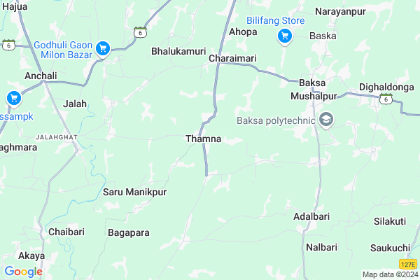
Thamna Map
EDIT Map
Add Your House
 ..
..
Current Corona Virus Infected Patients Count in Baksa District
| City Name | District Name | Total Covid cases |
|---|
Locality Name :
Thamna
( थामना )
Tehsil Name : Baska
District : Baksa
State : Assam
Language : Assamese and Bengali, Bodo
Current Time 05:49 AM
Date: Saturday , Apr 26,2025 (IST)
Time zone: IST (UTC+5:30)
Elevation / Altitude: 46 meters. Above Seal level
Telephone Code / Std Code: 03623
Assembly constituency : Chapaguri assembly constituency
Assembly MLA :
Lok Sabha constituency : Kokrajhar parliamentary constituency
Parliament MP :
Serpanch Name :
Pin Code : 781377
Post Office Name : Thamna (Nalbari)
Thamna Live Weather
Temperature: 21.4 °C
clear sky
Humidity: 73%
Wind : 2.1 mt/sec towards NE
StationName : "Samdrup Jongkhar"
observed on 1 Hours Back
Temperature: 21.4 °C
clear sky
Humidity: 73%
Wind : 2.1 mt/sec towards NE
StationName : "Samdrup Jongkhar"
observed on 1 Hours Back
Thamna Weather Forecast for Next 5 days
27-04-2025
21.0°C to 36.8°C
light rain, clear sky
21.0°C to 36.8°C
light rain, clear sky
28-04-2025
21.1°C to 37.8°C
light rain, clear sky, scattered clouds, heavy intensity rain
21.1°C to 37.8°C
light rain, clear sky, scattered clouds, heavy intensity rain
29-04-2025
21.9°C to 34.4°C
overcast clouds, broken clouds, few clouds, light rain
21.9°C to 34.4°C
overcast clouds, broken clouds, few clouds, light rain
30-04-2025
20.7°C to 33.2°C
overcast clouds, broken clouds, light rain, moderate rain
20.7°C to 33.2°C
overcast clouds, broken clouds, light rain, moderate rain
Edit below overview about Thamna
Edit below overview about Thamna
OverView of Thamna
Thamna is a village 3 kM west from Baksa district head quarter of Mushalpur.the roads pattern of the village is like branches of trees.it means so many road connect in the village.at time of revolution of Bhutiya lifting people gathered here and started to fighting among bhutiya and force to left from Assam .in ancient time people call thepna which now revoled 'Thamna'.Edit below overview about Thamna
Rivers Near Thamna
Jia Ber Nadi
Pagladia
Jia Ber Nadi
Pagladia
About Thamna
Thamna is a Village in Baska Tehsil in Baksa District of Assam State, India. It is located 30 KM towards west from District head quarters Mushalpur. 2 KM from Baska. 82 KM from State capital Dispur
Thamna Pin code is 781377 and postal head office is Thamna (Nalbari).
Jalah ( 7 KM ) , Baksa ( 8 KM ) , Baska ( 8 KM ) , Chaibari ( 9 KM ) , Jalagaon ( 10 KM ) are the nearby Villages to Thamna. Thamna is surrounded by Jalah Tehsil towards west , Barama Tehsil towards East , Tihu Tehsil towards South , Dhamdhama Tehsil towards East .
Nalbari , Barpeta Road , Rangia , Barpeta are the near by Cities to Thamna.
Thamna 2011 Census Details
Thamna Local Language is Assamese. Thamna Village Total population is 1755 and number of houses are 398. Female Population is 50.4%. Village literacy rate is 80.7% and the Female Literacy rate is 39.1%.
Population
| Census Parameter | Census Data |
| Total Population | 1755 |
| Total No of Houses | 398 |
| Female Population % | 50.4 % ( 884) |
| Total Literacy rate % | 80.7 % ( 1416) |
| Female Literacy rate | 39.1 % ( 687) |
| Scheduled Tribes Population % | 6.0 % ( 106) |
| Scheduled Caste Population % | 3.7 % ( 65) |
| Working Population % | 39.7 % |
| Child(0 -6) Population by 2011 | 147 |
| Girl Child(0 -6) Population % by 2011 | 48.3 % ( 71) |
Thamna Census More Deatils.
Politics in Thamna
Independent , 56651 , BPF , BOPF , 83.17% are the major political parties in this area.Polling Stations /Booths near Thamna
1)Thamna Binapani High School (l/w)2)Thamna Binapani High School (m/w)
3)Tatlapara L.p. School (r/w)
4)Gadhuligaon L.p. School (r/w)
5)Uzirbari Lp School (lw)
HOW TO REACH Thamna
By Rail
There is no railway station near to Thamna in less than 10 km.Schools in Thamna
Thamna Binapani High School
Address : Village : Thamna, P.O.: Thamna
Govt Health Centers near Thamna
1) MURMELA SC , Bholanath Murmela Sub Centre , Kadamtala Mushalpur Road , Near Shiv Mandir2) KHARUAJAN SC , , Barama - Pakhamara Road , Near Kharujan L.P School
3) Tukrakuchi SC , Tukrakuchi Building , Tukrakuchi Sector , TUKRAKUCHI MAJARSUPA PRIMARY School
Hospitals in Thamna,Baska
Sub Health Centre
Charana Bazar; Kathalmuri; Baksa; NH-152; Baksa; Baksa; Assam 781328; India
12.3 KM distance Detail
more ..
Electronic Shops in Thamna,Baska
Dipanjoli Electric
Saudarvitha - Baghmara Rd; Pub Kathal Muri; Assam 781328; India
12.5 KM distance Detail
Local Parks in Thamna,Baska
About Thamna &
History
How to reach Thamna
Tourist Places Near By Thamna
Schools in Thamna
Colleges in Thamna
Temperature & weather of Thamna
places in Thamna
Thamna photos
More Information
How to reach Thamna
Tourist Places Near By Thamna
Schools in Thamna
Colleges in Thamna
Temperature & weather of Thamna
places in Thamna
Thamna photos
More Information
Village Talk
Post News or Events about this Village
Near Cities
Nalbari 31 KM near
Barpeta Road 39 KM near
Rangia 43 KM near
Barpeta 51 KM near
Nalbari 31 KM near
Barpeta Road 39 KM near
Rangia 43 KM near
Barpeta 51 KM near
Near By Taluks
Baska 2 KM near
Jalah 13 KM near
Barama 15 KM near
Dhamdhama 15 KM near
Baska 2 KM near
Jalah 13 KM near
Barama 15 KM near
Dhamdhama 15 KM near
Near By Air Ports
Borjhar Airport 74 KM near
Shillong Airport 149 KM near
Rupsi Airport 164 KM near
Salonibari Airport 167 KM near
Borjhar Airport 74 KM near
Shillong Airport 149 KM near
Rupsi Airport 164 KM near
Salonibari Airport 167 KM near
Near By Tourist Places
Nalbari 29 KM near
Manas National Park 32 KM near
Barpeta 40 KM near
Hajo 54 KM near
Guwahati 78 KM near
Nalbari 29 KM near
Manas National Park 32 KM near
Barpeta 40 KM near
Hajo 54 KM near
Guwahati 78 KM near
Near By Districts
Baksa 29 KM near
Nalbari 29 KM near
Chirang 43 KM near
Barpeta 51 KM near
Baksa 29 KM near
Nalbari 29 KM near
Chirang 43 KM near
Barpeta 51 KM near
Near By RailWay Station
Nalbari Rail Way Station 28 KM near
Barpeta Road Rail Way Station 40 KM near
Nalbari Rail Way Station 28 KM near
Barpeta Road Rail Way Station 40 KM near