| Home | City Bus | Maps | Villages | Cities | Rail | Tourist Places | School | College | Pin Codes | Corona Cases Count |
| Distance Calculator Bus Services IFSC Codes Trace Mobile Number Weather Search Place Trace IP Available Cash ATM/Banks Locate Polling Booth Report an Error contact People |
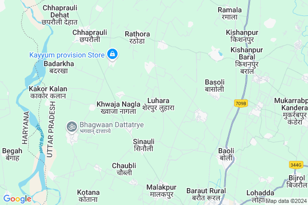
Luhara
Luhara Map
EDIT Map
Add Your House
 ..
..
Current Corona Virus Infected Patients Count in Baghpat District
| City Name | District Name | Total Covid cases |
|---|---|---|
| Baghpat District | Baghpat | 14 |
| Baghpat | Baghpat | 1 |
Locality Name :
Luhara
( लुहारा )
Block Name : Chhaprauli
District : Baghpat
State : Uttar Pradesh
Division : Meerut
Language : Hindi and Urdu
Current Time 01:54 PM
Date: Monday , Apr 28,2025 (IST)
Time zone: IST (UTC+5:30)
Elevation / Altitude: 234 meters. Above Seal level
Telephone Code / Std Code: 01398
Assembly constituency : Chhaprauli assembly constituency
Assembly MLA : Ajay Kumar
Lok Sabha constituency : Baghpat parliamentary constituency
Parliament MP : Dr. SATYAPAL SINGH
Serpanch Name :
Pin Code : 250617
Post Office Name : Chhaprauli
Commodities Prices : Baraut Market / Mandi
Luhara Live Weather
Temperature: 38.9 °C
clear sky
Humidity: 10%
Wind : 4.07 mt/sec towards SE
StationName : "Chhaprauli"
observed on 2 Hours Back
Temperature: 38.9 °C
clear sky
Humidity: 10%
Wind : 4.07 mt/sec towards SE
StationName : "Chhaprauli"
observed on 2 Hours Back
Luhara Weather Forecast for Next 5 days
29-04-2025
29.5°C to 41.4°C
clear sky
29.5°C to 41.4°C
clear sky
30-04-2025
25.8°C to 42.0°C
clear sky, few clouds
25.8°C to 42.0°C
clear sky, few clouds
01-05-2025
26.9°C to 41.7°C
clear sky, few clouds
26.9°C to 41.7°C
clear sky, few clouds
02-05-2025
29.2°C to 41.2°C
broken clouds, overcast clouds, clear sky, scattered clouds
29.2°C to 41.2°C
broken clouds, overcast clouds, clear sky, scattered clouds
03-05-2025
28.0°C to 39.0°C
broken clouds, light rain, overcast clouds, scattered clouds, few clouds, clear sky
28.0°C to 39.0°C
broken clouds, light rain, overcast clouds, scattered clouds, few clouds, clear sky
Edit below overview about Luhara
Edit below overview about Luhara
OverView of Luhara
It is situated 10 KM from Baraut .It is famous for Baba Banasura Temple situated in the heart of village.Edit below overview about Luhara
National Highways Reachable To Luhara
Nationa High Way :NH334
Nationa High Way :NH44
Nationa High Way :NH334
Nationa High Way :NH44
Rivers Near Luhara
Hindon River
Hindon River
About Luhara
Luhara is a Village in Chhaprauli Block in Baghpat District of Uttar Pradesh State, India. It belongs to Meerut Division . It is located 28 KM towards North from District head quarters Bagpat. 6 KM from Chhaprauli. 523 KM from State capital Lucknow
Luhara Pin code is 250617 and postal head office is Chhaprauli .
Khwaja Nagla ( 2 KM ) , Khwajgipur Urf Chandanheri ( 2 KM ) , Barwala ( 3 KM ) , Sadakpur Sinoli ( 3 KM ) , Silana ( 3 KM ) are the nearby Villages to Luhara. Luhara is surrounded by Baraut Block towards East , Binauli Block towards East , Baghpat Block towards South , Samalkha Block towards west .
Ganaur , Samalkha , Sonipat , Shamli are the near by Cities to Luhara.
This Place is in the border of the Baghpat District and Panipat District. Panipat District Samalkha is west towards this place . Also it is in the Border of other district Muzaffarnagar . It is near to the Haryana State Border.
Luhara 2011 Census Details
Luhara Local Language is Hindi. Luhara Village Total population is 4492 and number of houses are 713. Female Population is 45.9%. Village literacy rate is 63.9% and the Female Literacy rate is 24.3%.
Population
| Census Parameter | Census Data |
| Total Population | 4492 |
| Total No of Houses | 713 |
| Female Population % | 45.9 % ( 2061) |
| Total Literacy rate % | 63.9 % ( 2870) |
| Female Literacy rate | 24.3 % ( 1090) |
| Scheduled Tribes Population % | 0.0 % ( 0) |
| Scheduled Caste Population % | 6.9 % ( 309) |
| Working Population % | 26.3 % |
| Child(0 -6) Population by 2011 | 611 |
| Girl Child(0 -6) Population % by 2011 | 44.0 % ( 269) |
Luhara Census More Deatils.
Politics in Luhara
BJP , RLD , BSP , BKKGP are the major political parties in this area.Polling Stations /Booths near Luhara
1)Primary Pathshala Ibrahimabad Gawri2)Kanya Pathshala Rn.-1 Gangnauli
3)Kanya Pathshala Room No. 1 Luhara
4)Primary Pathshala Room No. 1 Sanjarpur Kerwa
5)Primary Pathshala Room No. 2 Sanjarpur Kerwa
HOW TO REACH Luhara
By Rail
Qasimpur Kheri Rail Way Station , Baoli Rail Way Station are the very nearby railway stations to Luhara.Colleges near Luhara
Jan Vijay Inter Collage Kurri Nangal Baghpat
Address :
Janta Inter
Address :
Gandhi Vidya Niketan Degree College Ramala
Address :
Schools in Luhara
Amitnath H.s. Luhara
Address : luhara , chhaproli , baghpat , Uttar Pradesh . PIN- 250617 , Post - Chhaprauli
Govt Health Centers near Luhara
1) SEKHPUR , , , OUTSKIRT OF SHERPUR/LUHARA2) LUHARA , , , OUTSKIRT OF SHERPUR/LUHARA
3) SILANA , , ,
Schools in Luhara,Chhaprauli
Electronic Shops in Luhara,Chhaprauli
Super Markets in Luhara,Chhaprauli
Local Parks in Luhara,Chhaprauli
Police Stations near Luhara,Chhaprauli
Governement Offices near Luhara,Chhaprauli
About Luhara &
History
How to reach Luhara
Tourist Places Near By Luhara
Schools in Luhara
Colleges in Luhara
Temperature & weather of Luhara
places in Luhara
Luhara photos
More Information
How to reach Luhara
Tourist Places Near By Luhara
Schools in Luhara
Colleges in Luhara
Temperature & weather of Luhara
places in Luhara
Luhara photos
More Information
Village Talk
Post News or Events about this Village
Near Cities
Ganaur 22 KM near
Samalkha 24 KM near
Sonipat 31 KM near
Shamli 35 KM near
Ganaur 22 KM near
Samalkha 24 KM near
Sonipat 31 KM near
Shamli 35 KM near
Near By Taluks
Chhaprauli 5 KM near
Baraut 8 KM near
Binauli 20 KM near
Baghpat 20 KM near
Chhaprauli 5 KM near
Baraut 8 KM near
Binauli 20 KM near
Baghpat 20 KM near
Near By Air Ports
Muzaffarnagar Airport 58 KM near
Indira Gandhi International Airport 77 KM near
Dehra Dun Airport 167 KM near
Chandigarh Airport 192 KM near
Muzaffarnagar Airport 58 KM near
Indira Gandhi International Airport 77 KM near
Dehra Dun Airport 167 KM near
Chandigarh Airport 192 KM near
Near By Tourist Places
panipat 38 KM near
Meerut 56 KM near
Delhi 66 KM near
Noida 75 KM near
Karna lake 76 KM near
panipat 38 KM near
Meerut 56 KM near
Delhi 66 KM near
Noida 75 KM near
Karna lake 76 KM near
Near By Districts
Baghpat 27 KM near
Sonipat 32 KM near
Panipat 38 KM near
North West Delhi 50 KM near
Baghpat 27 KM near
Sonipat 32 KM near
Panipat 38 KM near
North West Delhi 50 KM near
Near By RailWay Station
Qasimpur Kheri Rail Way Station 7.6 KM near
Baoli Rail Way Station 7.9 KM near
Ganaur Rail Way Station 23 KM near
Samalkha Rail Way Station 25 KM near
Qasimpur Kheri Rail Way Station 7.6 KM near
Baoli Rail Way Station 7.9 KM near
Ganaur Rail Way Station 23 KM near
Samalkha Rail Way Station 25 KM near