| Home | City Bus | Maps | Villages | Cities | Rail | Tourist Places | School | College | Pin Codes | Corona Cases Count |
| Distance Calculator Bus Services IFSC Codes Trace Mobile Number Weather Search Place Trace IP Available Cash ATM/Banks Locate Polling Booth Report an Error contact People |
 ..
..
Current Corona Virus Infected Patients Count in Aurangabad District District
| City Name | District Name | Total Covid cases |
|---|---|---|
| Aurangabad | Aurangabad | 20 |
| Aurangabad District | Aurangabad | 14 |
| Aurangabad Rural | Aurangabad | 3 |
Taluka Name : Soegaon
District : Aurangabad District
State : Maharashtra
Region : Marathwada
Division : Aurangabad
Language : Hindi and Ahirani, Kandeshi,marathi, Bhili, Andh, Indo-aryan
Current Time 10:02 AM
Date: Thursday , Apr 24,2025 (IST)
Time zone: IST (UTC+5:30)
Elevation / Altitude: 330 meters. Above Seal level
Telephone Code / Std Code: 02596
Assembly constituency : Sillod assembly constituency
Assembly MLA : Abdul Sattar Abdul Nabi
Lok Sabha constituency : Jalna parliamentary constituency
Parliament MP : Danve Raosaheb Dadarao
Serpanch Name :
Pin Code : 431118
Post Office Name : Phardapur
Commodities Prices : Jamner Market / Mandi
Temperature: 37.5 °C
clear sky
Humidity: 13%
Wind : 5.36 mt/sec towards NW
StationName : "Soygaon"
observed on Now
31.0°C to 41.0°C
clear sky
28.8°C to 40.9°C
clear sky
27.9°C to 40.6°C
clear sky, scattered clouds, broken clouds
27.2°C to 40.3°C
scattered clouds, clear sky
27.4°C to 41.2°C
clear sky
OverView of Fardapur
Fardapur postal code is 431118. Thepin code which mentoin below is incorrect. Because i know very well about this place because i am belong to this place. Fardapur is located near about 60km from jalgaon railway station and bhusaval railway station.which is also has same distance from fardapur. But the best way to reach fardapur is from jalgaon because the road connectivity is better than bhusaval. This days fardapur is getting progress in educational feild from last 2 year 3 college more establish in fardapur . First junior college belong to manikrao palod viddhyly and sinior college is known as national college. The 3rd senior college is known as rajkuwar college it is located on fardapur jalgaon raod whic about 2km long from fardapur. It is also going to medical progress because in such small village the clinical laboratory also which known as sara clinical laboratory. Located in main road fardapur.
Edit below overview about Fardapur
Nationa High Way :NH753A;NH753E
Nationa High Way :NH753A
Bakra
Narli Nala
About Fardapur
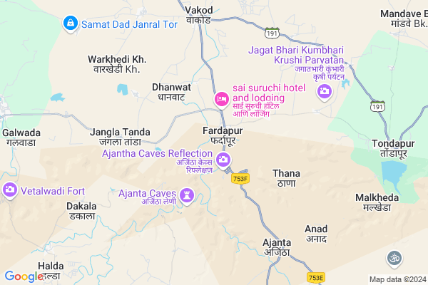
Fardapur is a Village in Soegaon Taluka in Aurangabad District District of Maharashtra State, India. It belongs to Marathwada region . It belongs to Aurangabad Division . It is located 102 KM towards North from District head quarters Aurangabad. 18 KM from Soegaon. 405 KM from State capital Mumbai
Fardapur Pin code is 431118 and postal head office is Phardapur .
Warkhedi ( 2 KM ) , Warkhedi Bk. ( 2 KM ) , Sawarkheda ( 4 KM ) , Ajantha ( 7 KM ) , Anad ( 7 KM ) are the nearby Villages to Fardapur. Fardapur is surrounded by Jamner Taluka towards North , Sillod Taluka towards South , Pachora Taluka towards west , Bhokardan Taluka towards South .
Soyagaon , Sillod , Pachora , Malkapur are the near by Cities to Fardapur.
Fardapur 2011 Census Details
Fardapur Local Language is Hindi. Fardapur Village Total population is 9167 and number of houses are 1742. Female Population is 48.3%. Village literacy rate is 62.4% and the Female Literacy rate is 25.6%.
Population
| Census Parameter | Census Data |
| Total Population | 9167 |
| Total No of Houses | 1742 |
| Female Population % | 48.3 % ( 4427) |
| Total Literacy rate % | 62.4 % ( 5719) |
| Female Literacy rate | 25.6 % ( 2348) |
| Scheduled Tribes Population % | 7.7 % ( 707) |
| Scheduled Caste Population % | 10.1 % ( 929) |
| Working Population % | 42.6 % |
| Child(0 -6) Population by 2011 | 1375 |
| Girl Child(0 -6) Population % by 2011 | 47.3 % ( 651) |
Fardapur Census More Deatils.
Politics in Fardapur
Bharatiya Janata Party , BJP , INC , SHS are the major political parties in this area.Polling Stations /Booths near Fardapur
1)Dongargaon2)Fardapur
3)Fardapur
4)Fardapur
5)Fardapur
HOW TO REACH Fardapur
By Rail
There is no railway station near to Fardapur in less than 10 km. Jalgaon Junction Rail Way Station (near to Jalgaon) , Pachora Junction Rail Way Station (near to Pachora) , Galan Rail Way Station (near to Pachora) are the Rail way stations reachable from near by towns.By Road
Pachora , Jalgaon are the nearby by towns to Fardapur having road connectivity to FardapurColleges near Fardapur
Seniar Arts College GondegaonSchools in Fardapur
Manikrao Palod Vidhlaya FarGovt Health Centers near Fardapur
1) Tondapur , At Tondapur , Tal Jamner , Near Mandir2) Adgaon , Sub Center Adgaon , At Post Adgaon ,
3) Dhawada , Primary Health Center Dhawada , At Post Dhawada , PHC Dhawada
Hospitals in Fardapur,Soegaon
Pitruchaaya Hospital PCH
PCH Marigold Premises; Marigold complex; Kalyani Nagar; Pune; Maharashtra 411014; India
12.4 KM distance Detail
more ..
Petrol Bunks in Fardapur,Soegaon
HP PETROL PUMP - OM SAI PETROLEUM
Post:-soyegaon Tq:-soyegaon; Maharashtra 432011; India
11.8 KM distance Detail
Sant Gadage Maharaj Chaik
Soygaon - Fardapur Rd; Soygaon; Maharashtra 431120; India
11.9 KM distance Detail
more ..
Colleges in Fardapur,Soegaon
Patil Krushi seva Kendra
Post Office Soegaon; Soygaon; Maharashtra 431120; India
12.4 KM distance Detail
Sant Dnyaneshwar Mahavidyalaya
Soegaon Taluk; Soegaon Dist; Maharashtra 431120; India
12.6 KM distance Detail
more ..
Local Parks in Fardapur,Soegaon
Jay Bhavani Jay Shivaji Mitra Mandal
Soygaon - Fardapur Rd; Amkheda; Maharashtra 431120; India
13.0 KM distance Detail
Police Stations near Fardapur,Soegaon
Governement Offices near Fardapur,Soegaon
How to reach Fardapur
Tourist Places Near By Fardapur
Schools in Fardapur
Colleges in Fardapur
Temperature & weather of Fardapur
places in Fardapur
Fardapur photos
More Information
Village Talk
Post News or Events about this Village
Soyagaon 12 KM near
Sillod 33 KM near
Pachora 44 KM near
Malkapur 46 KM near
Soegaon 17 KM near
Jamner 22 KM near
Sillod 26 KM near
Pachora 38 KM near
Chikkalthana Airport 96 KM near
Gandhinagar Airport 235 KM near
Nanded Airport 255 KM near
Indore Airport 267 KM near
Burhanpur 78 KM near
Grishneshwar 94 KM near
Aurangabad 98 KM near
Dhule 117 KM near
Washim 176 KM near
Buldhana 54 KM near
Jalgaon 55 KM near
Jalna 92 KM near
Aurangabad District 97 KM near
Pachora Junction Rail Way Station 44 KM near
Bodwad Rail Way Station 53 KM near