| Home | City Bus | Maps | Villages | Cities | Rail | Tourist Places | School | College | Pin Codes | Corona Cases Count |
| Distance Calculator Bus Services IFSC Codes Trace Mobile Number Weather Search Place Trace IP Available Cash ATM/Banks Locate Polling Booth Report an Error contact People |
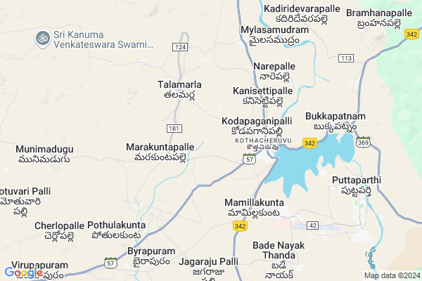
Narepalli
Narepalli Map
EDIT Map
Add Your House
 ..
..
Current Corona Virus Infected Patients Count in Anantapur District
| City Name | District Name | Total Covid cases |
|---|---|---|
| Anantapur District | Anantapur | 36 |
| Anantapur | Anantapur | 5 |
| Hindupur | Anantapur | 3 |
| R K Function Hall Backside | Anantapur | 2 |
| Lepakshi | Anantapur | 2 |
| Kalyana Durgam | Anantapur | 1 |
| Hindupur Mandal | Anantapur | 1 |
| Naik Nagar | Anantapur | 1 |
| Kothacheruvu | Anantapur | 1 |
| Aravinda Nagar | Anantapur | 1 |
Locality Name :
Narepalli
( మారేపల్లి )
Mandal Name : Kothacheruvu
District : Anantapur
State : Andhra Pradesh
Region : Rayalaseema
Language : Telugu and Urdu
Current Time 12:30 PM
Date: Friday , Mar 14,2025 (IST)
Time zone: IST (UTC+5:30)
Elevation / Altitude: 444 meters. Above Seal level
Telephone Code / Std Code: 08557
Assembly constituency : assembly constituency
Assembly MLA : DUDDUKUNTA SREEDHAR REDDY
Lok Sabha constituency : parliamentary constituency
Parliament MP : KURUVA GORANTLA MADHAV
Serpanch Name :
Pin Code : 515144
Post Office Name : Bukkapatnam
Alternate Village Name : Narepalle
Commodities Prices : Gowribidanoor Market / Mandi
National Highways Reachable To Narepalli
Nationa High Way :NH342
Nationa High Way :NH42
Nationa High Way :NH342
Nationa High Way :NH42
Rivers Near Narepalli
Chitravati :ಚಿತ್ರಾವತಿ :చిత్రావతి
Madduleru River
Chitravati :ಚಿತ್ರಾವತಿ :చిత్రావతి
Madduleru River
About Narepalli
Correct below Info and add more info about NarepalliNarepalli is a Village in Kothacheruvu Mandal in Anantapur District of Andhra Pradesh State, India. It belongs to Rayalaseema region . It is located 66 KM towards South from District head quarters Anantapur. 425 KM from State capital Hyderabad
Narepalli Pin code is 515144 and postal head office is Bukkapatnam .
Narepalli is surrounded by Puttaparthi Mandal towards South , Chennekothapalle Mandal towards North , Penukonda Mandal towards west , Bukkapatnam Mandal towards East .
Dharmavaram , Kadiri , Hindupur , Pavagada are the near by Cities to Narepalli.
Narepalle 2011 Census Details
Narepalli Local Language is Telugu. Narepalle Village Total population is 787 and number of houses are 215. Female Population is 48.7%. Village literacy rate is 53.1% and the Female Literacy rate is 20.3%.
Population
| Census Parameter | Census Data |
| Total Population | 787 |
| Total No of Houses | 215 |
| Female Population % | 48.7 % ( 383) |
| Total Literacy rate % | 53.1 % ( 418) |
| Female Literacy rate | 20.3 % ( 160) |
| Scheduled Tribes Population % | 0.0 % ( 0) |
| Scheduled Caste Population % | 10.4 % ( 82) |
| Working Population % | 58.1 % |
| Child(0 -6) Population by 2011 | 84 |
| Girl Child(0 -6) Population % by 2011 | 47.6 % ( 40) |
Narepalle Census More Deatils.
HOW TO REACH Narepalli
By Road
Dharmavaram is the Nearest Town to Narepalli. Dharmavaram is 25 km from Narepalli. Road connectivity is there from Dharmavaram to Narepalli.By Rail
Kotha Cheruvu Rail Way Station , Sri Sathya Sai Prashanthi Nilayam Rail Way Station are the very nearby railway stations to Narepalli. Also you can consider railway Stations from Near By town Dharmavaram. Dharmavaram Junction Rail Way Station are the railway Stations near to Dharmavaram. You can reach from Dharmavaram to Narepalli by road after .By Bus
Kothacheruvu APSRTC Bus Station , K.Cheru APSRTC Bus Station , Ptp Super Hospital APSRTC Bus Station are the nearby by Bus Stations to Narepalli .APSRTC runs Number of busses from major cities to here.Colleges near Narepalli
Govt Junior College Kothacheruvu
Address : Govt Junior College Kothacheruvu
Sai Teja Jr College, Kothacheruvu
Address : Kothacheruvu
Sri Siva Sai Degree College
Address : Mylipalli, Kodapaganipalli (po), Kothacheruvu-515
Schools in Narepalli
Mpups Narepalli
Address : narepalle , kothacheruvu , anantapur , Andhra Pradesh . PIN- 515144 , Post - Bukkapatnam
Govt Health Centers near Narepalli
1) Sc Meejapuram , PANCHAYAT BUILDING 12 , BC PALLI ROAD , MEERJAPURAM2) Sc Mylasamudram , 1c-151 , panchayat office back , near ramulavari temple
3) Bukkapatnam , 4-358 , PHC Compound , Near Bus Stand
Schools in Narepalli,Kothacheruvu
M P U P SCHOOL ;C C KOTHAKOTA
Pothulanagepalle; Andhra Pradesh 515651; India
18.9 KM distance Detail
Electronic Shops in Narepalli,Kothacheruvu
Super Markets in Narepalli,Kothacheruvu
Police Stations near Narepalli,Kothacheruvu
Governement Offices near Narepalli,Kothacheruvu
MeeSeva Center
P.Ramesh Online Center; Medapuram; Andhra Pradesh 515651; India
19.3 KM distance Detail
About Narepalli &
History
How to reach Narepalli
Tourist Places Near By Narepalli
Schools in Narepalli
Colleges in Narepalli
Temperature & weather of Narepalli
places in Narepalli
Narepalli photos
More Information
How to reach Narepalli
Tourist Places Near By Narepalli
Schools in Narepalli
Colleges in Narepalli
Temperature & weather of Narepalli
places in Narepalli
Narepalli photos
More Information
Village Talk
Post News or Events about this Village
Near Cities
Dharmavaram 27 KM near
Kadiri 51 KM near
Hindupur 53 KM near
Pavagada 53 KM near
Dharmavaram 27 KM near
Kadiri 51 KM near
Hindupur 53 KM near
Pavagada 53 KM near
Near By Taluks
Kothacheruvu 0 KM near
Puttaparthi 9 KM near
Chennekothapalle 13 KM near
Penukonda 20 KM near
Kothacheruvu 0 KM near
Puttaparthi 9 KM near
Chennekothapalle 13 KM near
Penukonda 20 KM near
Near By Air Ports
Bengaluru International Airport 123 KM near
Tirupati Airport 228 KM near
Mysore Airport 269 KM near
Salem Airport 320 KM near
Bengaluru International Airport 123 KM near
Tirupati Airport 228 KM near
Mysore Airport 269 KM near
Salem Airport 320 KM near
Near By Tourist Places
Puttaparthi 6 KM near
Lepakshi 50 KM near
Nandi Hills 102 KM near
Horsley Hills 103 KM near
Kadapa 135 KM near
Puttaparthi 6 KM near
Lepakshi 50 KM near
Nandi Hills 102 KM near
Horsley Hills 103 KM near
Kadapa 135 KM near
Near By Districts
Anantapur 63 KM near
Chikballapur 95 KM near
Bangalore Rural 117 KM near
Tumkur 131 KM near
Anantapur 63 KM near
Chikballapur 95 KM near
Bangalore Rural 117 KM near
Tumkur 131 KM near
Near By RailWay Station
Kotha Cheruvu Rail Way Station 2.6 KM near
Sri Sathya Sai Prashanthi Nilayam Rail Way Station 4.5 KM near
Penukonda Junction Rail Way Station 20 KM near
Kotha Cheruvu Rail Way Station 2.6 KM near
Sri Sathya Sai Prashanthi Nilayam Rail Way Station 4.5 KM near
Penukonda Junction Rail Way Station 20 KM near