| Home | City Bus | Maps | Villages | Cities | Rail | Tourist Places | School | College | Pin Codes | Corona Cases Count |
| Distance Calculator Bus Services IFSC Codes Trace Mobile Number Weather Search Place Trace IP Available Cash ATM/Banks Locate Polling Booth Report an Error contact People |
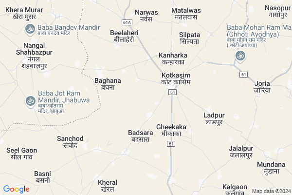
Kasimpur Map
EDIT Map
Add Your House
 ..
..
Current Corona Virus Infected Patients Count in Alwar District
| City Name | District Name | Total Covid cases |
|---|---|---|
| Alwar District | Alwar | 7 |
Locality Name :
Kasimpur
( कासिमपुर )
Tehsil Name : Kotkasim
District : Alwar
State : Rajasthan
Division : Jaipur
Language : Rajasthani
Current Time 10:13 AM
Date: Wednesday , Apr 30,2025 (IST)
Time zone: IST (UTC+5:30)
Elevation / Altitude: 273 meters. Above Seal level
Telephone Code / Std Code: 01493
Assembly constituency : Kishangarh Bas assembly constituency
Assembly MLA : Deepchand Khairiya
Lok Sabha constituency : Alwar parliamentary constituency
Parliament MP : Balak Nath
Serpanch Name :
Pin Code : 301702
Post Office Name : Kotkassim
Main Village Name : Kasimpur
Commodities Prices : Rewari Market / Mandi
Kasimpur Live Weather
Temperature: 32.8 °C
clear sky
Humidity: 29%
Wind : 4.85 mt/sec towards SE
StationName : "BakÄ\u0081pur"
observed on 22 Mins Back
Temperature: 32.8 °C
clear sky
Humidity: 29%
Wind : 4.85 mt/sec towards SE
StationName : "BakÄ\u0081pur"
observed on 22 Mins Back
Kasimpur Weather Forecast for Next 5 days
01-05-2025
30.5°C to 38.8°C
clear sky
30.5°C to 38.8°C
clear sky
02-05-2025
29.0°C to 42.8°C
clear sky, light rain, broken clouds, scattered clouds
29.0°C to 42.8°C
clear sky, light rain, broken clouds, scattered clouds
03-05-2025
29.0°C to 42.5°C
scattered clouds, broken clouds, clear sky, light rain
29.0°C to 42.5°C
scattered clouds, broken clouds, clear sky, light rain
04-05-2025
28.8°C to 41.2°C
light rain, broken clouds, scattered clouds
28.8°C to 41.2°C
light rain, broken clouds, scattered clouds
05-05-2025
26.4°C to 40.7°C
broken clouds, scattered clouds
26.4°C to 40.7°C
broken clouds, scattered clouds
National Highways Reachable To Kasimpur
Nationa High Way :NH48
Nationa High Way :NH148B
Nationa High Way :NH48
Nationa High Way :NH148B
Rivers Near Kasimpur
Chalak Nala
Sota
Chalak Nala
Sota
About Kasimpur
Correct below Info and add more info about KasimpurKasimpur is a small Village/hamlet in Kotkasim Tehsil in Alwar District of Rajasthan State, India. It comes under Kasimpur Panchayath. It belongs to Jaipur Division . It is located 60 KM towards North from District head quarters Alwar. 5 KM from Kotkasim. 176 KM from State capital Jaipur
Kasimpur Pin code is 301702 and postal head office is Kotkassim .
Kanharka ( 3 KM ) , Gheekaka ( 4 KM ) , Bilaheri ( 4 KM ) , Khanpur Aheer ( 5 KM ) , Ladpur ( 6 KM ) are the nearby Villages to Kasimpur. Kasimpur is surrounded by Bawal Tehsil towards west , Tijara Tehsil towards East , Rewari Tehsil towards North , Mandawar Tehsil towards west .
Bawal , Rewari , Sohna , Narnaul are the near by Cities to Kasimpur.
This Place is in the border of the Alwar District and Rewari District. Rewari District Bawal is west towards this place . It is near to the Haryana State Border.
Kasimpur 2011 Census Details
Kasimpur Local Language is Rajasthani. Kasimpur Village Total population is 547 and number of houses are 65. Female Population is 43.1%. Village literacy rate is 66.5% and the Female Literacy rate is 23.8%.
Population
| Census Parameter | Census Data |
| Total Population | 547 |
| Total No of Houses | 65 |
| Female Population % | 43.1 % ( 236) |
| Total Literacy rate % | 66.5 % ( 364) |
| Female Literacy rate | 23.8 % ( 130) |
| Scheduled Tribes Population % | 0.0 % ( 0) |
| Scheduled Caste Population % | 0.0 % ( 0) |
| Working Population % | 56.9 % |
| Child(0 -6) Population by 2011 | 46 |
| Girl Child(0 -6) Population % by 2011 | 34.8 % ( 16) |
Kasimpur Census More Deatils.
Politics in Kasimpur
Bharatiya Janata Party , BJP , BSP , INC are the major political parties in this area.Polling Stations /Booths near Kasimpur
1)Govt. Primary School Viranwas2)Govt. Senior Secondary School Kotkasim East Part
3)Govt. Upper Primary School Husaipur
4)Govt. Sanskrit Collage Kotkasim
5)Govt. Senior Secondary School Joria North Side
HOW TO REACH Kasimpur
By Rail
There is no railway station near to Kasimpur in less than 10 km.Colleges near Kasimpur
Bhagat Singh Mahila College Kotkasim
Address :
Govt Bibirani College, Bibirani, Kotkasim
Address :
Rao Prakash Private Iti College
Address : Patan Ahir,harsoli Road Near Kadiya , Alwar(raj.)
Sharama Morden B.ed Collage
Address : Harsoli Road,patan Aheer
Govt. Sanskrit Coollege
Address : Near Ramleela Ground
Schools in Kasimpur
Govt. Ps Kasimpur
Address : kasimpur , kotkasim , alwar , Rajasthan . PIN- 301702 , Post - Kotkassim
Govt Health Centers near Kasimpur
1) Baghana , PHC BAGHANA , baghana , kotkasim2) Kotkasim , CHC KOTKASIM , SDM COURT KE PASS , rajasthan
3) Kanhadka , kanhadka , kotkasim , kotkasim
Sub Villages in Kasimpur
Hospitals in Kasimpur,Kotkasim
BIMLA DIAGNOSTIC CENTRE
High School Road; Major District Road; 61A; Kumharwara Mohalla; Kotkasim; Rajasthan 301702; India
2.3 KM distance Detail
Near Govt Hospital Kotkasim Alwar
High School Road; Major District Road; 61A; Kumharwara Mohalla; Kotkasim; Rajasthan 301702; India
2.3 KM distance Detail
Dr Manoj Chauhan clinic(Pediatrician)
Kumharwara Mohalla; Kotkasim; Rajasthan 301702; India
2.4 KM distance Detail
more ..
Colleges in Kasimpur,Kotkasim
Yashika Medical Store
OPP-GOVT.CHC; Kumharwara Mohalla; Kotkasim; Rajasthan 301702; India
2.3 KM distance Detail
more ..
Schools in Kasimpur,Kotkasim
Govt Sen Sec School Kotkasim
Kanugoyan Mohalla; Kotkasim; Rajasthan 301702; India
2.1 KM distance Detail
goverment School
Hign School Road; MDR61A Kumharwara Mohalla; MDR61A; Kumharwara Mohalla; Kotkasim; Rajasthan 301702; India
2.2 KM distance Detail
Electronic Shops in Kasimpur,Kotkasim
Gupta Hardware Store
Hign School Road; MDR61A; Kumharwara Mohalla; MDR61A; Kumharwara Mohalla; Kotkasim; Rajasthan 301702; India
2.2 KM distance Detail
Suraj T.V. Repairing Store
Kumharwara Mohalla; Kotkasim; Rajasthan 301702; India
2.4 KM distance Detail
Super Markets in Kasimpur,Kotkasim
Vijay Agarwal Bsnl Distributer
Kanugoyan Mohalla; Kotkasim; Rajasthan 301702; India
2.0 KM distance Detail
Surendra Agarwal Ultratech Ciment
Hign School Road; Major District Road 61A; Kumharwara Mohalla; Kotkasim; Rajasthan 301702; India
2.4 KM distance Detail
Manoj Agarwal Lays;Pepsi;Kurkure & More Brand Distributer
Hign School Road; MDR61A; Kumharwara Mohalla; Kotkasim; Rajasthan 301702; India
2.5 KM distance Detail
Governement Offices near Kasimpur,Kotkasim
saini e-mitra
New Market Rd; Kumharwara Mohalla; Teacher Colony; Tapukara; Rajasthan 301707; India
2.2 KM distance Detail
About Kasimpur &
History
How to reach Kasimpur
Tourist Places Near By Kasimpur
Schools in Kasimpur
Colleges in Kasimpur
Temperature & weather of Kasimpur
places in Kasimpur
Kasimpur photos
More Information
How to reach Kasimpur
Tourist Places Near By Kasimpur
Schools in Kasimpur
Colleges in Kasimpur
Temperature & weather of Kasimpur
places in Kasimpur
Kasimpur photos
More Information
Village Talk
Post News or Events about this Village
Near Cities
Bawal 15 KM near
Rewari 23 KM near
Sohna 49 KM near
Narnaul 56 KM near
Bawal 15 KM near
Rewari 23 KM near
Sohna 49 KM near
Narnaul 56 KM near
Near By Taluks
Kotkasim 4 KM near
Bawal 15 KM near
Tijara 16 KM near
Rewari 23 KM near
Kotkasim 4 KM near
Bawal 15 KM near
Tijara 16 KM near
Rewari 23 KM near
Near By Air Ports
Indira Gandhi International Airport 79 KM near
Kheria Airport 175 KM near
Sanganeer Airport 179 KM near
Muzaffarnagar Airport 205 KM near
Indira Gandhi International Airport 79 KM near
Kheria Airport 175 KM near
Sanganeer Airport 179 KM near
Muzaffarnagar Airport 205 KM near
Near By Tourist Places
Nuh 35 KM near
Manesar 49 KM near
Sohna 49 KM near
Alwar 57 KM near
Narnaul 64 KM near
Nuh 35 KM near
Manesar 49 KM near
Sohna 49 KM near
Alwar 57 KM near
Narnaul 64 KM near
Near By Districts
Rewari 24 KM near
Mewat 34 KM near
Alwar 56 KM near
Mahendragarh 65 KM near
Rewari 24 KM near
Mewat 34 KM near
Alwar 56 KM near
Mahendragarh 65 KM near
Near By RailWay Station
Rewari Junction Rail Way Station 24 KM near
Khairthal Rail Way Station 28 KM near
Rewari Junction Rail Way Station 24 KM near
Khairthal Rail Way Station 28 KM near