| Home | City Bus | Maps | Villages | Cities | Rail | Tourist Places | School | College | Pin Codes | Corona Cases Count |
| Distance Calculator Bus Services IFSC Codes Trace Mobile Number Weather Search Place Trace IP Available Cash ATM/Banks Locate Polling Booth Report an Error contact People |
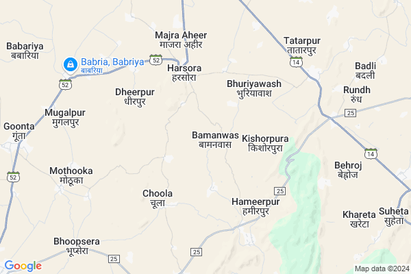
Bamanwas Map
EDIT Map
Add Your House
 ..
..
Current Corona Virus Infected Patients Count in Alwar District
| City Name | District Name | Total Covid cases |
|---|---|---|
| Alwar District | Alwar | 7 |
Locality Name :
Bamanwas
( बामनवास )
Tehsil Name : Bansur
District : Alwar
State : Rajasthan
Division : Jaipur
Language : Rajasthani
Current Time 11:44 AM
Date: Sunday , Apr 27,2025 (IST)
Time zone: IST (UTC+5:30)
Elevation / Altitude: 289 meters. Above Seal level
Telephone Code / Std Code: 01461
Assembly constituency : Bansur assembly constituency
Assembly MLA : Devi Singh Shekhawat
Lok Sabha constituency : Jaipur Rural parliamentary constituency
Parliament MP : COL. RAJYAVARDHAN RATHORE
Serpanch Name :
Pin Code : 301412
Post Office Name : Harsora
Commodities Prices : Khairthal Market / Mandi
National Highways Reachable To Bamanwas
Nationa High Way :NH148B
Nationa High Way :NH48
Nationa High Way :NH148B
Nationa High Way :NH48
Rivers Near Bamanwas
Sahibi
Sota
Sahibi
Sota
About Bamanwas
Correct below Info and add more info about BamanwasBamanwas is a Village in Bansur Tehsil in Alwar District of Rajasthan State, India. It belongs to Jaipur Division . It is located 28 KM towards North from District head quarters Alwar. 15 KM from Bansur. 131 KM from State capital Jaipur
Bamanwas Pin code is 301412 and postal head office is Harsora .
Hameerpur ( 5 KM ) , Deosan ( 8 KM ) , Hajipur ( 8 KM ) , Mothooka ( 8 KM ) , Babriya ( 9 KM ) are the nearby Villages to Bamanwas. Bamanwas is surrounded by Mandawar Tehsil towards North , Alwar Tehsil towards South , Kishangarh Bas Tehsil towards East , Behror Tehsil towards North .
Alwar , Bawal , Narnaul , Neem-Ka-Thana are the near by Cities to Bamanwas.
This Place is in the border of the Alwar District and Jaipur District. Jaipur District Kotputli is west towards this place .
Bamanwas 2011 Census Details
Bamanwas Local Language is Rajasthani. Bamanwas Village Total population is 1279 and number of houses are 224. Female Population is 47.4%. Village literacy rate is 61.8% and the Female Literacy rate is 24.8%.
Population
| Census Parameter | Census Data |
| Total Population | 1279 |
| Total No of Houses | 224 |
| Female Population % | 47.4 % ( 606) |
| Total Literacy rate % | 61.8 % ( 791) |
| Female Literacy rate | 24.8 % ( 317) |
| Scheduled Tribes Population % | 0.0 % ( 0) |
| Scheduled Caste Population % | 10.6 % ( 135) |
| Working Population % | 65.6 % |
| Child(0 -6) Population by 2011 | 156 |
| Girl Child(0 -6) Population % by 2011 | 41.0 % ( 64) |
Bamanwas Census More Deatils.
Politics in Bamanwas
INC , BJP , BJP , INC are the major political parties in this area.Polling Stations /Booths near Bamanwas
1)Govt.upper Primary School Guwada2)Govt.secondary School Buteri East Part Room No. 2
3)Govt. Senior Secondary School Hamirpur South Part Room No. 6
4)Govt. Secondary School East Part Garhi
5)Govt.secondary School Choola South Part
HOW TO REACH Bamanwas
By Rail
There is no railway station near to Bamanwas in less than 10 km.Colleges near Bamanwas
Kota College Of Pharmacy
Address : Kota College Of Pharmacy Sp 1, Riico Industrial Ar
Schools in Bamanwas
Shree Shyam Ps Bamanwas
Address : bamanwas , bansur , alwar , Rajasthan . PIN- 301402 , Post - Bansur
Govt. Ss Bamanwas
Address : bamanwas , bansur , alwar , Rajasthan . PIN- 301402 , Post - Bansur
Govt Health Centers near Bamanwas
1) Beroj , , ,2) Khareta , khareta , khareta ,
3) Shamda , , ,
Hospitals in Bamanwas,Bansur
Government Primary Health Center
Harsaura; Alwar; SH-52; Alwar Road; Alwar; Alwar; Rajasthan 301701; India
4.2 KM distance Detail
more ..
Petrol Bunks in Bamanwas,Bansur
Abhilash Petrol Pump
Harsaura; Alwar; SH-52; Alwar Road; Alwar; Alwar; Rajasthan 301412; India
4.9 KM distance Detail
more ..
Colleges in Bamanwas,Bansur
Bhartiya Vidya Mandir Teachers' Training College
Dialab Road; Opposite Mahi Guest House; Banswara; Rajasthan 327001; India
11.6 KM distance Detail
more ..
Schools in Bamanwas,Bansur
Government High School
Harsaura; Alwar; SH-52; Alwar Road; Alwar; Alwar; Rajasthan 301701; India
4.2 KM distance Detail
Electronic Shops in Bamanwas,Bansur
Jai Durge Dj Bansur
Harsora Bypass Near Durga Marrige Garden; Bansur; Rajasthan 301402; India
4.2 KM distance Detail
Police Stations near Bamanwas,Bansur
Soni Hero Honda Service Center
RJ SH 52; Majra Aheer; Rajasthan 301412; India
4.6 KM distance Detail
About Bamanwas &
History
How to reach Bamanwas
Tourist Places Near By Bamanwas
Schools in Bamanwas
Colleges in Bamanwas
Temperature & weather of Bamanwas
places in Bamanwas
Bamanwas photos
More Information
How to reach Bamanwas
Tourist Places Near By Bamanwas
Schools in Bamanwas
Colleges in Bamanwas
Temperature & weather of Bamanwas
places in Bamanwas
Bamanwas photos
More Information
Village Talk
Post News or Events about this Village
Near Cities
Alwar 28 KM near
Bawal 43 KM near
Narnaul 44 KM near
Neem-Ka-Thana 53 KM near
Alwar 28 KM near
Bawal 43 KM near
Narnaul 44 KM near
Neem-Ka-Thana 53 KM near
Near By Taluks
Bansur 14 KM near
Mandawar 19 KM near
Behror 29 KM near
Alwar 29 KM near
Bansur 14 KM near
Mandawar 19 KM near
Behror 29 KM near
Alwar 29 KM near
Near By Air Ports
Indira Gandhi International Airport 122 KM near
Sanganeer Airport 136 KM near
Kheria Airport 181 KM near
Muzaffarnagar Airport 247 KM near
Indira Gandhi International Airport 122 KM near
Sanganeer Airport 136 KM near
Kheria Airport 181 KM near
Muzaffarnagar Airport 247 KM near
Near By Tourist Places
Alwar 28 KM near
Sariska 45 KM near
Narnaul 52 KM near
Nuh 74 KM near
Sohna 91 KM near
Alwar 28 KM near
Sariska 45 KM near
Narnaul 52 KM near
Nuh 74 KM near
Sohna 91 KM near
Near By Districts
Alwar 27 KM near
Mahendragarh 53 KM near
Rewari 58 KM near
Mewat 74 KM near
Alwar 27 KM near
Mahendragarh 53 KM near
Rewari 58 KM near
Mewat 74 KM near
Near By RailWay Station
Khairthal Rail Way Station 20 KM near
Alwar Junction Rail Way Station 29 KM near
Khairthal Rail Way Station 20 KM near
Alwar Junction Rail Way Station 29 KM near