| Home | City Bus | Maps | Villages | Cities | Rail | Tourist Places | School | College | Pin Codes | Corona Cases Count |
| Distance Calculator Bus Services IFSC Codes Trace Mobile Number Weather Search Place Trace IP Available Cash ATM/Banks Locate Polling Booth Report an Error contact People |
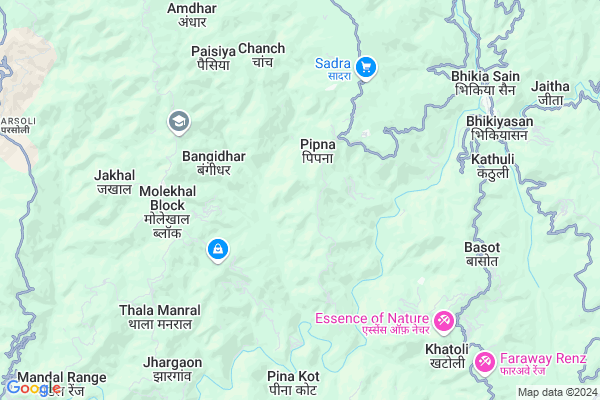
Puna Kot
Puna Kot Map
EDIT Map
Add Your House
 ..
..
Current Corona Virus Infected Patients Count in Almora District
| City Name | District Name | Total Covid cases |
|---|---|---|
| Almora District | Almora | 1 |
Locality Name :
Puna Kot
( पौंआ कोट )
Block Name : Sult
District : Almora
State : Uttarakhand
Language : Hindi and Urdu
Current Time 11:06 AM
Date: Friday , Mar 14,2025 (IST)
Time zone: IST (UTC+5:30)
Elevation / Altitude: 345 meters. Above Seal level
Telephone Code / Std Code: 05966
Assembly constituency : Salt assembly constituency
Assembly MLA : Mahesh Jeena
Lok Sabha constituency : Almora parliamentary constituency
Parliament MP : Ajay Tamta
Serpanch Name :
Pin Code : 263676
Post Office Name : Maulekhal
Alternate Village Name : Punakote
Commodities Prices : Ramnagar Market / Mandi
Puna Kot Live Weather
Temperature: 20.9 °C
clear sky
Humidity: 26%
Wind : 0.74 mt/sec towards SE
StationName : "RÄ\u0081nikhet"
observed on 41 Mins Back
Temperature: 20.9 °C
clear sky
Humidity: 26%
Wind : 0.74 mt/sec towards SE
StationName : "RÄ\u0081nikhet"
observed on 41 Mins Back
Puna Kot Weather Forecast for Next 5 days
15-03-2025
15.0°C to 26.6°C
clear sky, broken clouds, light rain
15.0°C to 26.6°C
clear sky, broken clouds, light rain
16-03-2025
11.8°C to 27.0°C
light rain, scattered clouds, broken clouds, overcast clouds
11.8°C to 27.0°C
light rain, scattered clouds, broken clouds, overcast clouds
17-03-2025
12.6°C to 23.8°C
light rain, overcast clouds, scattered clouds, few clouds
12.6°C to 23.8°C
light rain, overcast clouds, scattered clouds, few clouds
18-03-2025
12.8°C to 26.1°C
scattered clouds, clear sky, few clouds
12.8°C to 26.1°C
scattered clouds, clear sky, few clouds
19-03-2025
12.6°C to 27.3°C
clear sky, few clouds, scattered clouds, overcast clouds
12.6°C to 27.3°C
clear sky, few clouds, scattered clouds, overcast clouds
National Highways Reachable To Puna Kot
Nationa High Way :NH309A
Nationa High Way :NH309A
Rivers Near Puna Kot
Kosi River
Kosi River
Kosi River
Kosi River
About Puna Kot
Correct below Info and add more info about Puna KotPuna Kot is a Village in Sult Block in Almora District of Uttarakhand State, India. It is located 52 KM towards west from District head quarters Almora. 156 KM from State capital Dehradun
Puna Kot Pin code is 263676 and postal head office is Maulekhal .
Puna Kot is surrounded by Bhikiyasain Block towards East , Nainidanda Block towards west , Syaldey Block towards North , Tarikhet Block towards East .
Ramnagar , Nainital , Almora , Bazpur are the near by Cities to Puna Kot.
Punakote 2011 Census Details
Puna Kot Local Language is Hindi. Punakote Village Total population is 430 and number of houses are 95. Female Population is 55.6%. Village literacy rate is 65.8% and the Female Literacy rate is 32.3%.
Population
| Census Parameter | Census Data |
| Total Population | 430 |
| Total No of Houses | 95 |
| Female Population % | 55.6 % ( 239) |
| Total Literacy rate % | 65.8 % ( 283) |
| Female Literacy rate | 32.3 % ( 139) |
| Scheduled Tribes Population % | 0.0 % ( 0) |
| Scheduled Caste Population % | 0.0 % ( 0) |
| Working Population % | 88.6 % |
| Child(0 -6) Population by 2011 | 57 |
| Girl Child(0 -6) Population % by 2011 | 38.6 % ( 22) |
Punakote Census More Deatils.
Politics in Puna Kot
BJP , BJP , INC are the major political parties in this area.Polling Stations /Booths near Puna Kot
1)Bhyarhi2)Taya Bhandarkhola
3)Peepana
4)Udaipur
5)Jheepa
HOW TO REACH Puna Kot
By Rail
There is no railway station near to Puna Kot in less than 10 km.Colleges near Puna Kot
Govt. Inter College Manila
Address :
P G College Manila
Address :
Government Inter College, Jhar Goan, P.o. Marchula, Sult
Address : -
Schools near Puna Kot
G.h.s.s Bheetakotkhal
Address : bheetakot , salt , almora , Uttarakhand . PIN- 263676 , Post - Maulekhal
G.i.c. Jhimar
Address : dungra , salt , almora , Uttarakhand . PIN- 263667 , Post - Bhikiyasen
G.i.c. Khumar
Address : kuloli , salt , almora , Uttarakhand . PIN- 263676 , Post - Maulekhal
G.i.c. Soli
Address : soli , salt , almora , Uttarakhand . PIN- 263676 , Post - Maulekhal
Govt Health Centers near Puna Kot
1) Golikhal SC , , Golikhal , Golikhal2) Health Sub Center Mehalchauri , SC Mehalchauri , ,
3) Health Sub Center Rohida , SC Rohida , ,
Super Markets in Puna Kot,Sult
Local Parks in Puna Kot,Sult
eco park binsar sauni(ranikhet uttrakhand)camping Site
Chamadkhan - Titalikhet - Binsar - Sauni Rd; Ranikhet Range; Uttarakhand 263664; India
16.8 KM distance Detail
Governement Offices near Puna Kot,Sult
About Puna Kot &
History
How to reach Puna Kot
Tourist Places Near By Puna Kot
Schools in Puna Kot
Colleges in Puna Kot
Temperature & weather of Puna Kot
places in Puna Kot
Puna Kot photos
More Information
How to reach Puna Kot
Tourist Places Near By Puna Kot
Schools in Puna Kot
Colleges in Puna Kot
Temperature & weather of Puna Kot
places in Puna Kot
Puna Kot photos
More Information
Village Talk
Post News or Events about this Village
Near Cities
Ramnagar 35 KM near
Nainital 46 KM near
Almora 49 KM near
Bazpur 62 KM near
Ramnagar 35 KM near
Nainital 46 KM near
Almora 49 KM near
Bazpur 62 KM near
Near By Taluks
Sult 0 KM near
Bhikiyasain 11 KM near
Nainidanda 16 KM near
Syaldey 22 KM near
Sult 0 KM near
Bhikiyasain 11 KM near
Nainidanda 16 KM near
Syaldey 22 KM near
Near By Air Ports
Pantnagar Airport 84 KM near
Dehra Dun Airport 149 KM near
Muzaffarnagar Airport 168 KM near
Indira Gandhi International Airport 267 KM near
Pantnagar Airport 84 KM near
Dehra Dun Airport 149 KM near
Muzaffarnagar Airport 168 KM near
Indira Gandhi International Airport 267 KM near
Near By Tourist Places
Ranikhet 25 KM near
Dwarahat 28 KM near
Corbett National Park 33 KM near
Ramnagar 34 KM near
Jageshwar 41 KM near
Ranikhet 25 KM near
Dwarahat 28 KM near
Corbett National Park 33 KM near
Ramnagar 34 KM near
Jageshwar 41 KM near
Near By Districts
Nainital 46 KM near
Almora 50 KM near
Bageshwar 65 KM near
Pauri Garhwal 75 KM near
Nainital 46 KM near
Almora 50 KM near
Bageshwar 65 KM near
Pauri Garhwal 75 KM near
Near By RailWay Station
Ramnagar Rail Way Station 35 KM near
Kathgodam Rail Way Station 62 KM near
Ramnagar Rail Way Station 35 KM near
Kathgodam Rail Way Station 62 KM near