| Home | City Bus | Maps | Villages | Cities | Rail | Tourist Places | School | College | Pin Codes | Corona Cases Count |
| Distance Calculator Bus Services IFSC Codes Trace Mobile Number Weather Search Place Trace IP Available Cash ATM/Banks Locate Polling Booth Report an Error contact People |
Bashkaniya
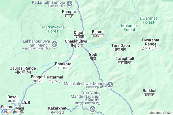
Bashkaniya Map
EDIT Map
Add Your House
 ..
..
Current Corona Virus Infected Patients Count in Almora District
| City Name | District Name | Total Covid cases |
|---|---|---|
| Almora District | Almora | 1 |
Locality Name :
Bashkaniya
( बश्कानिया )
Block Name : Chaukhutiya
District : Almora
State : Uttarakhand
Language : Hindi and Urdu
Current Time 01:42 PM
Date: Tuesday , Apr 29,2025 (IST)
Time zone: IST (UTC+5:30)
Elevation / Altitude: 345 meters. Above Seal level
Telephone Code / Std Code: 05966
Assembly constituency : Dwarahat assembly constituency
Assembly MLA : Madan Singh Bisht
Lok Sabha constituency : Almora parliamentary constituency
Parliament MP : Ajay Tamta
Serpanch Name :
Pin Code : 263656
Post Office Name : Ganai
Main Village Name : Jaicholi
Commodities Prices : Ramnagar Market / Mandi
National Highways Reachable To Bashkaniya
Nationa High Way :NH309A
Nationa High Way :NH534
Nationa High Way :NH309A
Nationa High Way :NH534
Rivers Near Bashkaniya
Kosi River
Kosi River
Kosi River
Kosi River
About Bashkaniya
Correct below Info and add more info about BashkaniyaBashkaniya is a small Village/hamlet in Chaukhutiya Block in Almora District of Uttarakhand State, India. It comes under Jaicholi Panchayath. It is located 48 KM towards North from District head quarters Almora. 2 KM from Chaukhutiya. 160 KM from State capital Dehradun
Bashkaniya Pin code is 263656 and postal head office is Ganai .
Chandikhet ( 2 KM ) , Chaukhutiya ( 2 KM ) , Dantola ( 2 KM ) , Bagari ( 3 KM ) , Fulai ( 3 KM ) are the nearby Villages to Bashkaniya. Bashkaniya is surrounded by Syaldey Block towards west , Dwarahat Block towards South , Bhikiyasain Block towards South , Gairsain Block towards North .
Almora , Nainital , Ramnagar , Pauri are the near by Cities to Bashkaniya.
This Place is in the border of the Almora District and Chamoli District. Chamoli District Gairsain is North towards this place .
Demographics of Bashkaniya
Hindi is the Local Language here.Politics in Bashkaniya
UKKD , UKDP , UKKD , BJP , INC are the major political parties in this area.Polling Stations /Booths near Bashkaniya
1)Dhankhaigaon2)Gopalgaon Tayasunra
3)Bhanotiya
4)Mahakaleshwar
5)Binta
HOW TO REACH Bashkaniya
By Rail
There is no railway station near to Bashkaniya in less than 10 km.Colleges near Bashkaniya
Govt. Inter College Masi
Address :
G I C Masi
Address :
Schools near Bashkaniya
G.h.s. Timilkhal
Address : aadi. kanojiya , chaukhutiya , almora , Uttarakhand . PIN- 263658 , Post - Masi
G.i.c. Patalgaon
Address : patalgaon , chaukhutiya , almora , Uttarakhand . PIN- 263658 , Post - Masi
G.i.c. Mahakaleshwar
Address : mehalchaura , chaukhutiya , almora , Uttarakhand . PIN- 263646 , Post - Bhatronjkhan
G.h.s. Chitreshwar
Address : bairati , chaukhutiya , almora , Uttarakhand . PIN- 263653 , Post - Dwarahat
Govt Health Centers near Bashkaniya
1) Health Sub Center Gwaldam , SC Gwaldam , , Main Market2) Health Sub Center Nandkeshri , SC Nandkeshri , , Near Nanda devi Temple
3) Health Sub Center Vijaypur , SC Vijaypur , Budjola ,
Petrol Bunks in Bashkaniya,Chaukhutiya
HP PETROL PUMP - JAI JIYA FILLING STATION
Karn Prayag Road Chaukhutia Dist- UA; Dehradun; 263656; India
3.5 KM distance Detail
HP PETROL PUMP - CHAUDHARY FUEL
NH-87E; Vill-khurudgaar Dawarahart UL; Chaukhutia Road; Uttarakhand 263653; India
14.3 KM distance Detail
more ..
Colleges in Bashkaniya,Chaukhutiya
Government Inter College
Badrinath Road; National Highway 87; Chaukhutiya; Uttarakhand 263656; India
2.4 KM distance Detail
more ..
Schools in Bashkaniya,Chaukhutiya
Saraswati Shishu / Vidya Mandir Chaukhutia
Chaukhutia Bridge; Malla Tajpur; Chaukhutiya; Uttarakhand 263656; India
2.3 KM distance Detail
Electronic Shops in Bashkaniya,Chaukhutiya
Kirola Computer & Electronics
kirola computer & electronics; Chaukhutiya; Uttarakhand; India
2.2 KM distance Detail
Amazon.in (India Largest Online Store)
bdarinath road; Chaukhutiya; Uttarakhand 263656; India
2.5 KM distance Detail
Super Markets in Bashkaniya,Chaukhutiya
Police Stations near Bashkaniya,Chaukhutiya
Police Station
Kali kholi; Tehsil Road; Sinar Rd; Dwarahat; Uttarakhand 263653; India
13.7 KM distance Detail
Governement Offices near Bashkaniya,Chaukhutiya
Tehsil Chaukhutia
Agneri Mandir Road;; Chaukhutiya; Uttarakhand 263656; India
2.9 KM distance Detail
Tahsil Office Someshwar
Tahsil Rd; Someshwar Range; Uttarakhand 263653; India
13.3 KM distance Detail
About Bashkaniya &
History
How to reach Bashkaniya
Tourist Places Near By Bashkaniya
Schools in Bashkaniya
Colleges in Bashkaniya
Temperature & weather of Bashkaniya
places in Bashkaniya
Bashkaniya photos
More Information
How to reach Bashkaniya
Tourist Places Near By Bashkaniya
Schools in Bashkaniya
Colleges in Bashkaniya
Temperature & weather of Bashkaniya
places in Bashkaniya
Bashkaniya photos
More Information
Village Talk
Post News or Events about this Village
Near Cities
Almora 46 KM near
Nainital 62 KM near
Ramnagar 64 KM near
Pauri 71 KM near
Almora 46 KM near
Nainital 62 KM near
Ramnagar 64 KM near
Pauri 71 KM near
Near By Taluks
Chaukhutiya 3 KM near
Syaldey 16 KM near
Dwarahat 17 KM near
Bhikiyasain 21 KM near
Chaukhutiya 3 KM near
Syaldey 16 KM near
Dwarahat 17 KM near
Bhikiyasain 21 KM near
Near By Air Ports
Pantnagar Airport 105 KM near
Dehra Dun Airport 153 KM near
Muzaffarnagar Airport 191 KM near
Simla Airport 283 KM near
Pantnagar Airport 105 KM near
Dehra Dun Airport 153 KM near
Muzaffarnagar Airport 191 KM near
Simla Airport 283 KM near
Near By Tourist Places
Dwarahat 13 KM near
Gairsain 26 KM near
Kasauni 26 KM near
Ranikhet 29 KM near
Jageshwar 36 KM near
Dwarahat 13 KM near
Gairsain 26 KM near
Kasauni 26 KM near
Ranikhet 29 KM near
Jageshwar 36 KM near
Near By Districts
Bageshwar 44 KM near
Almora 46 KM near
Nainital 62 KM near
Rudra Prayag 65 KM near
Bageshwar 44 KM near
Almora 46 KM near
Nainital 62 KM near
Rudra Prayag 65 KM near
Near By RailWay Station
Ramnagar Rail Way Station 65 KM near
Kathgodam Rail Way Station 77 KM near
Ramnagar Rail Way Station 65 KM near
Kathgodam Rail Way Station 77 KM near