| Home | City Bus | Maps | Villages | Cities | Rail | Tourist Places | School | College | Pin Codes | Corona Cases Count |
| Distance Calculator Bus Services IFSC Codes Trace Mobile Number Weather Search Place Trace IP Available Cash ATM/Banks Locate Polling Booth Report an Error contact People |
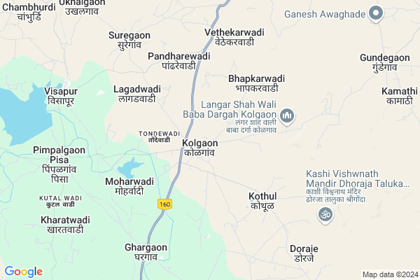
Kolgaon
Kolgaon Map
EDIT Map
Add Your House
 ..
..
Current Corona Virus Infected Patients Count in Ahmednagar District
| City Name | District Name | Total Covid cases |
|---|
Locality Name :
Kolgaon
( कोळगाव )
Taluka Name : Shrigonda
District : Ahmednagar
State : Maharashtra
Region : Khandesh and Northern Maharashtra
Division : Nashik
Language : English and Hindi, Marathi, Urdu
Current Time 09:14 AM
Date: Wednesday , Apr 30,2025 (IST)
Time zone: IST (UTC+5:30)
Telephone Code / Std Code: 02487
Assembly constituency : Shrigonda assembly constituency
Assembly MLA : Pachpute Babanrao Bhikaji
Lok Sabha constituency : Ahmednagar parliamentary constituency
Parliament MP : Dr. SUJAY RADHAKRISHNA VIKHEPATIL
Serpanch Name :
Pin Code : 413728
Post Office Name : Kolgaon
Commodities Prices : Shrigonda(Gogargaon) Market / Mandi
Kolgaon Live Weather
Temperature: 26.8 °C
clear sky
Humidity: 43%
Wind : 2.7 mt/sec towards NW
StationName : "Shrīgonda"
observed on 2 Hours Back
Temperature: 26.8 °C
clear sky
Humidity: 43%
Wind : 2.7 mt/sec towards NW
StationName : "Shrīgonda"
observed on 2 Hours Back
Kolgaon Weather Forecast for Next 5 days
01-05-2025
28.7°C to 39.4°C
clear sky, few clouds
28.7°C to 39.4°C
clear sky, few clouds
02-05-2025
27.3°C to 40.0°C
clear sky, broken clouds
27.3°C to 40.0°C
clear sky, broken clouds
03-05-2025
27.5°C to 39.6°C
clear sky, few clouds, broken clouds, scattered clouds
27.5°C to 39.6°C
clear sky, few clouds, broken clouds, scattered clouds
04-05-2025
26.3°C to 38.7°C
clear sky, few clouds, scattered clouds, broken clouds
26.3°C to 38.7°C
clear sky, few clouds, scattered clouds, broken clouds
05-05-2025
24.5°C to 36.2°C
clear sky, few clouds, light rain, scattered clouds, broken clouds
24.5°C to 36.2°C
clear sky, few clouds, light rain, scattered clouds, broken clouds
Edit below overview about Kolgaon
Edit below overview about Kolgaon
OverView of Kolgaon
KOLGAON It is situated in Shrigonda taluka at a distance of twelve miles to the north-west of Shrigonda, the head-quarters of a taluka. The village covers an area of 28.9 square miles and has a population of 6,648 souls as per the Census of 1971. The village has a post office. Village Kolgaon famous because of The Great Saint (PIR) Hazarat Rahemuttula *Sayyed Ahmedshah* known as "kolgaon ke Baba." His Devine miracles blessings are speechless and all persons irrespective caste, religion, boundary having great faith, belief and respect for Him. He was aboved 125 years old while left the word and every year after Bakri Eid forthcoming first week His "Sandal Urs" celebrated for which people came across india and NRI also. During year 1973 to 1975 Kolgaon wale Baba gifted His Devine powers to One of Child to save his life. Said boy is son of His Murid, namely Late. Sayyed Rajasahab Nalwale resided at Panchpir Chawadi, Ahmednagar. Late. Mrs. Sayyed Sharifabee Sayyed Rajasahab is religious family devoted by showers of blessings by Almighty Allah through Kolgaon wale Baba.Wells form the main source of water-supply. Educational facilities arc provided in the village by one high school known as Shri Kolaidevi Vidyalaya besides the primary schools conducted by the Zilla Parishad. Medical facilities are provided by the private medical practitioners and the primary health centre conducted by the Zilla Parishad. The weekly market is held in the village on every Wednesday. A Government rest-house is also located in the village. A library is conducted in the village by the Shrigonda Panchayat Samiti. The village contains a memorial to the soldiers who lost their lives in the First World War. The village is said to have come to be known as Kolgaon after the goddess Kolaidevi in whose honour, every year, a fair is held on Chaitra Shuddha Paurnima (March-April) which is attended by about one thousand persons. Another fair is held in the village in honour of Lakshmi Ai on Ashadha Paurnima (June-July). About 1,500 persons assemble at the time of this fair. The only object of interest in the village is a Hemadpanti temple dedicated to Valkeshvar. The temple has nine domes and a sunk shrine with a linga. The pillars are well carved with figures on their capitals but they are entirely covered with plaster. On each side of the hall is a recess not under use. In front of the door are the remains of a veranda built of large blocks of stone let into each other in receding courses. To the left of the veranda is a new shrine with a linga and in front is a Nandi under a four-pillared dome. Over the temple shrine is the usual brick and plaster dome. In front of the temple is a brick lamp-pillar with a staircase inside. The original outside of the temple has been removed and replaced by modern masonry. [ Ahmadnagar District Gazetteer. 1884.] The ceiling of the inner shrine of the temple has recently been renovated. A small fair is celebrated at the temple on the full-moon day of the month of Chaitra.Kolgaon is a historical place. First Church in Ahmednagar district built in Kolgaon in 1853.
Edit below overview about Kolgaon
National Highways Reachable To Kolgaon
Nationa High Way :NH548D
Nationa High Way :NH160
Nationa High Way :NH548D
Nationa High Way :NH160
Rivers Near Kolgaon
Vel :वेळ
Velu :वेळ
Vel :वेळ
Velu :वेळ
About Kolgaon
Kolgaon is a Village in Shrigonda Taluka in Ahmednagar District of Maharashtra State, India. It belongs to Khandesh and Northern Maharashtra region . It belongs to Nashik Division . It is located 42 KM towards South from District head quarters Ahmednagar. 13 KM from Shrigonda. 224 KM from State capital Mumbai
Kolgaon Pin code is 413728 and postal head office is Kolgaon .
Kothul ( 4 KM ) , Ghargaon ( 7 KM ) , Mungusgaon ( 7 KM ) , Ghotavi ( 7 KM ) , Suregaon ( 8 KM ) are the nearby Villages to Kolgaon. Kolgaon is surrounded by Nagar Taluka towards North , Ahmednagar Taluka towards North , Karjat Taluka towards East , Parner Taluka towards North .
Shrigonda , Shirur , Ahmednagar , Daund are the near by Cities to Kolgaon.
Kolgaon 2011 Census Details
Kolgaon Local Language is English. Kolgaon Village Total population is 9276 and number of houses are 2026. Female Population is 48.1%. Village literacy rate is 70.2% and the Female Literacy rate is 30.2%.
Population
| Census Parameter | Census Data |
| Total Population | 9276 |
| Total No of Houses | 2026 |
| Female Population % | 48.1 % ( 4460) |
| Total Literacy rate % | 70.2 % ( 6511) |
| Female Literacy rate | 30.2 % ( 2798) |
| Scheduled Tribes Population % | 3.0 % ( 274) |
| Scheduled Caste Population % | 11.7 % ( 1081) |
| Working Population % | 53.9 % |
| Child(0 -6) Population by 2011 | 1081 |
| Girl Child(0 -6) Population % by 2011 | 44.6 % ( 482) |
Kolgaon Census More Deatils.
Politics in Kolgaon
Bharatiya Janata Party , BJP , NCP are the major political parties in this area.Polling Stations /Booths near Kolgaon
1)Kolgaon Z P School North South Building Room No 1 From North Side2)Kolgaon Kolaidevi Vidyalay New Building Room No 3 From East Side
3)Kolgaon Z P School East West Building Room No 1 From East Side
4)Kolgaon Z P School East West Building Room No 5 From East Side
5)Kokangaon Z.p. School South-north Building Room No 2 From South Side
HOW TO REACH Kolgaon
By Road
Ahmednagar is the Nearest Town to Kolgaon. Ahmednagar is 33 km from Kolgaon. Road connectivity is there from Ahmednagar to Kolgaon.By Rail
Visapur Rail Way Station is the very nearby railway stations to Kolgaon. Also you can consider railway Stations from Near By town Ahmednagar. Ahmednagar Rail Way Station are the railway Stations near to Ahmednagar. You can reach from Ahmednagar to Kolgaon by road after .Colleges near Kolgaon
Indira Gandhi Polytechnic
Address :
Janata Vidyalaya,kashti,a.nagar
Address :
Hon Shri Babanrao Pachpute Vichardhara Trust,parikrama,group Of Institutions
Address :
Schools in Kolgaon
Kolaidevi V.kolgaon
Address : kolgaon , shrigonda , ahmadnagar , Maharashtra . PIN- 413728 , Post - Kolgaon
Govt Health Centers near Kolgaon
1) Kolgaon , , Dhorja Road , Near S T stand2) Dhorja , , Dhorja Road , Near Grampanchayat
3) Ghargaon , Ghargaon , 0 , near Police station
Sub Villages in Kolgaon
Hospitals in Kolgaon,Shrigonda
Dr. Rajesh Kandekar Hospital
Kolgaon Bus Stand; Kolgaon; Maharashtra 413728; India
0.9 KM distance Detail
more ..
Petrol Bunks in Kolgaon,Shrigonda
Indian Oil Petrol Pump
Ghargaon; Ahmadnagar; SH-10; Ahmed Nagar Yeola Road; Ahmednagar; Ahmednagar; Maharashtra 413728; India
6.5 KM distance Detail
more ..
Colleges in Kolgaon,Shrigonda
Saikrupa Polytechnic
Survey No.244; Ghargaon; Shrigonda; Ahmednagar; Maharashtra 413728; India
0.8 KM distance Detail
Sai Krupa Institute of Management Science
451; Ghargaon; Tal. Shrigonda; Ahmednagar; Maharashtra 413728; India
0.8 KM distance Detail
Saikrupa College Of Agriculture And Food Technology
Ghargaon; Maharashtra 413728; India
8.3 KM distance Detail
more ..
Schools in Kolgaon,Shrigonda
DHEY CAREER ACADEMY
KOLGAON (NAHER MALA); TAL- SHRIGONDA; DIST- AHMEDNAGAR; Kolgaon; Maharashtra 413728; India
0.8 KM distance Detail
Municipal Primary School
Ward No 11 Kolgaon; Juna Bhen; Ambarnath; Maharashtra 421501; India
0.8 KM distance Detail
Saikrupa English Medium School Kolgaon
Main Rd; Kolgaon; Maharashtra 413728; India
0.8 KM distance Detail
Electronic Shops in Kolgaon,Shrigonda
bunty's MOBILE PLANET(multibrand mobile shop)
Kolgaon; Maharashtra 413728; India
1.0 KM distance Detail
Super Markets in Kolgaon,Shrigonda
धिरज किराणा अँड जनरल स्टोअर्स
दत्त मंदिर चौक; सूरेगाव; Maharashtra 413703; India
7.8 KM distance Detail
Local Parks in Kolgaon,Shrigonda
Police Stations near Kolgaon,Shrigonda
Governement Offices near Kolgaon,Shrigonda
Gram Panchayat Office Gundegaon
काशी विश्वनाथ मंदिर रोड; दोरजे; महाराष्ट्र 413728; India
11.7 KM distance Detail
Sidhheshwar Mangal Karyalay And Garrden Lawn
Belwandi Bk.; Maharashtra 413702; India
13.2 KM distance Detail
About Kolgaon &
History
How to reach Kolgaon
Tourist Places Near By Kolgaon
Schools in Kolgaon
Colleges in Kolgaon
Temperature & weather of Kolgaon
places in Kolgaon
Kolgaon photos
More Information
How to reach Kolgaon
Tourist Places Near By Kolgaon
Schools in Kolgaon
Colleges in Kolgaon
Temperature & weather of Kolgaon
places in Kolgaon
Kolgaon photos
More Information
Village Talk
Post News or Events about this Village
Near Cities
Shrigonda 23 KM near
Shirur 34 KM near
Ahmednagar 38 KM near
Daund 42 KM near
Shrigonda 23 KM near
Shirur 34 KM near
Ahmednagar 38 KM near
Daund 42 KM near
Near By Taluks
Shrigonda 13 KM near
Nagar 38 KM near
Ahmednagar 39 KM near
Karjat 43 KM near
Shrigonda 13 KM near
Nagar 38 KM near
Ahmednagar 39 KM near
Karjat 43 KM near
Near By Air Ports
Lohegaon Airport 92 KM near
Chikkalthana Airport 157 KM near
Gandhinagar Airport 176 KM near
Sholapur Airport 208 KM near
Lohegaon Airport 92 KM near
Chikkalthana Airport 157 KM near
Gandhinagar Airport 176 KM near
Sholapur Airport 208 KM near
Near By Tourist Places
Ahmednagar 35 KM near
Vadhu Tulapur 76 KM near
Ozar 96 KM near
Pune 102 KM near
Pimpri-Chinchwad 104 KM near
Ahmednagar 35 KM near
Vadhu Tulapur 76 KM near
Ozar 96 KM near
Pune 102 KM near
Pimpri-Chinchwad 104 KM near
Near By Districts
Ahmednagar 39 KM near
Pune 101 KM near
Beed 130 KM near
Aurangabad District 156 KM near
Ahmednagar 39 KM near
Pune 101 KM near
Beed 130 KM near
Aurangabad District 156 KM near
Near By RailWay Station
Visapur Rail Way Station 9.3 KM near
Ahmednagar Rail Way Station 34 KM near
Daund Junction Rail Way Station 43 KM near
Visapur Rail Way Station 9.3 KM near
Ahmednagar Rail Way Station 34 KM near
Daund Junction Rail Way Station 43 KM near