| Home | City Bus | Maps | Villages | Cities | Rail | Tourist Places | School | College | Pin Codes | Corona Cases Count |
| Distance Calculator Bus Services IFSC Codes Trace Mobile Number Weather Search Place Trace IP Available Cash ATM/Banks Locate Polling Booth Report an Error contact People |
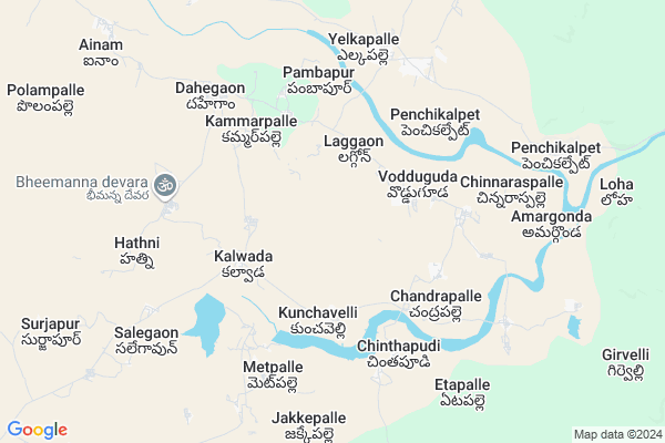
Kothagudem Map
EDIT Map
Add Your House
 ..
..
Current Corona Virus Infected Patients Count in Adilabad District
| City Name | District Name | Total Covid cases |
|---|---|---|
| Adilabad District | Adilabad | 18 |
| Nirmal District | Nirmal | 17 |
Locality Name :
Kothagudem
( కొత్తగూడెం )
Mandal Name : Dahegaon
District : Adilabad
State : Telangana
Region : Telangana
Language : Telugu and Urdu
Current Time 08:45 AM
Date: Wednesday , Apr 30,2025 (IST)
Time zone: IST (UTC+5:30)
Elevation / Altitude: 181 meters. Above Seal level
Telephone Code / Std Code: 08738
Assembly constituency : Sirpur assembly constituency
Assembly MLA : Dr.Palvai Harish Babu
Lok Sabha constituency : Adilabad parliamentary constituency
Parliament MP : SOYAM BAPU RAO
Serpanch Name :
Pin Code : 504273
Post Office Name : Rechini
Main Village Name : Keslapur
Commodities Prices : Kagaznagar Market / Mandi
Kothagudem Live Weather
Temperature: 29.3 °C
scattered clouds
Humidity: 54%
Wind : 5.03 mt/sec towards S
StationName : "Bellampalli"
observed on 2 Hours Back
Temperature: 29.3 °C
scattered clouds
Humidity: 54%
Wind : 5.03 mt/sec towards S
StationName : "Bellampalli"
observed on 2 Hours Back
Kothagudem Weather Forecast for Next 5 days
01-05-2025
29.7°C to 43.0°C
scattered clouds, few clouds, clear sky
29.7°C to 43.0°C
scattered clouds, few clouds, clear sky
02-05-2025
28.3°C to 43.5°C
scattered clouds, clear sky, few clouds
28.3°C to 43.5°C
scattered clouds, clear sky, few clouds
03-05-2025
28.7°C to 43.4°C
clear sky, scattered clouds
28.7°C to 43.4°C
clear sky, scattered clouds
04-05-2025
27.6°C to 43.8°C
few clouds, clear sky, light rain
27.6°C to 43.8°C
few clouds, clear sky, light rain
05-05-2025
29.7°C to 40.7°C
moderate rain, broken clouds, scattered clouds, few clouds, overcast clouds, light rain
29.7°C to 40.7°C
moderate rain, broken clouds, scattered clouds, few clouds, overcast clouds, light rain
National Highways Reachable To Kothagudem
Nationa High Way :NH353C
Nationa High Way :NH353C
Rivers Near Kothagudem
Raja Vagu
Dongri
Raja Vagu
Dongri
About Kothagudem
Correct below Info and add more info about KothagudemKothagudem is a small Village/hamlet in Dahegaon Mandal in Adilabad District of Telangana State, India. It comes under Keslapur Panchayath. It belongs to Telangana region . It is located 159 KM towards East from District head quarters Adilabad.
Kothagudem Pin code is 504273 and postal head office is Rechini .
Kothagudem is surrounded by Bheemini Mandal towards west , Vemanpally Mandal towards South , Bejjur Mandal towards North , Nennel Mandal towards South .
Kagaznagar , Bellampalle , Mandamarri , Mancherial are the near by Cities to Kothagudem.
Demographics of Kothagudem
Telugu is the Local Language here. Total population of Kothagudem is 805 .Males are 403 and Females are 402 living in 180 Houses. Total area of Kothagudem is 1270 hectares.Politics in Kothagudem
TDP , TRS , BSP , INC are the major political parties in this area.Polling Stations /Booths near Kothagudem
1)Balaji Ankoda2)Kaghaz Nagar Tirandaz Talkies Booking Office
3)Borlakunta
4)Kunchavelli
5)Kukuda
HOW TO REACH Kothagudem
By Road
Kagaznagar is the Nearest Town to Kothagudem. Kagaznagar is 23 km from Kothagudem. Road connectivity is there from Kagaznagar to Kothagudem.By Rail
There is no railway station near to Kothagudem in less than 10 km. How ever there are railway Stations from Near By town Kagaznagar. are the railway Stations near to Kagaznagar. You can reach from Kagaznagar to Kothagudem by road after .Colleges near Kothagudem
Govt. Polytechnic Bellampalli
Address :
Viveka Vardhini Degree&pg Clg
Address :
Rebbena Arts & Science Degree College
Address :
Govt Junior College
Address :
Kakathiya Junior Collage
Address :
Schools in Kothagudem
Mpps Kothagudem
Address : keslapur , dahegoan , adilabad , Andhra Pradesh . PIN- 504273 , Post - Rechini
Mpps Gattupally
Address : keslapur , dahegoan , adilabad , Andhra Pradesh . PIN- 504273 , Post - Rechini
Mpps Keslapur
Address : keslapur , dahegoan , adilabad , Andhra Pradesh . PIN- 504273 , Post - Rechini
Govt Health Centers near Kothagudem
1) SubCentre, Satwajiguda , , ,2) SubCentre, Pambapur , 10-Apr , S.C.Wada , S.C.Wada
3) Primary Health Centre, Penchikalpet , , Mani , Near bus Stop
Electronic Shops in Kothagudem,Dahegaon
Super Markets in Kothagudem,Dahegaon
Local Parks in Kothagudem,Dahegaon
Police Stations near Kothagudem,Dahegaon
Governement Offices near Kothagudem,Dahegaon
About Kothagudem &
History
How to reach Kothagudem
Tourist Places Near By Kothagudem
Schools in Kothagudem
Colleges in Kothagudem
Temperature & weather of Kothagudem
places in Kothagudem
Kothagudem photos
More Information
How to reach Kothagudem
Tourist Places Near By Kothagudem
Schools in Kothagudem
Colleges in Kothagudem
Temperature & weather of Kothagudem
places in Kothagudem
Kothagudem photos
More Information
Village Talk
Post News or Events about this Village
Near Cities
Kagaznagar 35 KM near
Bellampalle 36 KM near
Mandamarri 41 KM near
Mancherial 55 KM near
Kagaznagar 35 KM near
Bellampalle 36 KM near
Mandamarri 41 KM near
Mancherial 55 KM near
Near By Taluks
Dahegaon 0 KM near
Vemanpally 17 KM near
Bheemini 17 KM near
Bejjur 18 KM near
Dahegaon 0 KM near
Vemanpally 17 KM near
Bheemini 17 KM near
Bejjur 18 KM near
Near By Air Ports
Sonegaon Airport 246 KM near
Nanded Airport 286 KM near
Rajiv Gandhi International Airport 291 KM near
Raipur Airport 337 KM near
Sonegaon Airport 246 KM near
Nanded Airport 286 KM near
Rajiv Gandhi International Airport 291 KM near
Raipur Airport 337 KM near
Near By Tourist Places
Sirpur 37 KM near
Bhamragarh Wildlife Sanctuary 101 KM near
Chandrapur 105 KM near
Medaram 126 KM near
Tadoba 133 KM near
Sirpur 37 KM near
Bhamragarh Wildlife Sanctuary 101 KM near
Chandrapur 105 KM near
Medaram 126 KM near
Tadoba 133 KM near
Near By Districts
Chandrapur 104 KM near
Karimnagar 122 KM near
Gadchiroli 123 KM near
Bijapur 135 KM near
Chandrapur 104 KM near
Karimnagar 122 KM near
Gadchiroli 123 KM near
Bijapur 135 KM near
Near By RailWay Station
Sirpur Kaghaznagar Rail Way Station 34 KM near
Bellampalli Rail Way Station 37 KM near
Sirpur Kaghaznagar Rail Way Station 34 KM near
Bellampalli Rail Way Station 37 KM near